We are certain that Western Washington will be plunged into the freezer this week. However, with that cold comes the potential for lowland snow. The snow potential is uncertain right now.
This graphic from NWS Seattle illustrates what we know, don't know, and what you should do.

Let's take a look at the temperature forecast. Below is the forecast for Puyallup from The Weather Channel.

Temperatures get progressively colder all week, bottoming out on Friday. It is important to note that temperatures can, and possibly will, get colder than this forecast indicates.
Do not rule out low temperatures of 17-23 degrees from Thursday to Saturday.
Additionally, brisk N-NE winds will bring very cold wind chills of 10-20 degrees from Thursday through Saturday. Even colder wind chills, down to the single digits, are possible in wind gusts.
Expect N-NE winds of 10-15 mph, with gusts of 15-30 mph. The 20+ mph gusts combined with temperatures not exceeding freezing are what form these dangerous wind chills. Below is an informative graphic from the NWS about the science of wind chill.

As of Monday night, there are 2 possible times for snow events.
Chance #1: Wednesday night/Thursday morning (smaller-impact event)
On Wednesday night, a modified arctic front will move through the Puget Sound area, bringing colder temperatures and a chance of snow. This snow chance is not very likely, but should it occur, expect an area of heavier snow (2-5") between SeaTac and Seattle (and eastward), with lesser amounts (0.5-1.5 inches) in the South Sound.
Chance #2: Thursday into Saturday (potentially larger-impact event)
In weather forecasting, forecasts are generally determined by forecast models, which are systems that predict upcoming weather. 2 major forecast models are the European Model (aka “Euro” or ECMWF) and the American Model (GFS).
Below is the Euro model ensemble forecast (many forecasts put together) for SeaTac airport. Most of the ensemble members show significant snow (5-18 inches) at SeaTac airport.
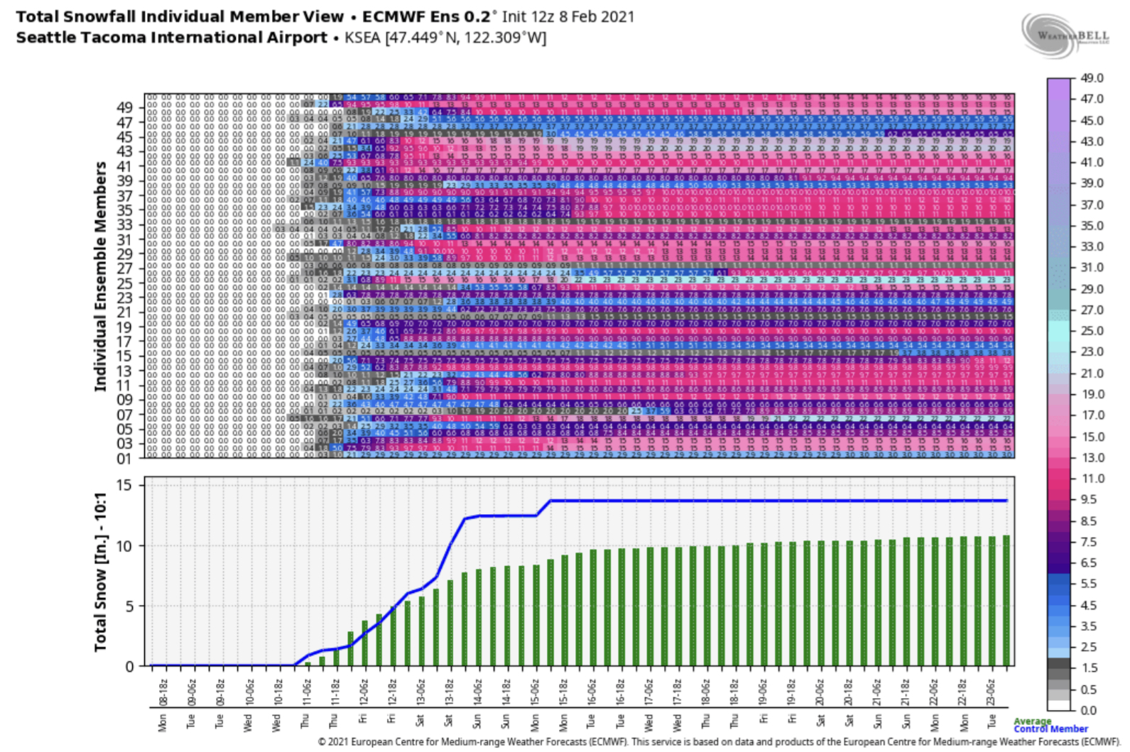 |
| Image courtesy Cliff Mass Weather Blog and WeatherBell. |
However, a forecast isn’t good unless you compare multiple predictions.
Below is another forecast ensemble, but instead from the GFS (American) Model.

Far less ensemble members show heavy snow, with an average at SeaTac airport of 5-7 inches. I’d expect about the same for the South Sound in this scenario.
Bottom line: The Euro says 10-14 inches, the GFS says 5-7 inches, and the GFS has been trending lesser on snow amounts across the Puget Sound area.
This all means that there’s A LOT of uncertainty. (Would it be a Seattle snowstorm without uncertainty??)
Expect that through the next couple days we will see forecasts start to align a bit more on a solution...but until then, stay tuned. Lots will change.
I will be posting nightly updates on the blog as this winter weather situation continues. Be sure to check back each night!

No comments:
Post a Comment