Saturday was breezy with scattered showers and some elusive sunbreaks early on.
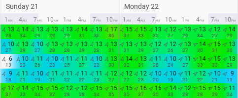
Starting on Sunday, it will get breezy across Western Washington, as seen in the forecast below for Puyallup.
Expect winds gusting 25-40 mph from Sunday morning to Monday night, peaking Sunday night and Monday morning.
Sunday night and Monday morning will also be the time when the heaviest rain moves through Western Washington. The map below shows total rain through 4 AM Tuesday.
Notice the rain shadow (area of less rain accumulation) over North Seattle. This is because of westerly flow. As you can see, there is much more rain on the west slopes of the Olympics, but far less immediately east. That is due to the Olympics blocking the incoming rain and soaking it up on the west slopes. A similar phenomenon is seen in the Cascade foothills.
Expect 0.4-1.2 inches of rain for the Tacoma/Puyallup areas, where the rain shadow effect will not be as prominent.
This system will also bring a lot of mountain snow. Below is accumulated snowfall through 4 AM Tuesday.
Expect some big totals. The UW model above forecasts 1-2 feet at Snoqualmie Pass and a whopping 2-4 feet at Stevens Pass. This heavy snow will create winter driving conditions on the passes. Take caution if you are traveling in the mountains (and skiers...enjoy that snow!!). Avalanche danger is also high. The Northwest Avalanche Center has issued an Avalanche Warning for Sunday (below).
Here is a day-by-day precipitation forecast for Puyallup from Weather Underground. This helps to know exactly when the most rain is expected.
Expect the most rain on Sunday (mainly later in the day) and on Monday.


No comments:
Post a Comment