Tuesday, December 29, 2020

Rain & Breezy Weather Returns

An area of steady rain is moving into Western Washington as of Tuesday night. This is part of a return to a stormy pattern to round out 2020 and begin 2021. 

Expect rain and breezy weather to continue through early Thursday.

The rain forecast through 4 PM Thursday (New Year's Eve) from the UW WRF Model is below.


Expect 0.5-1.3 inches of rain through New Year's Eve. That's not all...a whole lot more rain is coming for the beginning of January. It looks like 2021 will kick off with some active weather.

Wednesday and Thursday will also be breezy to windy across the Puget Sound area, strongest on the coast and north of Everett. The 4-model blend of wind forecasts for Puyallup is below.


Winds will increase early Wednesday morning and stay breezy through midday Thursday. Peak gusts will likely be 25-40 mph. 

This seems like a fitting way to end 2020, which has been an exceptionally windy year. For those of you who like stats, we have had nearly 45 days with 25+ mph winds in 2020! That's 20-30 more days than in 2019. Crazy!!!

I'm sure you're wondering about the forecast for the night of New Year's Eve into New Year's Day. It looks like we'll have a break (of sorts) from rain and wind for the 11 PM-1 AM hours.

Rain will lessen and likely be more of the showery variety and winds will lessen to 10-20 mph during 11 PM-1 AM. 

As we begin 2021, more rainy, windy, and mountain-snow producing systems are in the cards.

Sunday, December 27, 2020

Sunny & Chilly, Rain Returns By Wednesday

After a mostly cloudy past few days, clouds are moving out on Sunday night, making way for low temperatures of 27-34 degrees and patchy freezing fog on Monday and Tuesday mornings.

Freezing fog brings a high threat of black ice, especially on bridges and overpasses, but also on non-elevated roadways. Be safe when driving in freezing fog!

By Tuesday night, we will transition to a much wetter pattern. Take a look at the Puyallup rain forecast from Weather Underground.


It will be quite rainy, with 2-5 inches of rain possible through next Tuesday (5th). Expect plentiful mountain snow as well.

Wind is also possible during this stretch, with gusts of 30-40 mph possible on Wednesday. 

More windy days, with lots of rain as well, are likely as we transition into a stormier pattern to end 2020 and start 2021.

Thursday, December 24, 2020

Christmas Forecast: Chilly Morning, Rain Likely

Christmas morning will be a chilly one, with lows of 30-38 degrees around the area. 

Rain associated with an incoming frontal system will reach Puget Sound midday, continuing at times through Saturday night. Below is the UW forecast model showing precipitation through 4 PM Saturday.


Expect up to 0.6 inches of rain through the next couple days.

Highs will reach the mid-40s on Christmas.

Have a Merry Christmas!

Tuesday, December 22, 2020

Sunny & Chilly Through Thursday, Rain By Christmas

After a crazy weather day on Monday, with rain, wind, balmy temperatures, and snow, we have calm weather! 

Nights will be cold across the area, with lows of 26-35 degrees. Daytime highs will get to the mid 40s.

Take a look at the Euro model’s forecast lows on Tuesday night/Wednesday morning.


Expect chilly lows of 26-30 degrees by Wednesday morning. Any leftover moisture will likely refreeze by Wednesday morning. Be prepared for spotty black ice and icy spots.

Highs on Wednesday will top out in the low to mid 40s.

Another chilly night with lows of 27-34 degrees is likely on Christmas Eve morning, and a sunny Christmas Eve, with increasing clouds late, and highs in the mid 40s.

Rain returns for a couple days starting on Christmas. Despite the return of rain, active weather isn’t likely...just our typical pattern.

Below is the Puyallup 10-day forecast from weather.com.


This shows a relatively normal pattern in store for Western Washington, with average temperatures and seasonal conditions.

Monday, December 21, 2020

Update: Temperature Swings, Local Flooding, Snow Still Possible

Update 8:35 PM:

Snow or a rain/snow mix is falling across much of the South/Central Sound. Snow will taper through the next hour, with a cold night (32-36 degrees) ahead. Be safe and enjoy the beauty of snowflakes falling!

Update 7:35 PM:

It is snowing across Puget Sound!! Some snow is accumulating on grassy, non-road surfaces, with some isolated spots with snowy roads. Expect snow to continue until 8:30-9:30 PM. Enjoy the snow!!


I took the photo above on my deck around 7:00 PM!

Update 6:40 PM:

It is snowing in Federal Way and Bonney Lake, along with many locations to the north. Conditions are conducive for snow for another couple hours, until roughly 9 PM. Don't expect accumulations on roads for the time being.

Comment below with pictures/videos/reports!!

5:00 PM Update Below. Hourly updates will be above this.

As of 5 PM, temperatures are beginning to cool around the South Sound. Temperatures spiked to 55-63 degrees ahead of the warm front midday, accompanied by winds gusting 30-45 mph. The 5 PM NWS temperature observations show roughly where the cold air is located.


Temperatures are cooling fast, with a drop from 50 to 43 in about 30 minutes!

In addition to cooling temperatures, heavy rain has moved through the Puget Sound area in the past couple hours, with urban flooding occurring in parts of the region.

The 4 PM radar image showed a heavy band of rain with more heavy rain behind it.


This brought strong winds, very heavy rain, and localized flooding. Most of the South/Central Sound received 0.2-0.5 inches of rain in 3 hours.

Now for snow...cold air is moving in behind the cold front. With the presence of moisture, there is a chance of snow until roughly 9 PM. 

A rain/snow mix is the most likely scenario, with all snow possible with heavier precipitation and temperatures below 33-35 degrees. Most places recording mix or snow have temperatures below 37 degrees, so there’s a “benchmark” of sorts.

Radar at 5:30 PM shows a rain/snow line just north of Seattle. This has been moving south with the colder temperatures.


A rain/snow mix is possible in the few miles south of the rain/snow line. The best shot at snow is through 9 PM. After that, moisture will be moving out of the area.

I’ll try to put hourly updates at the top of this blog post. Stay tuned!!

Sunday, December 20, 2020

Active Weather Day on Monday

Monday will likely be an active and interesting weather day around Western Washington, with rain, wind, a big temperature drop, and potential snow all in the cards. Let's take a look!

Starting late Sunday night, rain will move into Western WA. This rain will continue through Monday evening. Below is NWS Seattle's forecast for total rain with this storm.


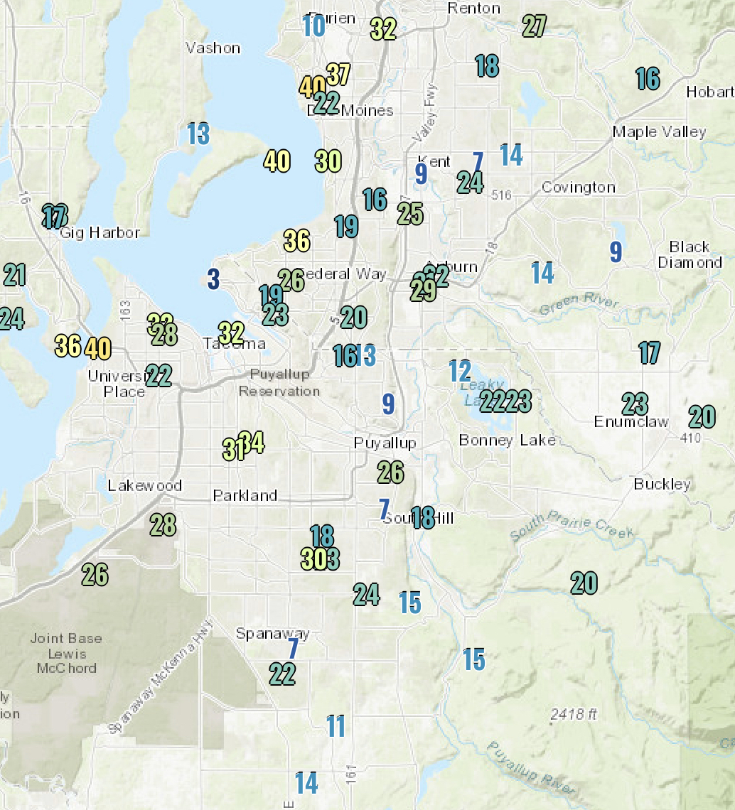
Expect 1-1.5 inches of rain. That's enough to cause localized urban flooding, ponding, and standing water. Rain will likely be moderate to heavy at times, especially on Monday.

Next is the wind. Since all of this mayhem is caused by a low pressure system, wind is in the cards. The cold front associated with this system will bring winds gusting 30-50 mph during the day on Monday.


The blend of 4 forecast models for Puyallup shows strong gusts of 30-50 mph prior to the cold front. Expect similar winds around the area. Be prepared for localized tree damage and isolated power outages.

Another aspect of this weather system will be the temperatures. Sunday was warmer than usual, with temperatures of 47-55 degrees most of the day. Temperatures will remain in the mid-40s overnight into Monday, before peaking at 52-57 degrees during the day on Monday. Then, a big swing takes place. Temperatures will drop from 52-57 to 33-43 degrees as the cold front moves through on Monday afternoon. This swing will take place within hours, and it will set the stage for what you've been wanting to know about...

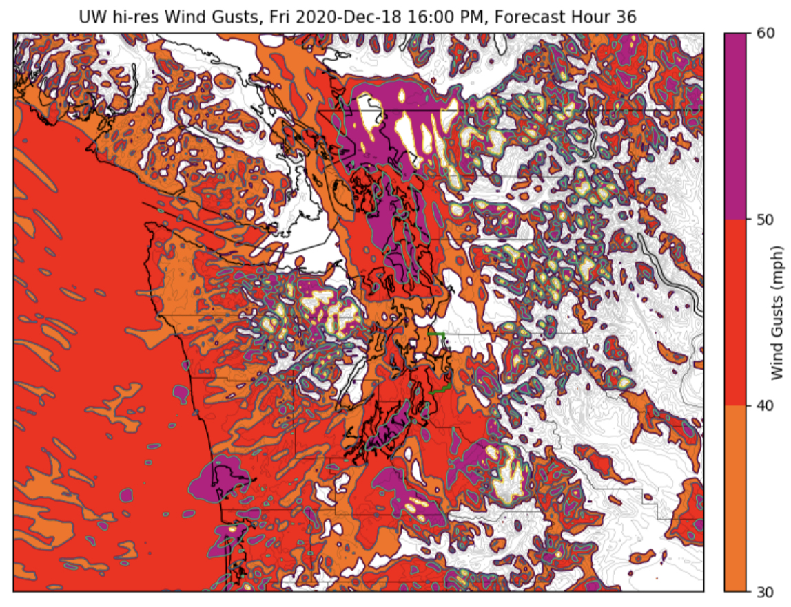
There is a chance of lowland snow on Monday afternoon and into the evening. The graphic below from NWS Seattle communicates the uncertainty ahead.


I expect that snowflakes will fall, either as heavy rain/snow mix or as snow. Snow accumulations are unlikely, except for some grassy surfaces away from the water and above sea level. It is unlikely that roads will be impacted, due to ground temperatures being above freezing.

The reason that this is a very challenging snow forecast is that there is a lack of cold air, the track of the incoming low matters (it can come down to miles), and there is a chance of a Convergence Zone (when air flows around the Olympic Mtns. and converges over parts of the Puget Sound area) snow band dropping more snow in select areas. Additionally, the temperature matters. Too warm during the day, much less of a snow chance. If the temperature drops into the low-mid 30s, there's a "better" snow chance. 

Let's talk snow accumulation. Don't expect much. A trace or a bit more is possible on grassy surfaces, with the highest likelihood of this in the Cascade foothills or higher hills around the area. Snow, if any, will end by late Monday evening.

There's not enough accumulation expected (or enough confidence in that forecast) to bring out the snow maps, but don't be surprised to see snowflakes!

Congratulations! You made it to the end of this blog. There's enough going on to warrant a summary at the end:

  • Rain, heavy at times, will last from Sunday night to Monday evening, totaling 1-1.5 inches
  • This rain could cause ponding and standing water, along with possible urban flooding
  • Due to the incoming cold front, winds gusting 30-50 mph are possible on Monday as well
  • Temperatures on Monday will peak in the mid-50s, dropping to 33-45 degrees by Monday evening (a drop happening in a matter of hours)
  • Due to incoming cold air, there is a chance of mostly non-accumulating lowland snow Monday afternoon and evening
  • A heavy rain/snow mix or brief heavy snow is possible
Stay tuned! There is still a lot of uncertainty in the forecast.

Saturday, December 19, 2020

Rain, Breezy Winds, and a Possible Chance of Snow

We are in for an interesting few days of weather in Western Washington! Let's dive into the details!

The focus shifts to rain over the weekend and on Monday. This forecast from NWS Seattle shows forecast precipitation through 4 PM Monday. 


Expect 1.5-2 inches of rain across the South Sound. Some of the impacts of the rain are shown below. (Also from NWS Seattle).


Daytime on Sunday will be more of a break between rainy systems, but expect rain early and late on Sunday. Like the graphic says, most rain will fall Saturday night. Expect another rainy day on Monday. Rises on area rivers are likely, but not to the extent of flood stage.

Winds are possible during this time frame as well, with gusts of 30-45 mph possible Saturday night and during the day on Monday.

As if this is not enough weather activity...things get even more interesting Monday afternoon, as there is an uncertain chance of lowland snow on Monday afternoon/evening. Yes, a chance of snow. You read that right.

This graphic from NWS Seattle shows what the situation is like as of Saturday.


It is too early to talk about snow accumulations. There is substantial uncertainty regarding the possible amount of snow, if precipitation will fall as snow, and if a higher snow potential exists. As the graphic says, details will become more refined by Sunday night/Monday morning.

You might be wondering how we will go from rain to colder with a chance of snow in the same day.

It all has to do with the track of a low center that is moving into the area on Monday. 

If the low center moves on a more northerly track (moving onshore from approximately Forks northward), the chance of lowland snow is lessened.

If the low moves onshore from approximately Hoquiam southward, the possible chance of lowland snow could exist.

After Monday, it is likely that we will have a few days of sunny & chilly weather.

Stay tuned for the latest information! I will have an update Sunday night!

Thursday, December 17, 2020

Rainy & Windy Weather Continues

After a windy day on Thursday, even more wind and rain is likely on Friday, through the weekend, and on Monday. 

Below are the peak wind gusts on Thursday.


Winds gusted 25-40 mph across the Puget Sound area. 

Guess what? More storms are on the way. 

Perhaps the biggest headline is heavy rain that could drive rivers near or over flood stage. A Hydrologic Outlook is currently in effect regarding the potential of heavy rain and flooding due to high snow levels. You can view the alert below.


Let’s take a look at the rain forecast for Puyallup. You can expect similar amounts around the area.


This adds up to about 3 inches of rain. Even more rain will fall in the mountains, while snow levels are up to 4,500-6,500 feet.

Let’s time this out. Showers and rain will make their way into the area by midday Friday. Expect 0.1-0.4 inches of rain on Friday.

In addition to rain, expect another breezy to windy day on Friday. Take a look at the blend of 4 forecast models, showing sustained winds (big numbers) and gusts (small numbers) on Friday. This forecast is for Puyallup, and you can expect similar winds around the area, stronger near water.


Expect winds gusting 30-45 mph (locally stronger winds possible), increasing midday Friday and continuing through early Saturday morning.

The UW high resolution forecast model shows winds strongest around 3-5 PM Friday, with widespread gusts of 40-50 mph, and stronger 50-60 mph gusts near Puget Sound.


Be prepared for the winds, with isolated power outages and scattered tree damage possible. Secure your outdoor holiday decorations...we don’t want to see any real flying reindeer!

After a brief break Saturday morning, rain will increase again, as an atmospheric river is aimed at Western Washington. Take a look at the UW forecast for water vapor in the atmosphere at 7 PM Saturday.


Wow. A large and strong current of water vapor aimed straight at Western Washington.

The result? Lots of rain. Below is the forecast rain from 4 PM Friday to 4 PM Sunday.


Expect 0.6-2.5 inches of rain during this timeframe. Snow levels near above 4,500 feet during this time will allow for 2.5-10 inches of rain in the Cascades, contributing to possible flooding.

After Sunday, even more rain is possible on Monday. Snow levels fall below the passes by late Monday, and colder and drier air will be ushered in. Cold & dry weather looks likely from Tuesday to Thursday of next week. Good for viewing the “Christmas Star” in the SW sky (best right after sunset). The Christmas Star is a combination of Jupiter and Saturn making a bright star in the sky. It hasn’t been seen in 800 years!

Rain looks to make a return by Christmas.

Tuesday, December 15, 2020

More Weather Systems Take Aim at Western Washington

Tuesday was rainy with some breezy periods as well. The Tuesday rain totals are below.


Most of the area received 0.1-0.3 inches, a bit less than originally forecast. Some areas, like Tacoma, Gig Harbor, Federal Way, and Edgewood received 0.4-0.65 inches of rain in persistent rain bands that moved through in the afternoon.

Enough on Tuesday...let's take a look at Wednesday and beyond.

Good news! We'll get a break in the weather!

Bad news...the break lasts less than 24 hours (I'm sure you're not surprised)

Let's start off with the rain. Here's the UW forecast for rain from 4 AM Wednesday to 4 AM Thursday.


Expect 0.15-0.65 inches of rain (locally higher amounts are possible), most after 10 AM Wednesday.

Starting Wednesday evening, it'll get breezy to windy across the area. A low pressure system will move into south-central Vancouver Island. By the time of the forecast model image (4 AM Thursday) the low (red L) will be over BC, but Western Washington will experience winds (red arrows).


Expect winds to ramp up after dark on Wednesday, subsiding by midday Thursday.

Here is the 4-forecast blend for Puyallup. (Big numbers=sustained winds, small numbers=wind gusts).


Winds will gust 25-45 mph across the Puget Sound area. I don't expect any major impacts, but be prepared for winds...and keep your outdoor Christmas decorations secure!

Thursday looks to be much drier than Wednesday, save some possible scattered showers throughout the day. 

After Thursday...it'll rain...a lot. The Puyallup Weather Underground forecast shows a total of approximately 4.1 inches of rain through the 22nd (one week away).


While that seems like a lot of rain...it is typical for this time of year. Some breezy to windy conditions are possible with each system as well. You know the drill by now.

Monday, December 14, 2020

Parade of Active Weather for Western Washington

A rainy and breezy (possibly windy) week is ahead for Western Washington. Let’s dive into the details!

Rain will move into Western Washington late Monday night/early Tuesday morning, and will continue through Tuesday evening, tapering by early Wednesday morning. Here’s the UW precipitation forecast through 4 AM Wednesday.


Expect 0.3-1.3 inches of rain through this timeframe. 

Another focus on Tuesday will be wind. Take a look at the blend of 4 forecast models for Puyallup. (Big numbers=sustained winds, small numbers=gusts)


Winds will gust 25-40 mph around the area on Tuesday. Due to the part of the season we’re in, I expect these winds will be more of a nuisance than anything else...but still be prepared.

Temperatures on Tuesday will remain in the range of 40-47 degrees.

Wednesday looks to start off calm, but another round of rain will move in midday, along with some breezy to windy conditions lasting into Thursday.


Expect another 0.15-0.7 inches of rain from 4 AM Wednesday to 4 AM Thursday.

Winds from Wednesday evening to Thursday evening look to be near the same as the last system, so I’d expect winds gusting 25-40 mph from Wednesday evening to Thursday evening.

Thursday looks to be a break in the action, with only scattered showers.

Perhaps the most impactful weather takes aim at the region from Friday to Sunday, when 0.5-2 inches of rain and winds of 40-55 mph are possible. Uncertainty remains regarding timing and details, but stay tuned for updates!


Saturday, December 12, 2020

Chilly Night, Gap Winds, and Rain Impacting Western Washington

Saturday morning was cold...as promised! Take a look at the low temperatures around the area.


Lows dropped below freezing in most places, with upper 20s being common, especially away from the water.

Saturday night will be chilly, but not as cold as the night before. This is because a weather system will be moving in, bringing rain and breezy winds (20-30 mph).

As this weather system moves in, a strong pressure gradient (change) across the Cascades will bring strong winds through the gaps in the terrain. 


The outlined areas will most likely experience increased winds (gusting 20-30 mph away from the foothills and 30-50 mph near the foothills).

Rain will move into the Puget Sound area by daybreak Sunday. The UW model forecasts 0.1-0.3 inches of rain through 4 PM Sunday.


That's not all. We'll get another 0.3-0.9 more inches of rain through Tuesday. Total rain through 4 PM Tuesday will be 0.6-1.3 inches.

I expect that we will receive even more rain through the end of the week and in to the weekend. We are in a La Nina pattern for this winter, which means we will have cooler and wetter weather, so this is going "as planned."

Since the rain will be associated with weather systems moving through, expect breezy winds through the week, with gusts of 20-30 mph likely.

There will also be a plentiful amount of mountain snow...with 12-18 inches at Snoqualmie and Stevens Passes. The snow level will be 2,000-3,000 feet.


Expect more mountain snow through this week & the weekend.

Stay tuned for more information about upcoming weather systems and their impacts! We're not through with our stormy pattern yet...

Thursday, December 10, 2020

Active Weather Pattern Continues

It has been a rainy week in Western Washington. Our precipitation totals since Sunday (12/6) are below.


Totals of 0.6-1.7 inches since Sunday...and more is on the way. Notice the heaviest rain in the South Hill/Orting/Graham areas. Higher totals are due to stronger bands of rain being focused on a certain area.

Friday will be mostly dry, with a chance of rain in the afternoon/evening. I'd expect nothing more than scattered showers, with totals of 0.05-0.2 inches likely.

Friday will also be chilly, with highs in the low-mid 40s. With a slight chance of rain later on Friday and into early Sunday, and temperatures of 26-35 degrees Friday night/Saturday morning, a slight chance of rain/snow mix or "chunky rain" exists. This will be non-impactful, but keep it in mind.

Saturday morning lows are below. (Forecast from the European model).


Brrr! Be prepared for a chilly morning!

As we move through Saturday (partly sunny, low-mid 40s), a strong low pressure system will approach the Gulf of Alaska, while a high pressure ridge dominates the Intermountain West.

Outlined in the UW forecast model image below (valid 9 PM Saturday) are the high "H" and low "L" and the winds moving through gaps in the terrain (arrows). 


Expect winds to gust 30-40 mph in areas that are prone to easterly winds (in and to the west of the red outlined regions). These winds will be strongest Saturday night into Sunday morning.


Guess what happens on Sunday? The return of rain (I'm sure you could've guessed). A frontal system will bring 0.2-0.75 inches of rain on Sunday. 

The UW forecast model below shows rain from 4 PM Saturday-4 PM Sunday. Most (likely all) of this will fall on Sunday.


This is just the beginning. Expect a break on Tuesday, and then we are in store for a rainy and potentially breezy rest of the week. 

I expect we will receive 1.5 to 6 inches of rain through the 20th. 

In addition...(insert rejoicing skiers)...plentiful amounts of mountain snow are likely, with 1-3 feet of snow through the next 10 days.

Monday, December 7, 2020

Rainy, Breezy as Active Weather Pattern Sets In

We have enjoyed a beautiful start to December, with sunny conditions and highs in the upper 50s! However, December will show its true colors this week (and beyond), as an active weather pattern will set in with rain, breezy winds, and lots of clouds.

Tuesday will contain the most rain we’ve received in a couple weeks. Take a look at the UW WRF forecast model, showing precipitation from 4 AM Tuesday to 4 AM Wednesday.

Expect a soggy day, with 0.5-1.3 inches of rain.

There’s a chance of some breezy weather (gusts 15-30 mph) on Tuesday as well.

Wednesday through Friday will be a bit drier, with 0.1-0.4 inches of rain during these three days.

Rain and possible winds return Saturday, when more rain (0.5-2.0 inches) and possible winds (gusts 30-45 mph) are possible. Those details are still uncertain, but stay tuned!

Many signals are pointing to us having above average precipitation through late December. Take a look at the GFS model precipitation forecast through December 24th. (Image via tropicaltidbits.com)


Since this is a long-range forecast (rule of thumb: these aren’t exact) I’d liken it to a “generalization” of our precipitation totals. The model (color key on right) gives the Western Washington lowlands 4-8 inches of rain. Not that far off for this time of year.

Additionally, the NWS Climate Prediction Center calls for a 60-70% chance of above average precipitation from December 15th-21st.


So, what does this mean? More rain is on the way. To prove it...take a look at the 10-day forecast from weather.com for Puyallup. You’re about to see a lot of one icon.


You guessed it...the rain icon. The percentages on the right are the chances of rain. Lots of 50+ percent chances of rain.

Friday, December 4, 2020

Return to Normal Temperatures, Chance of Rain

What a nice end to the week! Highs topped out in the mid-50s on Friday, after another chilly morning, with lows of 28-36 degrees. (Friday’s low temps below).

As we move through the next few days, we will transition from sunny & chilly to our “normal” December weather pattern, with temperatures moderating to near normal. 

However, before we get our first rain of December, winds will accelerate through the gaps in the Cascades as low pressure approaches the coast and higher pressure remains inland. The strong pressure differential across the mountains is outlined in the UW forecast model.


This pressure difference will bring winds gusting 35-55 mph to areas in the foothills near gaps in the mountains (North Bend, Issaquah, Enumclaw).

In addition, we’ll have another chilly morning on Saturday, with low temperatures of 27-36 degrees. Frost, fog, and/or patchy icy spots are possible.

Saturday night and Sunday will bring a chance of rain to the area, with 0.05-0.3 inches of rain expected through early Monday. The UW forecast is below.


More rainy & breezy weather systems are expected through the next week, along with more seasonal temperatures (highs 45-50, lows 35-45).

Wednesday, December 2, 2020

Cold & Balmy in the Same Day...More Chilly Weather Ahead

Wednesday was a temperature roller coaster! In true Pacific Northwest fashion, we had balmy and freezing temperatures in the same day!

Take a look at Wednesday morning lows around the South Sound.


Brrrr!!! Some spots dropped to the mid-upper 20s.

As the day went on...temperatures warmed substantially, aided by warm downslope flow out of the Cascades. Humidity dropped to 30-50%, and it was quite warm for December! Take a look at the high temperatures below. It was a great day for those who like to be outside!


Wow! Highs of 50-60 degrees...a 20-30 degree increase from the morning!!

Due to a large area of high pressure east of the Cascades, winds accelerated through local gaps in the terrain, producing gusts of 20-40 mph near Enumclaw and North Bend. Areas sheltered from the warming gap winds (also known as Cascadia winds) had cooler temperatures Wednesday morning compared to areas that are exposed to these winds. (low 40s in North Bend vs mid-upper 20s around Puyallup).

Looking ahead...a dissipating frontal system will bring clouds to the area from Thursday through early Friday. 

Due to the clouds, expect temperatures to not be as cold as Wednesday morning, though lows of 30-36 degrees are likely through Friday. After Friday, temperatures moderate some, with a return of rain likely by next week.

Below is the Puyallup forecast from weather.com. (“Tonight” refers to Wednesday night).

One more weather detail to cover...due to relatively light winds and poor mixing of air, the local air quality (called AQI...remember this from September?) has been degraded into the “moderate” category due to a buildup of pollutants such as exhaust and wood smoke.

Moderate AQI means that extremely sensitive people should take caution. This is a very small percentage of the population.

Below is the Puyallup AQI as of Wednesday night, with the AQI forecast as well.


I’d expect any stagnant air to clear out by early next week.

Brief Spring Atmospheric River Bringing a Wet Weekend

  FastCast--Saturday, May 4 to Thursday, May 9: A fast-moving atmospheric river will bring a wet weekend to the Pacific Northwest. With the ...