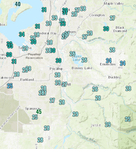
Lows dropped below freezing in most places, with upper 20s being common, especially away from the water.
Saturday night will be chilly, but not as cold as the night before. This is because a weather system will be moving in, bringing rain and breezy winds (20-30 mph).
As this weather system moves in, a strong pressure gradient (change) across the Cascades will bring strong winds through the gaps in the terrain.
The outlined areas will most likely experience increased winds (gusting 20-30 mph away from the foothills and 30-50 mph near the foothills).
Rain will move into the Puget Sound area by daybreak Sunday. The UW model forecasts 0.1-0.3 inches of rain through 4 PM Sunday.
That's not all. We'll get another 0.3-0.9 more inches of rain through Tuesday. Total rain through 4 PM Tuesday will be 0.6-1.3 inches.
I expect that we will receive even more rain through the end of the week and in to the weekend. We are in a La Nina pattern for this winter, which means we will have cooler and wetter weather, so this is going "as planned."
Since the rain will be associated with weather systems moving through, expect breezy winds through the week, with gusts of 20-30 mph likely.
There will also be a plentiful amount of mountain snow...with 12-18 inches at Snoqualmie and Stevens Passes. The snow level will be 2,000-3,000 feet.
Stay tuned for more information about upcoming weather systems and their impacts! We're not through with our stormy pattern yet...


No comments:
Post a Comment