It has been a rainy week in Western Washington. Our precipitation totals since Sunday (12/6) are below.
Totals of 0.6-1.7 inches since Sunday...and more is on the way. Notice the heaviest rain in the South Hill/Orting/Graham areas. Higher totals are due to stronger bands of rain being focused on a certain area.
Friday will be mostly dry, with a chance of rain in the afternoon/evening. I'd expect nothing more than scattered showers, with totals of 0.05-0.2 inches likely.
Friday will also be chilly, with highs in the low-mid 40s. With a slight chance of rain later on Friday and into early Sunday, and temperatures of 26-35 degrees Friday night/Saturday morning, a slight chance of rain/snow mix or "chunky rain" exists. This will be non-impactful, but keep it in mind.
Saturday morning lows are below. (Forecast from the European model).
Brrr! Be prepared for a chilly morning!
As we move through Saturday (partly sunny, low-mid 40s), a strong low pressure system will approach the Gulf of Alaska, while a high pressure ridge dominates the Intermountain West.
Outlined in the UW forecast model image below (valid 9 PM Saturday) are the high "H" and low "L" and the winds moving through gaps in the terrain (arrows).
Expect winds to gust 30-40 mph in areas that are prone to easterly winds (in and to the west of the red outlined regions). These winds will be strongest Saturday night into Sunday morning.
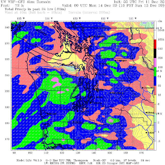
Guess what happens on Sunday? The return of rain (I'm sure you could've guessed). A frontal system will bring 0.2-0.75 inches of rain on Sunday.
The UW forecast model below shows rain from 4 PM Saturday-4 PM Sunday. Most (likely all) of this will fall on Sunday.
This is just the beginning. Expect a break on Tuesday, and then we are in store for a rainy and potentially breezy rest of the week.
I expect we will receive 1.5 to 6 inches of rain through the 20th.
In addition...(insert rejoicing skiers)...plentiful amounts of mountain snow are likely, with 1-3 feet of snow through the next 10 days.


No comments:
Post a Comment