Thursday featured some rain and occasionally breezy conditions across Western Washington. Winds will increase on Friday as a low pressure system skirts the coast, and showers will prevail for the next few days. Let’s get the details!
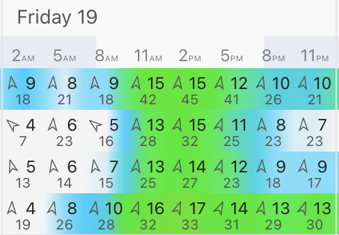
Friday will be windy. Take a look at the forecast below for Puyallup.
Winds gusting 30-45 mph are likely across the area, particularly from morning to evening on Friday. Expect winds to increase around or after 8 AM, peaking mid-afternoon, and decreasing through the night.
As always, some tree damage is possible, and be sure to secure objects that could be blown around by winds.
Taking a look at a longer-range forecast, expect showers through at least the middle of next week. (Puyallup forecast from Weather Underground)
Also notice the “chilly” high temperature on Sunday. We will likely stay below 50 degrees on Sunday, with near to slightly below average temperatures for the rest of the days.
Now to another weather event...there was a major tornado/severe weather outbreak on Wednesday across the Deep South. For the first time since 2019, the NOAA/NWS Storm Prediction Center issued a rare and dangerous high risk for severe weather. Wednesday’s severe weather threat map is below.
The red and pink colors (Moderate and High risks) are reserved for only the most dangerous events. An explanation of these risk categories is below.
You can see how the categories get progressively more dangerous, culminating with the high risk section. (The highest risk ever issued for Washington was an enhanced risk for severe thunderstorms in Eastern WA on May 30th, 2020.)
Below is a link to photos and information about Wednesday’s tornado outbreak. Please keep those impacted in your prayers.
https://weather.com/photos/news/2021-03-17-tornadoes-deep-south-photos
Be prepared for wind in Western Washington tomorrow!


No comments:
Post a Comment