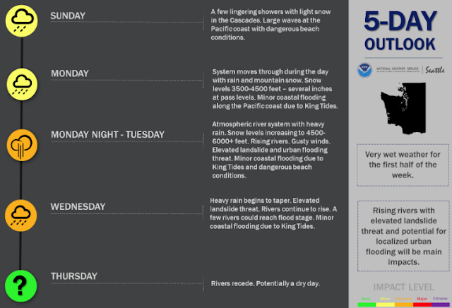
The second full week of 2021 will start off quite wet, with an atmospheric river set to impact Western Washington during the first half of the week. Let's take a look at the details.
This 5-day outlook from NWS Seattle shows what to expect in the coming days.
The UW forecast model has some great tools to see the strength of atmospheric rivers that impact the Pacific Northwest.
Below is the integrated water vapor transport (IVT). This is basically the measure of water vapor being transported in the atmosphere. The forecast below is for 1 AM Tuesday.
Yellows, reds, and dark blues are higher values (key at bottom of image). At this time (1 AM Tuesday), a true atmospheric river is aimed at the Pacific Northwest. You can see the area of dense moisture stretching across the Pacific Ocean to our shores.
There will be two surges of strong and deep moisture. One is Monday night/Tuesday morning, with the second coming early Wednesday. They are both shown below.
These are potent atmospheric rivers that will bring a lot of rain to Western Washington. In addition, snow levels will rise above pass level on Monday night, leading to rain (5-10 inches), snowmelt, and avalanche danger in the mountains.
The GFS Model forecasts around 3 inches of rain for Western Washington through Wednesday evening. Expect the heaviest rain from Monday evening to Tuesday morning.
3-5 inches of rain in the lowlands by the end of this week is a good ballpark estimate. This will cause urban & small stream flooding, a high landslide threat, and possible river flooding.
In addition to the rain, gusty winds are possible as well. Expect wind gusts of 20-40 mph Monday night into Tuesday morning.
More wind, potentially stronger, is possible on Wednesday. It looks like we will have a drier day on Thursday.
Any winds will be worth watching due to the saturation of the soils producing a higher probability of tree damage.
Stay tuned & stay safe!


No comments:
Post a Comment