FastCast—Thursday, Aug. 17 to Sunday, Aug. 20:
The longest and hottest heat wave of 2023 is coming to an end across Western Washington! High clouds, advancing marine air, and a weakening high pressure ridge will bring temperatures down a few degrees on Thursday, likely reaching the upper 80s to low 90s across the lowlands, except in the mid 80s around Olympia and Shelton, and in the low 80s from Everett northward (cooler near water). Overnight lows into Friday morning will drop to the upper 50s to low 60s across the region, with the densest urban areas remaining in the mid 60s one more time. Friday will bring refreshing near-normal temperatures, with highs reaching the mid 70s to low 80s. By Saturday morning, low temperatures will reach the low to mid 50s across the lowlands, the coolest temperatures in weeks! Winds will turn back offshore on Saturday, bringing highs to the upper 70s to low 80s and dropping relative humidity to the 30-40% range. Temperatures will increase on Sunday, with highs likely rising back to the mid to upper 80s in the lowlands, potentially into the low 90s in the foothills/mountain valleys. Lows on Sunday morning will rise back to the upper 50s to low 60s in the lowlands. Fire weather concerns will remain elevated on Sunday in the lowlands, with low relative humidity. There is a Stage 2 Burn Ban in King County. Please do not burn!
—————————————————————
Continue reading the full blog below!
We are almost to the end of the heat wave in Western Washington! Conditions will cool down in Eastern Washington as well, but that’ll take a bit longer. Additionally, fire weather concerns will be elevated on both sides of the state over the next few days. Let’s take a look at the forecast.
First, let’s look at highs on Thursday from the European model.
In the lowlands, expect highs in the upper 80s to low 90s, except cooler (in the mid 80s) north of Everett and around Olympia and Shelton, as marine air moves in. The Willamette Valley will be cooler as well, likely reaching the upper 80s to low 90s, ending Portland’s 4-day stretch of 100º+ highs. On the coast, temperatures will continue cooling, only reaching the mid to upper 60s. Eastern Washington will remain hot, with temperatures in the upper 90s to low 110s.
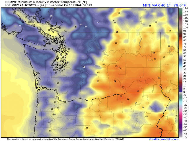
Noticeable cooling will occur overnight Thursday into Friday, as seen in the European model forecast below.
On Friday morning, expect lows in the lowlands and Willamette Valley to drop to the upper 50s to low 60s, except in the mid 60s for the densest urban areas. The coast will drop to the low 50s to low 60s, and Eastern Washington will remain mild, in the upper 60s to upper 70s.
Cooling will be quite noticeable on Friday. Below is the European model forecast for highs on Friday.
In the lowlands, expect seasonable highs in the mid to upper 70s. Isolated locations will reach the low 80s. The coast will reach the low to mid 60s, and the Willamette Valley will reach the low to mid 80s. Eastern Washington will remain hot, but highs will drop to the mid 80s to upper 90s.
The real refreshing conditions will be overnight Friday into Saturday morning, as seen in the European model forecast below.
Lows in the lowlands will drop all the way to the low to mid 50s! Some outlying areas will drop to the upper 40s. Meanwhile, Eastern Washington will cool to the mid 50s to mid 60s, a refreshing drop from previous overnight lows.
Temperatures will rebound a bit on Saturday, as seen in the European model forecast below.
Lowland highs will reach the low 80s, except the mid 80s around Olympia and Shelton. The Willamette Valley will reach the upper 80s to low 90s. Eastern Washington will reach the mid 80s to mid 90s, and the coast will reach the low 60s to low 70s.
Another aspect of the cooling trend will be an influx of onshore flow. This will accelerate westerly winds through gaps in the east slopes of the Cascades, bringing very dry conditions with low humidity across Eastern Washington. Due to this, the NWS Storm Prediction Center has designated a critical fire weather risk on Friday.
Notice a majority of Eastern Washington is in red, the critical category for fire weather. Other areas, mainly from the Cascades east, are also in the elevated (orange) category. This will likely continue on Saturday as well. Remember that with these conditions, it only takes a spark to start a huge fire.
Additionally, with fire weather conditions, expect relative humidity in the 10-15% range and winds gusting 25-35 mph, highest near Ellensburg and Wenatchee.


Thank you again for your weather report.
ReplyDelete