FastCast—Monday, Aug. 28 to Tuesday, Aug. 29:
Expect a thunderstorm-specific update on Monday afternoon! Stay tuned!
After highs reached the mid to upper 80s across Western Washington on Sunday, a significant pattern change is ahead. First of all, air quality will remain in the “moderate” to “unhealthy for sensitive groups” categories on Monday, with significant improvement to “good” on Tuesday. Temperatures will drop to the mid to upper 70s in the lowlands on Monday, and then drop further to the mid 60s to mid 70s on Tuesday, potentially the coolest day since June! This will be associated with a trough of low pressure moving inland, bringing a significant thunderstorm potential from Monday night to Tuesday morning, followed by showers through the day on Tuesday. The highest chance for thunderstorms in the lowlands is from late Monday night to early Tuesday morning, and this is also the best potential for heavy rain (0.3-0.7” possible within 6-12 hours). Rain amounts across the lowlands greatly depends on thunderstorm locations, with amounts of 0.1-0.8” in play, but the greatest likelihood for 0.25-0.75” through Tuesday evening. Continue reading below for more information and a breakdown of the thunderstorm potential.
——————————————————————
Continue reading the full blog below!
A noticeable pattern change is ahead for the Pacific Northwest over the next few days. The most significant features of this pattern change will be the removal of smoke by early Tuesday (in Western WA) and the significant thunderstorm potential from late Monday night to early Tuesday morning. Let’s take a look at the forecast!
First, we’ll look at the European Ensemble mean forecast for rain through late Tuesday.
This forecast shows 0.3-0.7” of rain along the I-5 corridor, with the most (0.5-0.7”) in the Cascades and from Eatonville northward. Areas with the heaviest precipitation amounts (blue, in this forecast) have the highest chance for thunderstorms. Eastern Washington will get less rain through late Tuesday, but stay tuned, as much more is expected there in the coming days.
We will now compare this to the GFS forecast, also showing total rain through late Tuesday.
The GFS has the heaviest rain (0.5-0.6”) for areas near Enumclaw northwest to Bellingham, with Tacoma and Olympia getting far less (0.1-0.3”) with thunderstorms staying to the east. This forecast also shows 0.3-0.5” of rain for parts of Eastern Washington.
Next, we will compare this to the high-resolution NAM forecast, also through late Tuesday.
The NAM, which is prone to overdoing heavy precipitation, shows thunderstorms tracking from Central Lewis County northwest to the Poulsbo area, going between Olympia and Tacoma, with additional thunderstorms in the Cascades and foothills, and in Eastern Washington. This forecast is essentially the European Ensemble’s forecast for the lowlands, just shifted west.
Finally, we’ll compare this to the UW WRF forecast through early Wednesday, seen below.
This forecast is an outlier, showing most rain & thunderstorms from I-90 northward, both in the lowlands and foothills/Cascades. This forecast gives 0.3-1.25” of rain under thunderstorms, with amounts likely a bit overdone.
One very important ingredient for thunderstorms is instability, which is measured in CAPE, which stands for Convective Available Potential Energy. Below is the CAPE index from the UW WRF model on Monday evening.
Notice elevated CAPE over the lowlands and parts of the Cascades. That is good news for thunderstorms.
We will wrap up this blog with a look at the significantly decreasing temperatures expected over the next few days. Below is the European model forecast for highs on Monday.
On Monday, expect lowland highs in the mid to upper 70s, coastal highs in the low to mid 60s, and Willamette Valley highs in the upper 70s to low 80s. Eastern Washington will remain quite hot, with highs in the mid 90s to mid 100s.
However, significant cooling is expected across the state on Tuesday, as seen in the European model forecast below.
On Tuesday, expect lowland highs in the mid 60s to mid 70s, coastal highs in the low to mid 60s, and Willamette Valley highs in the mid 70s. For most areas west of the Cascades, this will be one of the coolest days since mid June. Eastern Washington will cool to the mid 70s to upper 80s.
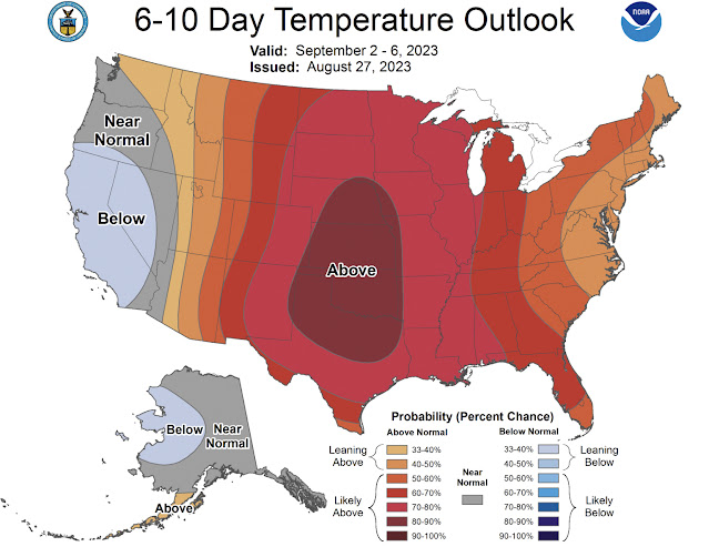
Let’s take a quick look at the extended temperature & precipitation outlooks from the NWS Climate Prediction Center for September 2-6.
This shows an equal chance of above or below normal temperatures for the SE half of Washington, and a 33-40% probability of above normal temperatures for the NE half.
The precipitation outlook for September 2-6 is below.
This outlook shows a 40-60% probability of above average precipitation for the entirety of Washington to begin September.
Remember, I will be posting a thunderstorm-specific update on Monday afternoon. Stay tuned!


No comments:
Post a Comment