FastCast—Thursday, Aug. 3 to Monday, Aug. 7:
Temperatures are slowly increasing across Washington, as a high pressure ridge builds northward into the Pacific Northwest. In the lowlands, expect mostly sunny conditions on Thursday, with highs in the low to mid 80s, hotter south of Seattle. Friday will be partly cloudy, with highs again reaching the low to mid 80s. Saturday looks to be hotter, with partly cloudy conditions and highs in the mid 80s, except slightly cooler near the water, and hotter (in the upper 80s to low 90s) south of Seattle. Sunday looks to be the hottest day in Western Washington, with highs in the mid to upper 80s, except cooler from Everett north. Conditions will be sunnier on Sunday, with more high clouds arriving on Monday, when highs will come down a few degrees to the low to mid 80s. Low temperatures will be quite warm the entire period, likely in the upper 50s to low 60s, potentially even warmer in urban core areas. The next blog post, on Friday, will be a specific forecast for Seafair Weekend! Stay tuned!
—————————————————————
Continue reading the full blog below!
Temperatures are on the rise across the state as high pressure builds toward the Northwest. Let’s take a look at the upcoming forecast.
First, the European model’s forecast for highs on Thursday, seen below.
Expect lowland highs in the upper 70s to low 80s from Seattle northward and in the low to mid 80s from Seattle southward. The coast will reach the mid to upper 60s, and Eastern Washington will reach the upper 80s to upper 90s, hottest in the Columbia Basin.
Next, the European model’s forecast for Friday, seen below.
Expect another day of highs in the upper 70s to low 80s from Seattle northward and in the low to mid 80s (potentially into the upper 80s) from Seattle southward. The coast will reach the mid 60s to low 70s. Eastern Washington’s highs will be interesting, with a potential for thunderstorms and clouds making high temperatures erratic. Friday’s highs could be anywhere from the upper 70s to low 90s depending on location. Clouds and storms will be the determining factor in high temperatures.
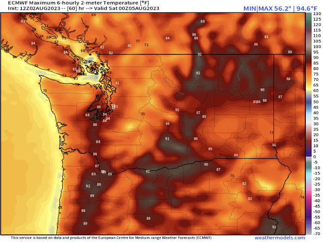
Continuing into Seafair Weekend (full Seafair forecast in Friday’s post!), below is the European model’s forecast for Saturday’s highs.
Temperatures look noticeably hotter. Expect highs from Seattle northward in the low to mid 80s, and in the mid to upper 80s (isolated low 90s) from Seattle southward. Eastern Washington will reach the upper 80s to upper 90s (potential low 100s). In contrast, the coast will be far cooler, likely in the mid to upper 60s.
Let’s take a look at an extended temperature forecast. Below is the European model’s forecast for highs and lows in the Seattle metro area over the next 10 days.
Generally, expect highs increasing through Sunday (peak), then cooling slightly into next week. Then, there are signs of a potential heat wave at the end of next week, but that is too far out to be certain of. Notice the forecasted low temperatures in this graph…lows will remain in the upper 50s to low 60s through at least next Friday, not giving much heat relief until just before sunrise, when temperatures reach their minimum.
Let’s take a look at this same graphic for the Tri-Cities, also a 10-day forecast from the European model.
This is the same general trend as Seattle, with the exception of the potential thunderstorms complicating highs on Friday. Otherwise, Eastern WA will have the same pattern of peak heat this weekend, a cooldown next week, and the potential for more heat late next week. Lows remain quite warm, in the upper 60s to low 70s.
Finally, this same graphic for the Washington coast, with the forecast shown for Hoquiam.
Coastal temperatures will peak on Friday, with cooler marine air arriving over the weekend and remaining through most of next week. Notice the upward trend in temperatures toward the end of next week. Lows on the coast will remain on the warmer side for this time of year, likely in the upper 50s to low 60s.
Finally, one more very important forecast…relative humidity. This is showing how much (or how little) water vapor is in the atmosphere. Below is the NAM high-resolution forecast for relative humidity at 4 PM Thursday.
Relative humidity will decrease to 35-45% for most of the lowlands, and all the way down to 10-20% for Eastern Washington. This only exacerbates the already dry conditions across the state. Remember that it only takes one spark to start a fire, whether in a forest or on the side of a highway. Please do your part to prevent any fires!
Stay tuned for a special Seafair Weekend forecast on Friday!


No comments:
Post a Comment