No FastCast tonight…continue reading the full blog below for a heat wave update. Scroll down further to find a forecast for specific cities.
Remember to stay hydrated, stay out of the sun at the hottest time of the day, and know the signs of heat exhaustion and heat stroke. If you suspect an emergency (for yourself or others), call 911!
To find cooling centers in Washington, dial 2-1-1 (business hours)or visit wa211.org (anytime).
Degraded air quality is possible at times through midweek. Air quality will be worst in mountain valleys near the Sourdough Fire in the North Cascades, near Diablo Lake. Air quality in the “moderate” to “unhealthy for sensitive groups” categories is possible across the lowlands.
Sunday was hot across the region, but Monday, Tuesday, and Wednesday will be hotter. Let’s take a look at the forecast.
First, highs on Monday, from the European model.
On Monday, expect lowland highs in the upper 80s to low 90s, cooler near the water. Areas on the Kitsap Peninsula and from Olympia west and south will reach the mid to upper 90s. The coast will reach the mid 80s to low 90s, except the beaches will remain in the mid 70s to low 80s. Eastern Washington will reach the upper 90s to upper 100s, and the Willamette Valley will reach the low to mid 100s.
Temperatures only get hotter on Tuesday, as seen in the European model forecast below.
On Tuesday, expect lowland highs in the upper 80s to low 90s again, cooler near the water and in the mid to upper 90s on the Kitsap Peninsula and from Olympia west and south. The coast will cool slightly to the upper 70s to mid 80s, except in the upper 60s to mid 70s at the beaches. The Willamette Valley will reach the low to mid 100s for a second straight day, and Eastern Washington will be scorching, with highs in the low 100s to low 110s.
Wednesday will be slightly different, but still very hot. Below is the European model forecast.
On Wednesday, expect lowland highs in the low to mid 90s from Seattle south and in the upper 70s (near water) to upper 80s from Seattle north. The coast will cool further to the mid 70s, and down to the mid 60s at the beaches. In the Willamette Valley, temperatures will “cool” slightly to the upper 90s to low 100s. Eastern Washington will remain very hot, with highs in the upper 90s to upper 100s.
Although the daytime high temperatures are rare and dangerous, nighttime low temperatures are arguably the most dangerous part of this heat wave, since there will be little overnight relief, especially in urban areas.
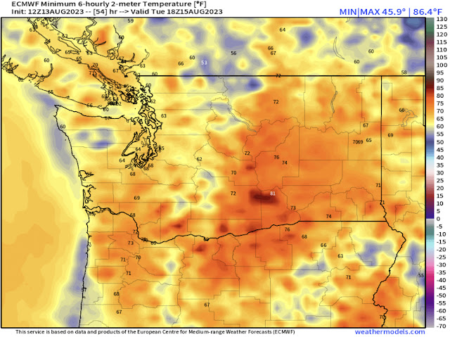
Below is the European model forecast for lows on Monday.
Overnight Sunday into Monday morning, expect lows across Western Washington to only drop to the low to mid 60s, potentially the upper 60s in the Seattle metro area. Eastern Washington and the Willamette Valley will remain in the upper 60s to low 70s.
Tuesday’s lows will be a tad warmer for non-coastal locations, as seen in the European model forecast below.
Overnight Monday into Tuesday, expect lows in Western Washington in the mid to upper 60s. This is quite high for our region, and can be dangerous for those suffering from heat exhaustion. Coastal lows will drop to the mid 50s to low 60s. Lows in the Willamette Valley and Eastern Washington will be in the low to mid 70s, with isolated Eastern WA locations remaining in the upper 70s to near 80º overnight.
Finally, Wednesday’s lows, also from the European model.
Overnight Tuesday into Wednesday, lows will again be in the low to mid 60s for the lowlands (potentially upper 60s for Seattle metro), but cooler marine air will be starting to move in. The coast will drop to the upper 50s to low 60s, and the Willamette Valley will drop to the mid to upper 60s (still very warm). Eastern Washington will remain very warm overnight, with lows in the low to mid 70s north of I-90, and in the mid to upper 70s (isolated areas in the low 80s) south of I-90.
One important note before city forecasts…it is very dry. The European model relative humidity map below for Monday afternoon shows how dry the entire region is.
Relative humidity in the lowlands drops to 30-45%, with the Cascades, Willamette Valley, and Eastern Washington all in the 10-20% range. This is prime time for fires to spark, and any spark can very quickly turn into an uncontrollable wildfire. Remember to do your part to prevent wildfires, and in turn prevent degraded air quality and smoke.
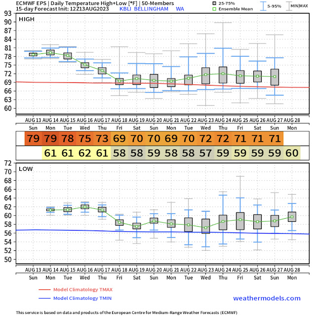
Now, we will examine multiple cities across the region and take a look at their forecasts from the European model ensemble (EPS). How to read this graphic: Top graph is high temperatures, red line is average. Middle large numbers are highs and lows, with days just above. Bottom graph is low temperatures, blue line is average, dates on bottom. Gray bars indicate range in ensemble members. Smaller bar = more certainty in forecast.
First, the Seattle metro area forecast (from SeaTac Airport).
It is likely that the Seattle area will reach 85º+ from Monday to Thursday, with a potential to reach the low 90s on Monday, Tuesday, and Wednesday. Lows will be quite warm, in the mid to upper 60s through Tuesday morning, then in the low to mid 60s through Friday morning.
Next, the forecast for Olympia, clearly hotter than Seattle.
Olympia has a good chance to reach the mid 90s on Monday and Tuesday, with a potential for highs reaching the upper 90s. Temperatures will remain in the mid 80s to low 90s through Thursday, with lows in the mid to upper 60s through Tuesday, then in the low 60s through Friday.
Next, heading much further north, notice how Bellingham (right on the water) remains much cooler.
Highs in the city of Bellingham will remain in the upper 70s to low 80s, with lows in the low 60s. Highs will slowly decrease to the low to mid 70s by Thursday. This is a classic example of areas immediately by the water being far cooler than 5-10 miles inland.
Next, the scorching forecast for Pasco.
Highs in the Tri Cities will be 100º+ through Thursday, with a run at 110º+ possible each day through Thursday. Temperatures will then cool to the low to mid 90s. Overnight lows will be in the upper 70s on Tuesday and Wednesday, dropping to the low to mid 70s through Friday.
Next, the similarly scorching forecast for Portland.
Expect Portland’s highs to reach the low to mid 100s on Monday and Tuesday, after already hitting 100º on Sunday. Temperatures will decrease to the mid to upper 90s on Wednesday and Thursday, then refreshingly to the low 80s by Friday. Lows will be in the mid to upper 60s through Thursday, then drop to the upper 50s/low 60s.
Finally, a couple cities on the coast, starting in Hoquiam.
Expect the north and central Washington coast to reach the upper 70s to mid 80s on Monday, then drop to the mid to upper 70s on Tuesday, then back down to the 60s for the remainder of the week. Lows on Monday and Tuesday will be in the mid 60s, significant for the coast, dropping to the mid 50s to low 60s after that.
Lastly, the forecast for Astoria.
The northern Oregon coast and southern Washington coast will reach the upper 80s to mid 90s on Monday, then the upper 70s to mid 80s on Tuesday, then back to the upper 60s to low 70s for the remainder of the week. Lows will be quite warm, in the mid to upper 60s, on Monday and Tuesday, then back in the upper 50s to low 60s for the rest of the week.
It is important to note that small differences in the strength of offshore winds can significantly increase coastal temperatures, even hotter than what these forecasts show. Also, highs at the immediate coast (the ocean beaches) will be 5-15º colder than these forecasts on Monday and Tuesday, but will still be uncharacteristically warm.
Stay safe, stay hydrated, and stay indoors during the hottest time of the day!


No comments:
Post a Comment