FastCast—Tuesday, Aug. 22 to Friday, Aug. 25:
As of Monday night, smoke has cleared out of Western Washington, with air quality returning to the “good” category for all areas except around North Bend. By early Tuesday morning, air quality will be good for the entirety of Western Washington! In Eastern Washington, air quality remains “unhealthy” to “hazardous” as of Monday night, except “good” to “moderate” near Spokane. On Tuesday, smoke will blow eastward and out of the state, so areas near Spokane will degrade again on Tuesday. Clearing will be slow, with air quality slowly improving through Tuesday across Eastern Washington, before becoming “good” by early Wednesday morning, except near active fires. Rain is expected on Tuesday for areas around the Spokane County fires, with 0.1-0.75” possible. Similar amounts are possible for the eastern half of Eastern WA. In Western Washington, rain is possible from late Tuesday through Wednesday morning, with a trace to 0.4” possible, with the highest likelihood of rain on the coast. Expect conditions in the lowlands to be partly cloudy on Tuesday, becoming mostly sunny by midday Wednesday, then sunny on Thursday, and finally cloudy then sunny on Friday. Highs will reach the mid to upper 70s on Tuesday and Wednesday, and the upper 70s to low 80s on Thursday and Friday. Lows will remain in the 50s.
Smoke Smothers Seattle, Sunday, Aug. 20: https://youtu.be/TYgeS2aombQ
———————————————————
Continue reading the full blog below!
Smoke has cleared most of Western Washington, with Eastern Washington’s clearing likely through the day on Tuesday, with full clearing by Wednesday!
Now, due to a weak trough offshore, rain is possible across the state, particularly near the Gray and Oregon Fires in Spokane County. Let’s take a look at the forecasts!
First, the European model ensemble (EPS) forecast, showing total rain through late Wednesday.

This forecast is more aggressive with lowland rain totals, and also shows rain that has already fallen in far SE Washington and Eastern Oregon due to the remnants of Tropical Storm Hilary. This forecast shows 0.2-0.4” of rain near the fires in Spokane County, and 0.1-0.4” in the lowlands. The coast will get 0.1-0.4” as well in this forecast.
Next, we’ll look at the GFS forecast for rain through late Wednesday.

This forecast is a polar opposite for Western Washington, showing a trace to 0.1”, with the lowlands remaining dry. However, it shows a healthy 0.4-1” over the fires in Spokane County, with 0.1-1.2” of rain across most of Eastern Washington, highest closer to the Idaho border.
Next, we will look at the high-resolution NAM forecast, showing rain through late Wednesday.

The NAM shows rain of a more showery variety for Western Washington, with a trace to 0.1” in the lowlands, and 0.1-0.3” on the coast and in the Cascades, with isolated higher amounts possible. However, this forecast also shows 0.5-0.8” over the Spokane County fires, and 0.2-1.2” for most of the eastern half of Eastern Washington.
Finally, the high-resolution UW WRF forecast, showing rain through Wednesday evening.

This forecast shows 0.1-0.3” of showers for the lowlands, and 0.2-0.5” for the Spokane County fires, with similar amounts from Walla Walla northward to the Canadian border, with even higher amounts (1-1.5”) possible in the mountains.
Overall, forecasts agree on rain around the Spokane County fires and parts of Eastern Washington on Tuesday, with a potential for showers in the lowlands from late Tuesday through Wednesday morning.
We will wrap up the blog by taking an extra close look at the European model ensemble forecast (EPS), showing the certainty of rain near the Gray and Oregon Fires in Spokane County.
First, the EPS forecast for Fairchild Air Force Base, close to the Gray Fire and the town of Medical Lake (SE of Spokane).
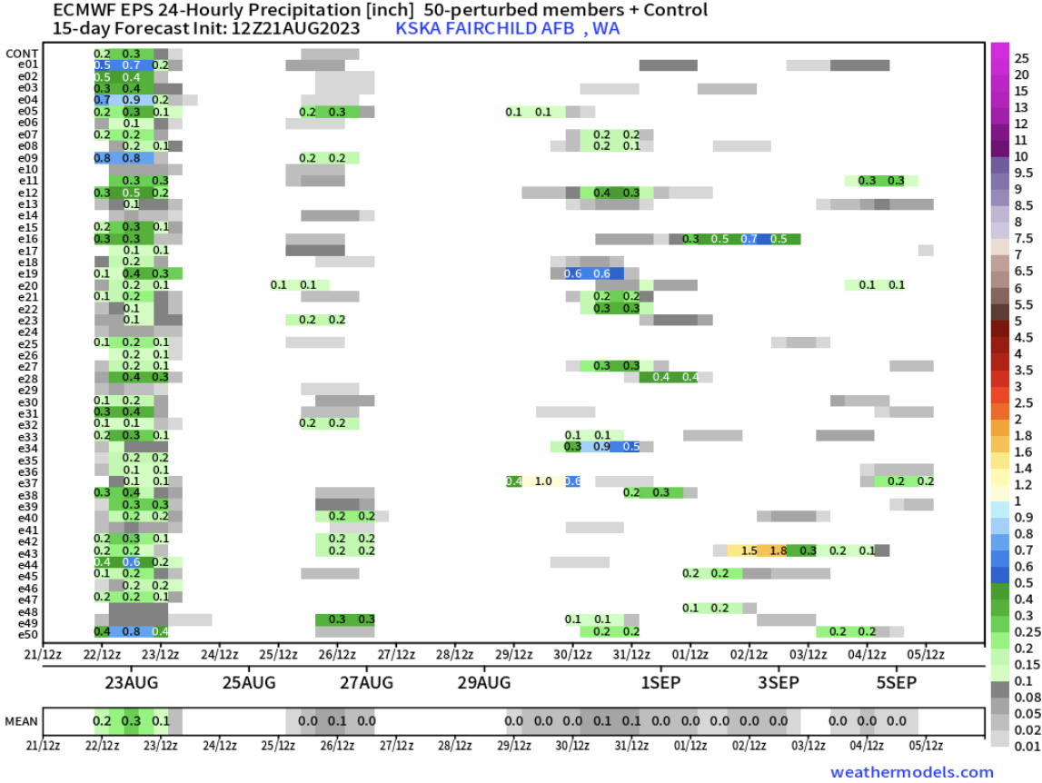
Notice the stripe on the left of this forecast showing a high probability among the ensemble members for rain from Tuesday to Wednesday, with amounts of 0.2-0.5” likely!
Next, the EPS forecast for Deer Park Airport, near the Oregon Fire in the town of Elk (north of Spokane).

There is an even higher probability of rain near the Oregon Fire, with this forecast showing a high possibility of 0.3-0.6” of rain from Tuesday to Wednesday. Even higher amounts, up to 0.75” are possible as well.
This rain will definitely help firefighters, by bringing higher humidity and much wetter conditions. Stay tuned on Pacific Northwest fire updates here:
Northwest Interagency Coordination Center (NWCC) Large Fire Information Page (updated daily)

No comments:
Post a Comment