FastCast--Saturday, Aug. 5 to Sunday, Aug. 6:
Seafair weekend is here! However, the weather is going to be more complex than the past few days. Monsoon moisture will move north into the Pacific Northwest this weekend, bringing showers, potential thunderstorms, more clouds, and cooler temperatures to the region. The best chance of showers will be from midmorning Saturday through early Sunday afternoon, with a potential for showers as early as Saturday morning. Any showers could have lightning, thunder, and brief heavy rain. Storms will be moving from east to west, off the Cascades. High temperatures will only reach the mid 70s to low 80s, warmest on Sunday. It will feel muggy at times, especially from midday onward. Overnight lows will remain in the low 60s for most of the region. It is important to note that forecasts for showers are still uncertain. If you are at Seafair, be prepared to take shelter (NEVER under a tree in a thunderstorm). Stay tuned to local meteorologists for more details (click the Twitter logo on the right side of the blog). Continue reading below for a detailed forecast for the weekend.
-----------------------------------------------------------------
A potentially active Seafair weekend is ahead, with interesting weather across the state. This blog will give the forecast for the weekend, mentioning both Seattle and the statewide forecast.
Let's start with the rain forecasts. First, the European model's rain forecast through late Sunday.
This forecast shows a potential for significant precipitation in parts of the state. For Seattle, it shows 0.1-0.3" of rain. Parts of the South Sound, specifically from Auburn to Olympia, could get up to 0.5". Showers and thunderstorms will bring 0.3-1.4" of rain across Eastern Washington.
Let's compare this to the European model ensemble forecast for rain over the next 15 days. We'll be paying attention to rain from August 5-7 (dates at bottom).
Notice that many ensemble runs are picking up on the potential for rain this weekend around Seattle.
Let's take a look at the NAM high-resolution forecast, also showing rain through late Sunday night.
This is a very interesting forecast, showing a totally different picture than the European model. The NAM shows showers over the lowlands in simulated radar images, but doesn't show it amounting to any precipitation, which is a possibility. This also shows the potential for areas of very heavy rain in Eastern Washington and the Cascades, up to 2-3 inches in the heaviest storms.
Remember, with significant uncertainty in the upcoming forecast, either the European model or NAM model forecasts are possible.
So, how much rain will fall during Seafair? That's a somewhat difficult question to answer, since forecasts vary. The best chance for showers during Seafair is on Saturday (most of the day) and on Sunday before midday.
Next, let's take a look at high temperatures, which will be much cooler than previous days.
First, the European model's forecast for highs on Saturday.
Expect lowland highs on Saturday to be in the low to mid 70s, but potentially up to the upper 70s to low 80s if there is less cloud cover. Eastern Washington will reach the mid 70s to low 80s, potentially warmer with less clouds.
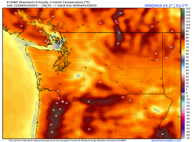
Below is the European model forecast for highs on Sunday.
Expect Sunday's highs in the lowlands to be warmer, in the mid 70s to the low 80s, potentially remaining in the low 70s near the water. Eastern Washington will reach the mid 70s to mid 80s, hottest around the Tri-Cities.
Finally, we will take a look at the potential for thunderstorms. With monsoon moisture, muggy conditions, and instability in the atmosphere, any shower could have the potential for lightning and thunder. A good measure of instability is the CAPE index, representing the amount of Convective Available Potential Energy (CAPE) in the atmosphere.
This is zoomed in to Western Washington for Saturday evening. Notice CAPE values of 100-400 over the Puget Sound area, but higher around Olympia and the Kitsap Peninsula. Thunderstorms are also likely in the Olympics and Cascades, which could lead to new fire starts.
Remember to stay tuned to reliable weather apps (like The Weather Channel, MyRadar, and FOX Weather) if you're out at Seafair. Additionally, click the Twitter icon on the top right of the blog to get updates from local meteorologists & weather enthusiasts.


No comments:
Post a Comment