No FastCast today…continue reading the full blog below.
A major smoke event is looking likely for nearly the entirety of Washington State, starting late Friday in Eastern Washington and early Saturday in Western Washington. This is due to offshore winds bringing smoke from fires in the Cascades and huge Canadian fires into Western Washington, and Canadian smoke being pulled straight south into Eastern Washington.
3 Important Reminders:
-In light of our recent heat wave, the best time to cool your house will be until around 7-8 AM Saturday morning in Western Washington. After that, air quality will be degrading and keeping your windows open will only draw in smoke
-Air quality will be significantly degraded across the entire state. Check statewide air quality below, and zoom in to your location for accurate hyper-local air quality information.
PurpleAir Washington State Air Quality Map
-By Saturday, air quality will likely be unsafe to be outside. If you are outside, wear a respirator mask. If you’re inside, either close your windows or use a box fan with a MERV 13 HVAC filter attached to it. If you are using air conditioning, a MERV 13 filter will filter out the potentially hazardous PM2.5 particles that come with smoke.
———————————————————————————
We will examine the HRRR smoke forecast to see the most likely scenario. All these graphics below show surface smoke only. Smoke aloft will be heavy over the lowlands before air quality begins to deteriorate.
First, the HRRR smoke forecast for 4 PM Friday.
On Friday evening, westerly winds are blowing off the ocean and pushing smoke plumes from fires in the Cascades and British Columbia eastward, with smoke impacting North Central Washington.
However, by 6 AM Saturday, winds have shifted, and smoke is being blown south and west, instead of east. The forecast for 6 AM Saturday is below.
With the wind shift, heavy surface smoke is present over most of Eastern Washington, with significantly degraded air quality likely early Saturday morning.
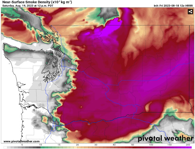
Then, smoke will begin making its way across the mountains and into Western Washington. Below is the forecast for 12 PM Saturday.
By 12 PM Saturday, Eastern Washington is fully entrenched in dense surface smoke, mainly from huge Canadian fires. Light surface smoke is present at this time across Western Washington, with moderate to heavy amounts from Everett northward and in the foothills. Smoke is also moving the the Columbia River Gorge toward Portland.
By 4 PM Saturday, the situation is getting worse.
By 4 PM, moderate to heavy surface smoke is present for the entire I-5 corridor from the Canadian border to the Willamette Valley. Smoke is still getting denser and heavier in Eastern Washington. At this time, only the coast from Ocean Shores southward is smoke-free, but that won’t last long.
This next graphic shows expected smoke at 9 PM Saturday.
Surface smoke is moderate to heavy across the entire state, with more very dense smoke pouring south from British Columbia. The coast now has moderate concentrations of surface smoke as well, even at the ocean beaches. By this time, air quality will likely be very unhealthy across the Puget Sound area.
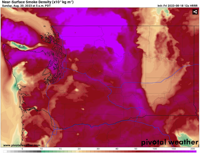
Finally, the forecast below for 5 AM Sunday, the limit of the HRRR smoke forecast (which runs for 48 hours).
This paints a very bad picture for Western Washington, with surface smoke levels potentially worse than October 2022 and nearly on par with September 2020. By this time (5 AM Sunday), heavy surface smoke is present across the entire state, from Eastern Washington, through Puget Sound, and all the way to the ocean beaches.
With the length of the forecast model, it’s a bit of a cliff-hanger ending for this post, but significant winds to clear the smoke aren’t likely on Sunday. We have some potential to clear some smoke out of Western Washington on the second half of Monday, but that remains to be seen, so stay tuned.


No comments:
Post a Comment