FastCast—Tuesday, Aug. 1 to Saturday, Aug. 5:
After a very pleasant and mostly dry July, similar weather will continue for the start of August. In the lowlands, expect mostly sunny skies on Tuesday and Wednesday, with highs in the upper 70s to low 80s and lows in the low to mid 50s. High clouds will move through the area on Thursday and Friday, but temperatures will be on the rise. Expect lowland highs increasing to the low to mid 80s, with lows increasing to the upper 50s. Saturday is looking to be on the hot side, with highs increasing further to the upper 80s, with lows in the upper 50s to low 60s. This will set the stage for a hot Seafair weekend in Seattle. Stay tuned in the next couple days for more information!
——————————————————————
Continue reading the full blog below (and check out the new weather graphics)!
July’s pleasant and near-average weather will continue into August. Let’s take a look at the forecast.
Below is the European model forecast for highs on Tuesday.
Expect lowland highs in the upper 70s to low 80s, with isolated areas reaching the mid 80s, mainly south of Tacoma. Eastern Washington will reach the upper 80s to upper 90s, and the coast will reach the low to mid 60s.
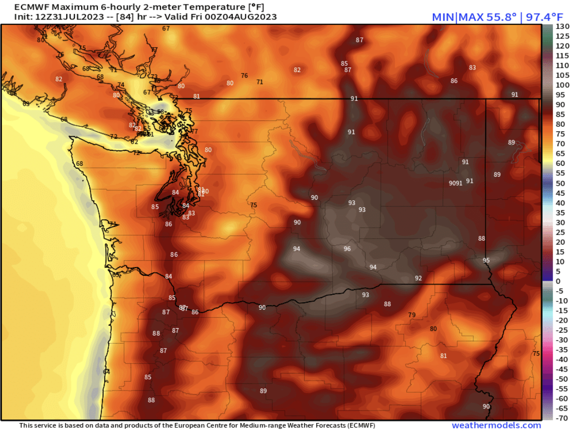
Similar seasonable weather is expected on Wednesday, also seen on the European model forecast.
Again, lowland highs will reach the mid 70s to low 80s. Eastern Washington will heat up even more, likely reaching the upper 80s to low 100s. The coast will remain in the low to mid 60s.
Temperatures will begin inching upward on Thursday in Western Washington, as seen in the European model below.
Expect Thursday’s highs to reach the upper 70s to mid 80s, hottest from Seattle southward. Eastern Washington will be a tad cooler, with highs mainly in the low to mid 90s. The coast will be a bit warmer, with highs in the upper 60s to low 70s.
Now, it’s time to introduce a couple new products to the blog, from the great weathermodels.com site! Below is a graphic showing Seattle’s highs and lows for the next 10 days from the European model.
How to read this: Big numbers are high & low temperatures, blue bars on the graph are high temperatures, green bars are low temperatures, and the date and day are on the bottom. The station that the graphic is for is in the top center, in blue, “KSEA (Sea-Tac Airport)/Seattle Metro” in this graphic.
This graphic will be frequently used on this blog for different locations across the state. The key takeaway with this European model forecast is to show that a warm Seafair weekend is expected, per this forecast, with highs in the mid 80s.
Let’s compare this to the GFS (American) model forecast.
Note: The GFS forecast in this type of graphic will always be 15 days, instead of 10 days for the European model, but forecast skill decreases by the end of that 15-day range.
The GFS forecast is much warmer than the European, showing highs in the mid 80s from Tuesday to Friday, then in the upper 80s to low 90s on the weekend. Both this forecast and the previous one are possible, and the exact outcome will become more clear in the coming days.
Finally, one more new graphic that will also be frequently shown on the blog. This is the European model ensemble forecast. Major forecast models run an ensemble forecast, which manipulates the initial weather conditions slightly in 30-50 different “members” of the ensemble. In this graphic, all 50 European model ensemble members are put together to show when rain is next expected, and how much rain is possible. Dates are on the bottom, and the bar beneath the dates is the average of all the ensemble members. This forecast is for Seattle.
What this forecast is showing is that there is a good potential for precipitation beginning late on August 8th (next Tuesday), with a near-zero likelihood of precipitation before then. We will continue to monitor our next precipitation potential in the coming blogs!
Stay tuned for more information on a hotter period ahead, potentially coinciding with Seafair weekend!


I like the new graph, it is easy to see what is coming in the days ahead.
ReplyDelete