FastCast—Sunday, July 30 to Wednesday, Aug. 2:
A seasonable end to July is ahead for Western Washington, with highs very near average (around 79º). On Sunday and Monday, expect lowland highs in the mid to upper 70s and lows in the low to mid 50s. Clouds will decrease throughout the day on Sunday, as well. A slow warming trend will begin on Tuesday, with highs increasing to the upper 70s to low 80s. Wednesday will likely be warmer, with highs further increasing to the low to mid 80s. Lows will increase to the mid 50s. Potential for more warming remains later next week, including Seafair Weekend, so stay tuned!
——————————————————
Continue reading the full blog below!
Pleasant summer weather will continue across Washington in the coming days. Let’s take a look at the forecast!
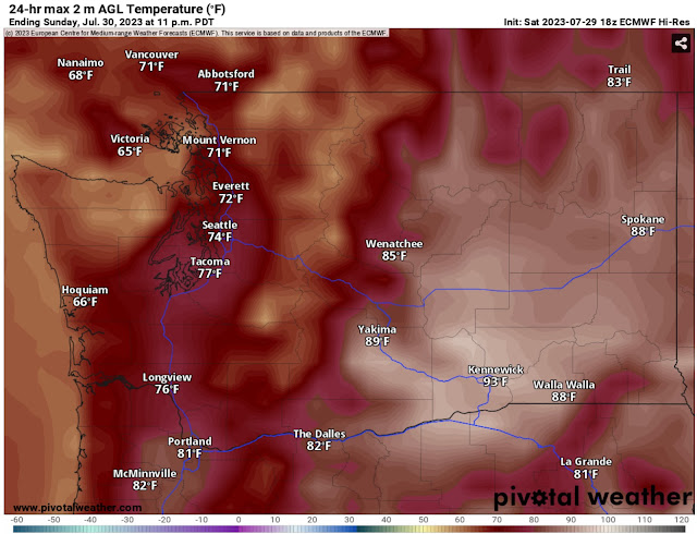
First, the European model forecast for highs on Sunday, seen below.
On Sunday, expect lowland highs in the low to mid 70s, Eastern Washington highs in the mid 80s to low 90s, and coastal highs in the mid 60s.
A similar situation will continue on Monday, as seen in the European model forecast below.
On Monday, expect lowland highs in the low to mid 70s (isolated areas in the upper 70s), Eastern Washington highs in the mid 80s to mid 90s, and coastal highs in the mid to upper 60s. There is a slight increase from Sunday in most areas.
Temperatures continue slightly increasing on Tuesday, seen in the European model forecast below.
Notice that temperatures have increased a bit more, reaching the mid 70s to low 80s in the lowlands. Eastern Washington has increased to the upper 80s to upper 90s, and the coast has increased to the mid 60s to low 70s. This looks to be the start of a slow warming trend through the first week of August.
One thing that will continue to be missing from our pattern is rain. Below is the European model forecast showing total rain through Tuesday night.
Very spotty and light areas of rain are possible, confined to the mountains and possibly a trace of drizzle along the coast. No rain is expected for the lowlands, Columbia Basin, or any other significant populated areas of Washington.
Finally, let’s take a look at the extended outlooks from the NWS Climate Prediction Center (CPC).
First, the temperature outlook for August 4-8, seen below.
This outlook shows a 50-70% probability of above-average temperatures across Washington, including the dates of Seafair Weekend. Stay tuned as we get closer!
Next, the precipitation outlook, also for August 4-8.
This is an interesting outlook, showing an equal chance of above or below average precipitation along the coast and Olympic Peninsula, and a 33-50% probability of above average precipitation for the rest of Washington. In Eastern Washington and the Cascades, this precipitation would likely be in the form of thunderstorms (or strong showers).
Stay tuned in the coming days as we get closer to Seafair Weekend and a potential increase in temperatures!


No comments:
Post a Comment