FastCast—Friday, May 27 to Wednesday, June 1st:
What a muggy day! Highs reaching the upper 60s around the region on Thursday combined with light rain and thick cloud cover, and dewpoints reached the upper 50s to low 60s! It is an example of the weather that does not often occur in the Pacific Northwest, but is common in other parts of the US. Quite a change is in store for Friday. High temperatures will drop around 10 degrees, only reaching the upper 50s to near 60 from Friday through Sunday. The majority of the weekend rain will fall from Saturday afternoon to Sunday morning, with showers expected at times on Friday and Sunday afternoon, as well. In total, from Thursday to Sunday, expect 0.75 to 1.25 inches of rain in the lowlands, 1-2 inches on the coast, and 2-3 inches in the mountains. On Monday (Memorial Day), temperatures will warm into the low to mid 60s, with mostly cloudy conditions. Nicer and warmer conditions will prevail on Tuesday and Wednesday, with partly sunny conditions and highs in the mid 70s!
——————————————————
Continue reading the full blog below!
After a muggy day on Thursday, a rainy Memorial Day Weekend is ahead. The European model forecast is below, showing rain through Monday morning.
Expect 0.75 to 1.25 inches of rain around the lowlands, with the most on Saturday and Sunday. The coast will receive 1-2 inches, and the mountains will receive 2-3 inches. This will be quite a wet end to an abnormally wet month.
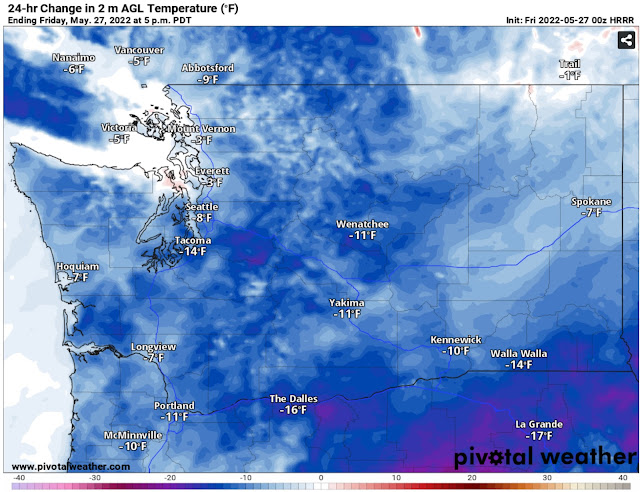
The temperatures on Friday, Saturday, and Sunday will be around 10 degrees below average. Specifically, Friday’s highs will be much cooler than Thursday’s highs. The change in temperature from Thursday to Friday is seen below in the HRRR forecast.
Temperatures will be 5-15 degrees cooler in Western Washington. Chilly highs in the upper 50s to low 60s will remain through Sunday.
A warmup is in store to start June! Let’s start with the 6-10 day temperature outlook, for June 1st-5th, seen below.
For the first time in a long while…there is a chance of above average temperatures in the Pacific Northwest!
What about actual highs? Take a look at the NWS National Blend of Models (NBM) forecast for highs on Wednesday, June 1st.
As of Thursday night, the forecasts have been hovering between 75 and 78 degrees for the lowlands (slightly cooler near the water, as seen above). Areas in the SW Interior (Olympia area), SW WA, the Willamette Valley, and Eastern Washington will have temperatures reaching the upper 70s to low 80s. Western Washington is still in search of the first 80+ degree day of 2022.
Stay tuned for more information about the nice weather to start June!


No comments:
Post a Comment