FastCast—Thursday, May 12 to Sunday, May 15:
After a few nice days, with highs in the upper 50s to low 60s, another round of spring rain is ahead, continuing the abnormal pattern that has brought above normal rain to the Northwest this month. Rain is moving onshore Wednesday evening, and a rainy day is expected on Thursday. Expect a break on Friday, with a chance of scattered showers. Rain will return on the weekend, with predominantly rainy conditions on Saturday and Sunday. Totals from Wednesday to Sunday will likely be 0.5 to 1 inch in the lowlands, 1-2 inches in the foothills and Cascades north of Mt. Rainier, and 2-3.5 inches on the coast and in the Olympics and South Cascades. Thursday’s temperatures will be over 10 degrees below normal, with lowland highs topping out in the low 50s. Temperatures increase through the weekend, with highs expected to be in the upper 50s to low 60s, despite the rain. Expect lows in the 40s, except in the upper 40s to low 50s on Saturday night. Some mountain snow is possible as well, mainly on Wednesday and Thursday, when snow levels are lower. The most snow (12-18”) will fall above 6,000 feet in the Cascades and Olympics. Only light amounts will fall at the Passes.
—————————————————————
Continue reading the full blog below!
The abnormally wet May pattern continues in the Pacific Northwest, with more systems ahead to end the week, continuing through the weekend.
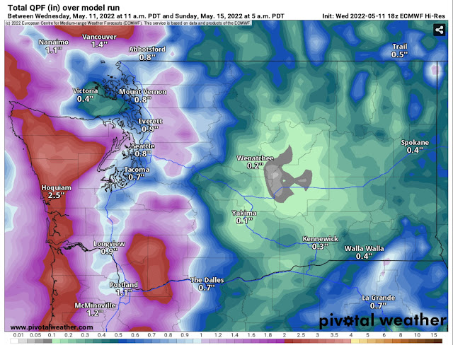
The European model below shows rain through Sunday morning.
This will be another significant round of rain, with the lowlands receiving 0.5 to 1 inch of rain, with 1-2 inches in the Cascades and 2-3.5 inches of rain on the coast and in the Olympics.
Another significant abnormality is the continued mountain snow. Light snow will fall at the Passes, with significant snow at higher elevations, with 12-18 inches above 6,000 feet, as seen below in the European model.
Thursday will be a significantly below average day, with high temperatures in the lowlands only in the low 50s, seen in the NAM model below.
This next image shows the temperature departure from average on Thursday, from the European model.
These are significantly below average temperatures, likely 10-15 degrees below average for the lowlands, more on par for late February or early March.
Remember the plus side…an increased snowpack and wetter spring will delay wildfire season and increase the summer water supply.


No comments:
Post a Comment