FastCast—Tuesday, May 10 to Friday, May 13:
May has been wet and chilly so far. Rain totals have been well above normal for most of Western Washington, with SeaTac Airport recording 1.94” as of Sunday, above the monthly normal of 1.88”. Rain will continue, along with below average temperatures. However, there will be a short break, with partly cloudy conditions and highs in the upper 50s to low 60s on Tuesday and Wednesday. Rain returns again late Wednesday, with a cold and rainy day expected on Thursday. Highs on Thursday will only reach the upper 40s to low 50s. Showers are possible, but not likely on Friday, with highs rebounding into the upper 50s and mostly cloudy conditions. Rain totals through Friday will be 0.4 to 1.25 inches in the lowlands, with the most in the foothills and around Everett. The coast and mountains will receive 1-3 inches. Expect lows in the entire period to be chilly, in the low to mid 40s, about 5 degrees below normal. There will also be some light snow at the passes, and mountain snow will continue at 6,000+ feet.
————————————————————
Continue reading the full blog below!
What an interesting month so far…May’s rain has already gone above average, and all but one day has had temperatures below average. These trends will continue. As average temperatures increase into the mid 60s, our temperatures have been stubborn, having a very hard time getting above 60 degrees.
Let’s start with the rain that is coming up. The European model below shows rain through Friday morning.

Expect most of this rain to fall from late Wednesday through Thursday night. The lowlands pick up 0.4-1.25 inches, with the most in the foothills and near Everett. The coast and mountains will receive 1-3 inches. Some locations in the lowlands could have monthly totals up to 3 inches by the end of the week!
Some mountain snow will continue as well, with light amounts (non-impactful) at the Passes, and more (6-12 inches) above 6,000 feet. See the European model below for snow through Friday morning.

Regarding temperatures, expect them to remain below average for the foreseeable future. The European model below shows Thursday’s high temperature departure from average. The entirety of Washington and Oregon are below average.
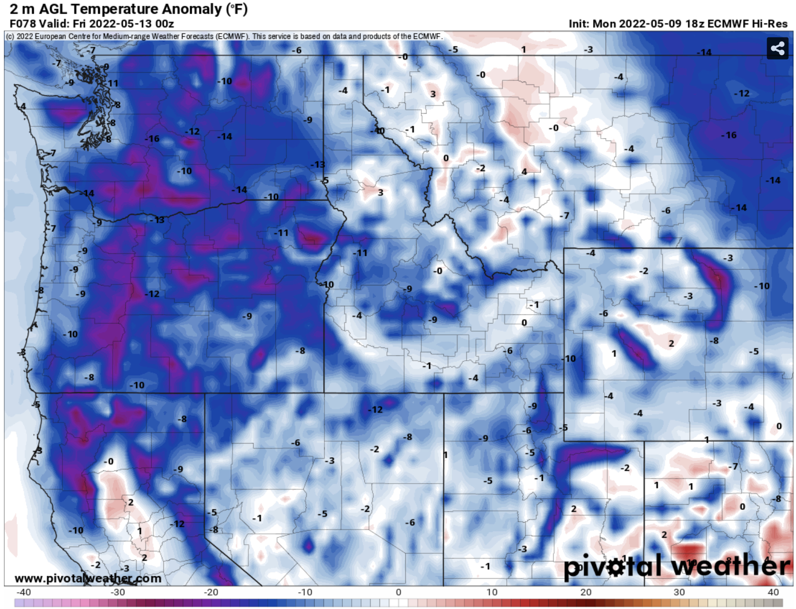
Thursday’s highs in the lowlands will be in the upper 40s to low 50s, up to 5-15 degrees below average. That same trend is reflected around the Pacific Northwest.
The NWS Climate Prediction Center maps for temperature and precipitation (valid May 15-19) show that the Pacific Northwest will most likely continue having below average temperatures and above average precipitation through the middle of the month.

While this may be dismal to some, the positive side is that the snowpack continues to build, our water supply is still increasing, and water worries this summer are virtually guaranteed to not happen.

No comments:
Post a Comment