No FastCast tonight…keep reading below for the next snow chances.
After a system brought snow to most of the lowlands early Sunday, another weak system will bring a chance of snow to parts of the region again on Monday. Again, this will be a marginal system, so rain/snow mix and sharp snow cutoffs are possible. The highest chance of snow is through Monday morning, while temperatures are still near freezing.
Let’s start with the European model’s forecast through 4 PM Monday.
The European model shows 0.2-1.5” of snow for the lowlands, with 1-3” on the North Coast and near Hood Canal. Areas in SW WA and Portland could get 1-2” in this situation, and the mountains get 6-10”.
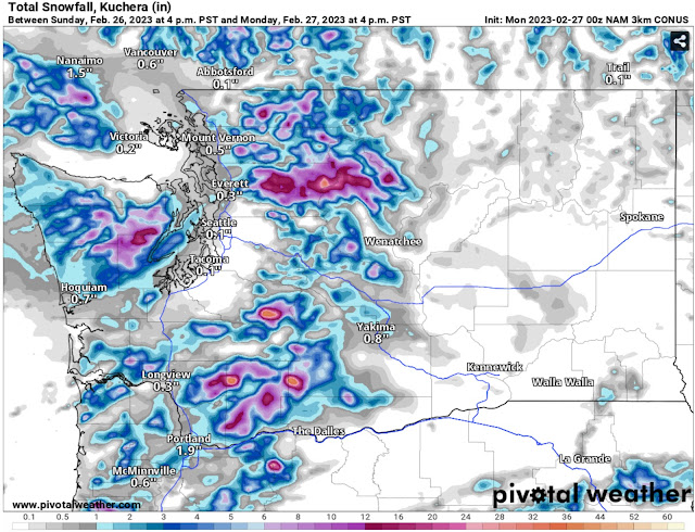
Next, the NAM high-resolution forecast through 4 PM Monday.
The NAM shows little snow from Olympia to Everett, but 0.2-1” from Olympia south and from Everett north, with higher amount of 1-3” on the North Coast and 3-6” near Hood Canal. This shows 1-3” of snow at the passes, diminishing possible impacts.
Next, the HRRR high-resolution forecast, also through 4 PM Monday.
The HRRR shows 0.5-1” of snow scattered around the lowlands, mainly from Olympia to Mount Vernon, with 2-4” around Portland and 1-3” on the North Coast. This shows 3-6” at Snoqualmie Pass and 6-12” at Stevens Pass.
Finally, the UW WRF high-resolution forecast, through 4 PM Monday.
The UW forecast shows 1-4” of snow from Tacoma south and on the Kitsap Peninsula, with some areas of 0.5-1” from Everett to Bellingham, plus 1-3” on the North Coast. This forecast gives the passes 1-6”, with more at Snoqualmie and White Passes.
So, putting this all together:
Everett to Vancouver BC: 0-1”
Olympia to Everett: 0-2”
Olympia to Portland: 0.25-3”
Coast from Hoquiam to Cape Flattery: 1-4”, more away from the ocean
Hood Canal Area & Kitsap Peninsula: 1-4”, isolated 4-6” near Hood Canal
Passes: 1-8”
Another chance of snow is expected from late Monday to Tuesday. Stay tuned to the next blog!


No comments:
Post a Comment