No FastCast today. Continue reading the full blog below.
A complex snowstorm forecast is ahead for late Saturday night through Sunday morning. Temperatures will be marginal, with snow amounts varying across the region. Let’s take a look at some forecasts and why this event is so marginal.
-Temperatures are above freezing, and will only go below freezing due to evaporative cooling, where precipitation falling through the atmosphere brings cooling.
-With marginal temperatures, precipitation may stay as rain/snow mix or all rain for some areas.
-Temperatures will quickly warm up early Sunday morning, with a changeover to rain possible before sunrise.
First, let’s look at the European model, shown below through 10 AM Sunday.

The European model forecast shows 0.5-1.5 inches for most of the lowlands from Olympia to Skagit County. Whatcom County will likely pick up 1-3”. The snow winners with this system will be areas along Hood Canal, the Kitsap Peninusla, and areas from Olympia south to Clark County, which will all get 2-6”. Areas will be snow-shadowed NE of the Olympic Peninsula and in Pierce & SE King Counties.
Next, the ultra high-resolution UW WRF model, showing total snow through 10 AM Sunday.
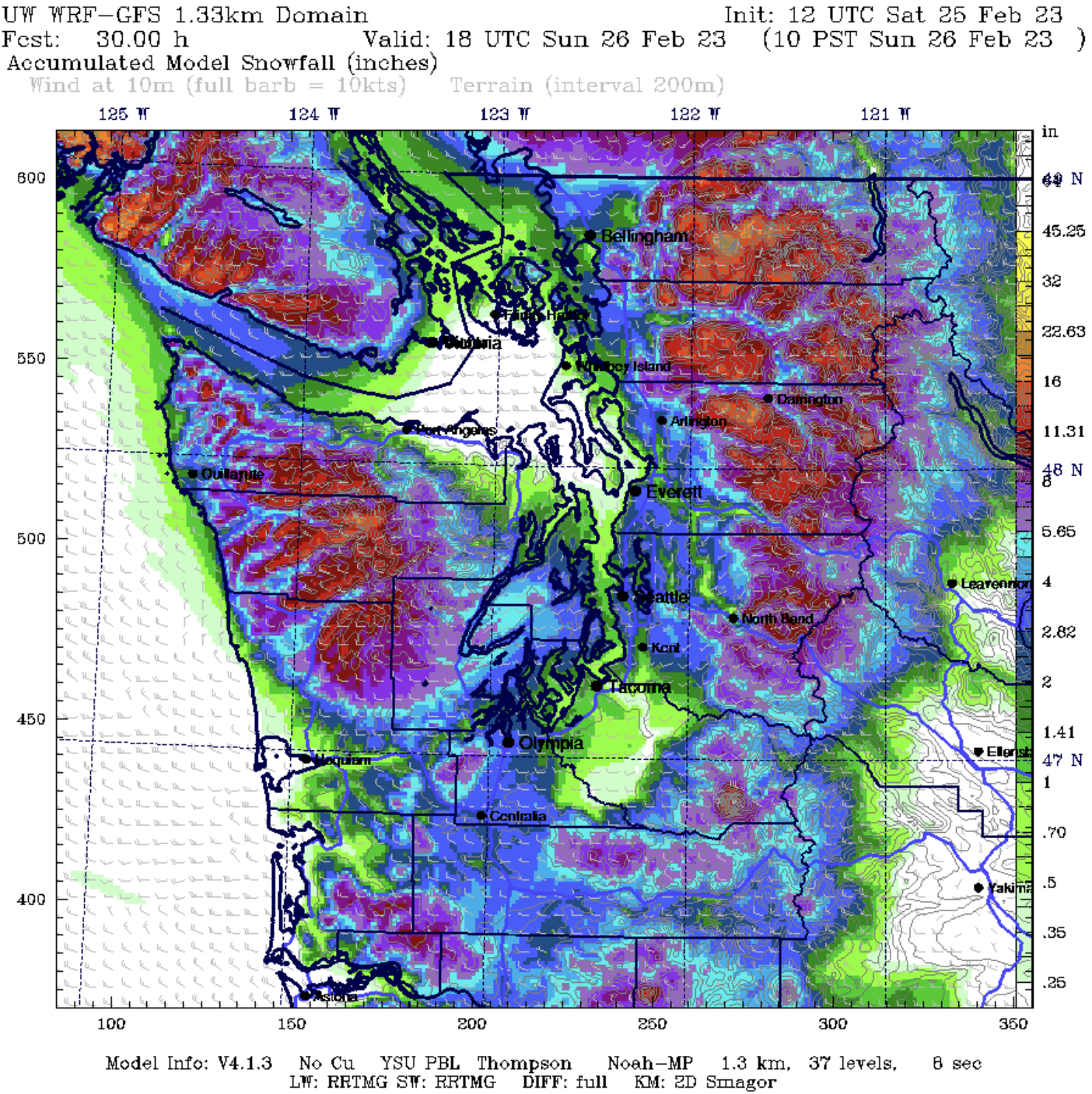
The UW WRF forecast shows roughly the same as the European, with snow shadows NE of the Olympic Peninsula and for Pierce County. This forecast is a bit snowier, with most of the lowlands picking up 1-3”, with isolated totals up to 4”, mainly in the foothills and from Everett northward. The Hood Canal area, Kitsap Peninsula, and areas from Olympia south to Vancouver get 4-6” in this snowier scenario.
Next, the NAM high-resolution forecast, also through 10 AM Sunday.
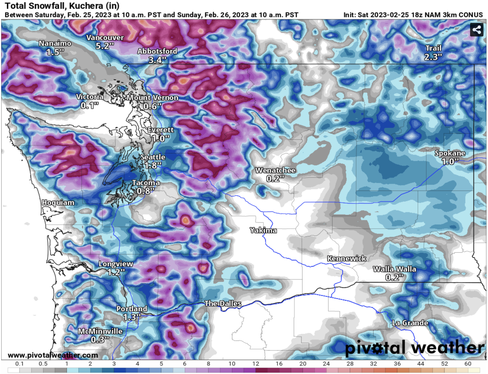
The NAM shows a less snowy scenario for most of the region, except a band from the Kitsap Peninsula to the Snoqualmie Valley, where it shows 2-4”. The NAM has a pronounced snow shadow for South King & Pierce Counties and areas along the Strait, Whidbey & Camano Islands, and Western Skagit County. Areas from Olympia south to Portland get 1-3”, and Hood Canal/Kitsap Peninsula win with 3-6”.
Finally, the HRRR high-resolution forecast through 10 AM Sunday.

The HRRR shows a very snowy forecast, with snow shadowed areas in Island and Pierce Counties getting a trace to 0.5”, and most other lowland areas getting 1.5-4”. This forecast shows the Kitsap Peninsula and Hood Canal areas getting 6-8”. This is an outlier and is generally unlikely to happen.
Putting this all together into one forecast:
Whatcom County: 1-4”
NE Olympic Peninsula Rain Shadow Area: 0-0.5”
SeaTac to Skagit County: 0.5-3”
SeaTac to Olympia: Trace-2”
Olympia to Portland: 1-4”
Hood Canal Area/Kitsap Peninsula: 2-6”, isolated 6+”
More marginal snow events are possible in the coming days, including residual snow-producing showers later on Sunday. Stay tuned! (Twitter link in top right of blog…frequent updates!)

I like your forecast better then the local news report. No rain or snow here yet, it is just before 10:00 pm, suppose it is on the way.
ReplyDelete