No FastCast tonight…continue reading the full blog below for an update on the rain and flooding forecast for the atmospheric river.
A significant atmospheric river is impacting the Pacific Northwest, with heavy rain, river flooding, and urban flooding expected. Rain will be steady (heavy at times) on Tuesday, slowly tapering off through the day Wednesday. Let’s take a look at the forecasts.
Additionally, subtropical moisture related to this atmospheric river will bring warm temperatures to the region (the lowlands reached the upper 50s to low 60s on Monday), with the mid to upper 50s continuing on Tuesday.
Let’s start with the European model’s forecast for total rain through Wednesday evening.

This forecast shows 2-3” for the lowlands, with less in the rain shadow NE of the Olympics (1-1.5”). The coast gets 2.5-4”, with the Willamette Valley getting 3-4”, and Eastern WA getting 1-2.5”. The Cascades and Olympics will get 5-8”.
Let’s compare this to the GFS (American) model, also showing total rain through Wednesday evening.
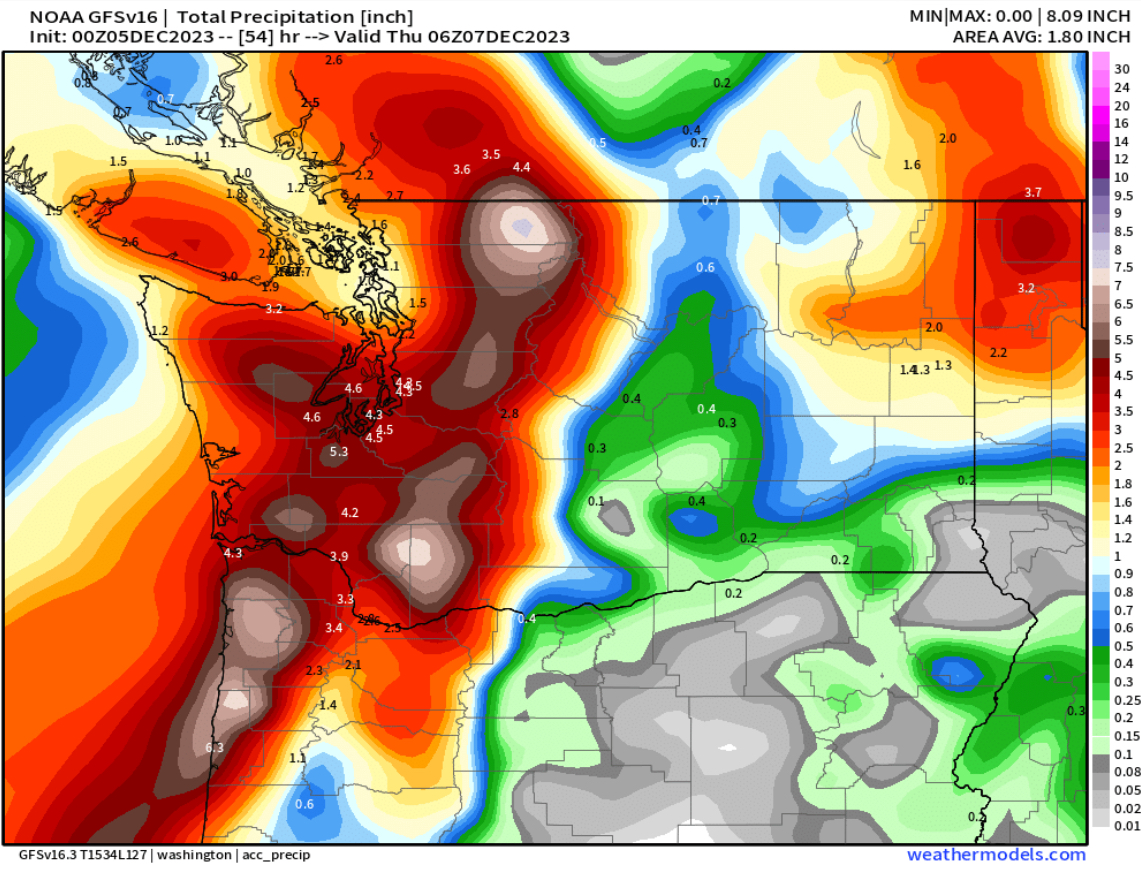
This forecast is much wetter, showing 4-5” for the lowlands, except less in the rain shadow (1-1.5”), which is poorly defined in this forecast. The coast and Willamette Valley get 1.5-3”, along with parts of Eastern WA. The mountains across the region get 5-7” in this forecast.
Now, we will look at high-resolution forecasts, focused specifically on Western Washington. First, let’s take a look at the NAM high-resolution forecast through Wednesday evening.

The NAM forecast shows 3-3.5” for the lowlands, with isolated areas getting up to 4”. A very pronounced rain shadow is seen from Everett northward and westward (0.25-1.5”). The mountains could get up to 10” of rain in this forecast.
Next, the UW WRF forecast for Western Washington, showing rain through Wednesday evening.

This forecast is very similar to the NAM, showing over 3” of rain from Seattle southward, with 1.5-2.5” from Seattle north, excluding the rain shadow area (0.3-1.25”). The mountains will get 3-10” in this forecast.
The last forecast we’ll look at is the HRRR high-resolution forecast, which doesn’t go as far, only to Wednesday afternoon, seen below.

The HRRR forecast shows 2.5-3” for the lowlands, 3-4” for the foothills, and a relatively large rain shadow NE of the Olympics (0.7-1.5”). The mountains get up to 10” in this forecast as well.
Now, let’s take a look at the NWS Weather Prediction Center (WPC) Excessive Rainfall Outlook for Tuesday (Dec. 5).

This shows a Moderate risk (40% chance) of flash flood conditions on the Olympic Peninsula, with a Slight risk (15% chance) for the coast, Cascades, and lowlands from Seattle southward. A Marginal risk (5% chance) exists from Seattle northward in the lowlands.
Finally, let’s take a look at river flooding potential, shown below from the NWS Advanced Hydrologic Prediction Service forecast.

Yellow is bankfull stage, which many rivers will reach, including the Nooksack, White, Cedar, Puyallup, Willapa, and Issaquah Creek. Orange is minor flood stage, which the Carbon, Stillaguamish, and Bogachiel will reach. Red is moderate flood stage, which the Skykomish, Chehalis, Neuwakum, Cowlitz, Nisqually, and Skokomish, will reach. Magenta is major flood stage, which the Snoqualmie/Snohomish and Skagit Rivers are expected to reach.
Remember that in addition to river flooding, these large amounts of rain within a short timeframe will bring urban flooding, water over roadways, and flooding in creeks and small streams. Remember to “turn around, don’t drown” and to not drive through flooded roadways. Stay tuned for further updates!

No comments:
Post a Comment