FastCast—Monday, Jan. 1 to Thursday, Jan. 4:
A calm New Year’s is expected for the Pacific Northwest, with mostly cloudy conditions and no rain. Lowland temperatures for midnight festivities will be in the upper 30s to low 40s, with calm winds. On New Year’s Day, expect mostly cloudy conditions, with highs in the mid 40s and lows in the low 30s. Tuesday will bring a weather system, with 0.2-0.5” of rain in the lowlands, and up to 6” of snow at the passes. Wednesday and Thursday will be mostly cloudy, with another system slated to impact the area from late Thursday through Friday. From Tuesday to Thursday, expect lowland highs in the mid to upper 40s, with lows in the upper 30s to low 40s.
————————————————————
Author’s Note:
I want to thank all of the readers of my blog for following along this year! It was a good year, and I enjoy writing blogs for you all. Happy New Year!
-Matthew
————————————————————
Continue reading the full blog below!
A cool…but not cold…New Year’s is expected for the Pacific Northwest. Let’s start below with the European model forecast for temperatures at midnight.
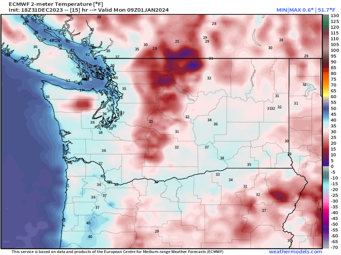
At midnight, expect temperatures in the upper 30s in Seattle, mid to upper 30s in Portland, and low 30s in Spokane. Mountain towns will be in the mid to upper 20s.
2024 will start calm across the region, but a system is ahead on Tuesday. Below is the European model forecast for total rain through Wednesday.

Expect 0.2-0.4” for the lowlands and 0.4-0.6” for the coast. Areas near the Cascades in Eastern WA could get 0.1-0.3”.
This system will bring a round of snow to the Cascades, which is much-needed. Below is the European model snow forecast through Wednesday.

This forecast shows Snoqualmie, Stevens, and White Passes receiving 4-6” of snow, which could bring brief travel impacts (mainly on Tuesday), so drive prepared!
Finally, we’ll look at the extended temperature forecast for Seattle from the European EPS model, seen below.

The reason we are looking at this forecast is the second half of it (January 6-15). Some extended forecasts are hinting at a shift toward colder weather sometime in early to mid January. In this forecast, notice how the range of temperatures (gray and blue vertical lines) show a huge range of possible highs and lows. Toward the end of this forecast, highs range from 15º-50º, with lows ranging from 5º to 45º. Essentially, there is huge uncertainty, but some potential for a colder pattern.
A cold pattern would be great news for the Cascades, where snowpack is far below normal. Below is the Washington snowpack map from the USDA/NRCS.

Notice that the entire state has 25-70% of average snowpack, much below normal. A potential cold pattern would help our struggling snowpack. Stay tuned!

Thanks for the year of blogs. They are informative and well written, and it’s nice to know what’s going on with the weather._
ReplyDeleteHappy New Year Weatherman 2
ReplyDelete