FastCast—Thursday, Dec. 7 to Sunday, Dec. 10:
As the major atmospheric river that brought significant impacts finally moves out of the region, there will only be a brief reprieve before the next atmospheric river (faster & weaker) arrives in the Northwest, likely from Saturday to Sunday. Rivers are currently receding from flooding due to the major atmospheric river, with all rivers likely to fall below flood stage by Thursday evening. On Thursday, expect cloudy skies, highs in the mid 40s, and 0.3-0.8” of rain as another system moves through. Lows on Friday morning will drop to the mid 30s. Friday looks to be the only dry day of the week, with partly cloudy skies and highs in the mid 40s. Lows by Saturday morning will likely drop to the low to mid 30s. Temperatures will rise to the low to mid 40s by the end of the day Saturday, with rain beginning in the morning, continuing through Sunday afternoon. The lowlands will likely receive 1-2” of rain with this next atmospheric river, but that forecast is still being determined. Snow levels will remain around 2,000 feet from Friday to Saturday night, bringing 8-16” of snow to the passes, before snow levels rise above to passes to 4,500 feet on Sunday, bringing rain to the passes and likely melting snow. At this point, it is unlikely that rivers will rise back to flood stage, but that remains to be monitored.
Find atmospheric river rain totals at the bottom of this blog!
—————————————————————
Continue reading the full blog below!
As the major atmospheric river moves out of the region, more rain is on its heels, with a system on Thursday followed by an atmospheric river over the weekend.
Below is the European model forecast showing total rain through Friday morning.
This forecast shows 0.4-1” for the lowlands through Friday, 0.7-1.2” for the coast, and 0.8-1” from Everett northward. Most of Eastern Washington will pick up 0.3-0.5” in this forecast.
Next, let’s take a look at the GFS model forecast, also through Friday morning.
The GFS model agrees with the European, showing 0.5-1” for the lowlands and the coast, with less in Eastern Washington (0.2-0.3”).
The NAM high-resolution forecast, showing rain through Friday morning, is below.
This forecast, zoomed in on Western Washington, shows 0.4-0.8” for the lowlands, and 0.5-1” for the coast. Isolated areas of the lowlands (mainly near the foothills) could get over 1” in this forecast.
Now, let’s transition to mountain snow. Snow levels will be between 2,000 and 3,000 feet on Thursday and Friday, bringing a return of snow to the passes. Below is the European model forecast for snow through Friday morning.
The European model shows 5-10” of snow at the passes through Friday morning, which could bring travel impacts, so be aware of the forecast if you are traveling over the passes. The highest totals will be at Stevens and White Passes due to their elevations.
Finally, we’ll wrap up this portion of the blog by taking a look at the atmospheric river slated to arrive this weekend. Below is the European model forecast showing the atmospheric river.
This forecast, showing precipitable water (a measure of the amount of water in the atmosphere) on Saturday evening, clearly shows the atmospheric river aimed at the region. The lowlands will likely pick up another 1-2” of rain with this atmospheric river, with more likely on the coast. Stay tuned!
———————————————————
12/4-6 Atmospheric River Rainfall Totals:
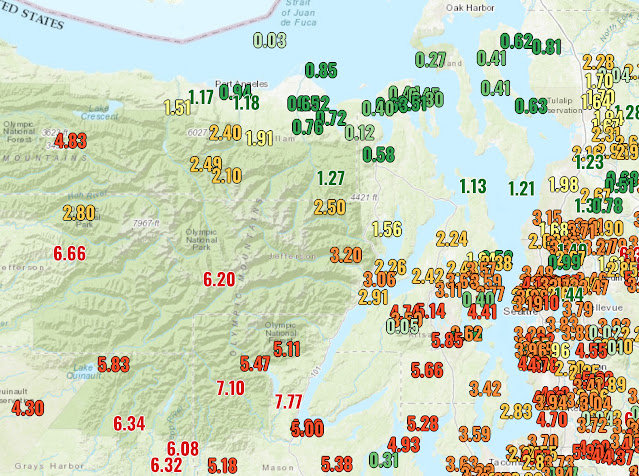
Below are graphics showing rainfall totals across Western Washington due to the recent major atmospheric river. Most of the lowlands received 2.5-4.5” of rain, with the Kitsap Peninsula getting 5-6”, and the mountains getting 6-10”.
Of note is the incredible Olympic rain shadow, with 0.1-0.3” total at Port Townsend and along Whidbey Island, versus 6-8” on the southern slopes of the Olympics, under 50 miles away! Additionally, I marked the Stillaguamish River, where an all-time flood record was set and major impacts occurred in Granite Falls, Arlington, and Silvana. The headwaters of the Stillaguamish received up to 10” of rain.
The final image shows a zoomed-in view of rain totals for areas from Tacoma to Seattle.


No comments:
Post a Comment