FastCast—Monday, Dec. 4 to Wednesday, Dec. 6:
A significant atmospheric river is ahead for the Northwest, with major rain and widespread river flooding expected. Mountain snow levels will rise from 3,500 feet to 10,000 feet, bringing rain to all but the peaks, and melting recent snow. This will bring sharp rises and flooding for most rivers draining the Cascades. Urban flooding is possible as well, so be aware on area roadways. In addition to rain-related hazards, gusty winds and warm temperatures are likely due to the atmospheric river. In the lowlands, expect 2-4” of rain through Wednesday. Temperatures on Monday and Tuesday will rise to the mid to upper 50s in the lowlands, with lows in the low 50s. On Wednesday, highs will drop to the upper 40s, with temps cooling to the low 40s. Winds will gust 30-40 mph in the lowlands as well, from Monday evening to Tuesday morning. Areas north of Everett and near the water could gust higher. Continue reading below for a full update on the atmospheric river.
————————————————————
Rain will begin on Monday morning, continuing through Wednesday, before tapering off. Let’s take a look at the forecast.
Below is the European model forecast showing precipitable water, aka the amount of water in the atmosphere.
This forecast, for late Monday night, clearly shows the atmospheric river aimed directly at the Pacific Northwest. This plume of moisture stretches all the way to Hawaii (bottom left), making it a true “Pineapple Express.”
Zooming in using the UW WRF forecast, take a look at how the atmospheric river will slam into the Pacific Northwest.
Notice how the atmospheric river is oriented from SW to NE, the perfect position to slam into the Olympics, lowlands, and Cascades all at the same time. This shows why the snow levels in the Cascades will rise to 10,000 feet, since the subtropical moisture of the atmospheric river is oriented directly at the mountains.
Now, let’s take a look at the rain forecasts, starting with the European model. The forecast below is for total rain through Wednesday evening.
The European model shows the lowlands receiving 2-2.5” through Wednesday, with 2.5-3.5” in the foothills, 2.5-4” in the Willamette Valley and on the coast, and 3-7” in the Olympics & Cascades. This shows a slight rain shadow NE of the Olympic Peninsula, with that region getting 1.2-1.5”. Additionally, all of Eastern WA will receive rain, with the most (1-1.5”) from the Tri-Cities northeast to Spokane.
Let’s compare this to the GFS (American) model forecast, also through Wednesday evening, seen below.
The GFS forecast shows substantially more rain for the lowlands, with 3.5-4.5” expected. This gives the foothills up to 5.5”, with the coast getting 2.5-4”, the Willamette Valley getting 2.3-3”, and Eastern WA north of I-90 getting 0.5-2”. This forecast gives the Olympics and Cascades 5-8” of rain. The NE Olympic Peninsula rain shadow is more pronounced in this forecast, showing 0.7-1.5” in that region.
Now, let’s zoom in to Western Washington for a look at the high-resolution forecast, from the UW WRF model.
This forecast shows 1.5-2.5” for the lowlands, 2.5-5” for the foothills, and 2.5-5” for the coast, with the Olympics and Cascades getting 5-10”. The NE Olympic rain shadow is most pronounced in this forecast, with only 0.2-0.75” in the rain shadow.
Now, let’s shift gears to flooding. Below is the flooding forecast from the NWS Advanced Hydrologic Prediction Service, showing river flood levels for this storm.
Most rivers draining the Cascades & Olympics will reach bankfull (yellow). The Chehalis, Bogachiel, and Neuwakum Rivers will reach minor flood stage (orange). The Snoqualmie, Snohomish, Skykomish, Skagit, Tolt, Nisqually, Cowlitz, and Skokomish Rivers will all reach moderate flood stage (red), with the Snoqualmie at Carnation and Skagit at Concrete expected to reach major (magenta).
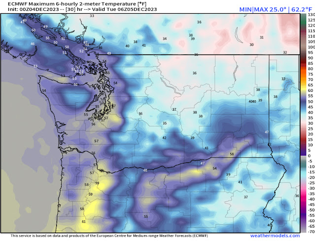
Next, let’s take a look at the increase in temperatures for the region due to the atmospheric river. Below is the European model forecast for highs on Monday.
This forecast shows lowland highs in the mid to upper 50s, with the Willamette Valley reaching the upper 50s to low 60s, and the coast reaching the mid 50s. Eastern Washington will be colder, with highs in the upper 30s to low 40s, except near Walla Walla and the Tri Cities, where highs will reach the 50s.
Finally, let’s take a look at the wind potential for Monday night to Tuesday morning, starting with the European model, seen below.
This forecast shows lowland winds gusting 30-40 mph, strongest near the water, with winds on Whidbey and Camano Islands reaching 40-45 mph, and the coast reaching 40-50 mph, with gusts over 50 mph possible from Westport southward.
The last forecast we will look at is the NAM high-resolution forecast for wind gusts late Monday evening.
This forecast is far stronger than the European and is far less likely, but still possible. The NAM shows lowland winds gusting 40-50 mph, with areas from Everett northward gusting 45-55 mph. The coast would gust 45-55 mph, except up to 60-65 mph on the immediate shoreline. Again, this situation is less likely, but still possible.
I will have another update Monday night as the atmospheric river begins to impact the region. Stay tuned and stay safe!


No comments:
Post a Comment