At 10:55 AM CDT on Sunday, Hurricane Ida made landfall near Port Fourchon, Louisiana, as a 150 mph, 930 mb, Category 4 hurricane.
Ida had many devastating impacts. 2 people have died as of Monday evening, and over 1 million customers remain without power in Louisiana. Wind gusts of 75-170 mph were recorded around Louisiana. Storm surge of 10+ feet and 10+ inches of rain were recorded as well.
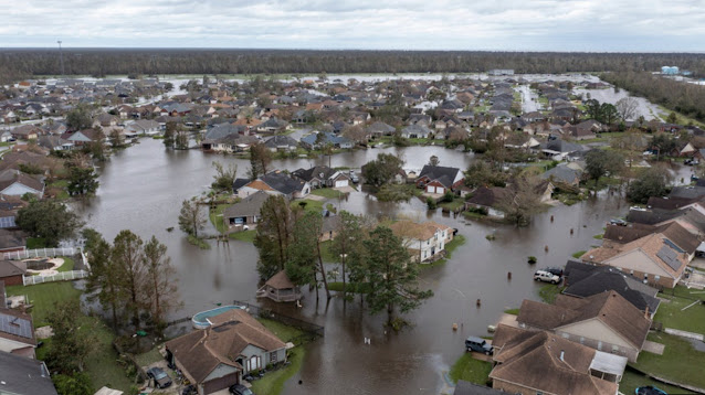
Below is an image from weather.com of the town of Laplace, LA, which was completely flooded due to a levee failure during Ida.
One of Ida’s biggest impacts was knocking out power to the entire city of New Orleans. The weather.com photo below shows a major transmission feeder line that was knocked over as winds gusted 90-100 mph.New Orleans authorities called this a “catastrophic” failure. A major transmission line failure like this can cause thousands to millions of people to lose power (failures such as this have happened, on a lesser scale, in some of the great Pacific Northwest windstorms).
The NWS map below shows peak wind gusts in SE Louisiana, ranging from 90 mph at New Orleans Int’l Airport to 128 mph in the Mississippi Delta.
Unofficial reports suggest gusts of 100-172 mph in coastal areas of SE Louisiana. Any way you look at it, Ida was one of Louisiana’s most devastating hurricanes, and it will be months until the area has fully recovered. Many residents face having no power for days to weeks following the storm.
Ida, now a Tropical Depression, is moving NE through the Mississippi Valley and Mid-Atlantic, and will accelerate offshore over the Northeast by Thursday.
Keep those impacted by Ida in your thoughts and prayers. For more information on Ida’s impacts and frequent updates on the situation, visit weather.com.
Transitioning to the Pacific Northwest…calm weather is expected to start September. Below is the Weather Underground forecast for Federal Way.
Some showers are possible through early Tuesday, then it gets sunnier, with highs in the low 70s on Wednesday, warming to upper 70s-low 80s by the end of the week. Expect morning lows in the mid 40s to low 50s. Showers and slightly cooler weather return by the weekend.


No comments:
Post a Comment