FastCast--Monday, April 15 to Friday, April 19:
Sunday was warm and beautiful across much of Washington state, with lowland highs reaching the mid to upper 60s! However, significant changes are ahead, with a large cooldown on Monday and Tuesday. Breezy westerly winds will gust up to 40-45 mph along the Strait and in Island County through midday Monday, with gusts of 20-30 mph possible around the lowlands through Monday evening. Monday will be mostly cloudy, with lowland highs in the low to mid 50s. Highs on Tuesday will be relatively similar, but clouds will decrease throughout the day. Temperatures rebound on Wednesday, with lowland highs increasing to the upper 50s to low 60s. Of note is that Wednesday morning lows will likely drop to the low to mid 30s across the lowlands, meaning that localized frost is possible. Be aware of this if you have sensitive plants. Highs will increase to the mid to upper 60s on Thursday and Friday. Expect conditions to be mostly sunny from Wednesday to Friday!
-----------------------------------------------------------------------------------
Continue reading the full blog below!
After a beautiful weekend, a cooldown is in store across the state to begin the work week.
Let's start with the forecasted temperature change from Sunday afternoon to Monday afternoon, seen below in the European model forecast.
Almost the entire state will see a 10-20° drop in temperatures on Monday compared to Sunday. The coast will see a lesser drop since marine air had already moved in earlier on Sunday.
This temperature decrease is being driven by gusty westerly winds, that increased late Sunday evening, and will continue at times through Monday. Let's take a look at the NAM high-resolution forecast, showing peak wind gusts through Monday.
This forecast shows westerly winds along the Strait of Juan de Fuca and in Island County gusting 40-45 mph, strongest on Northern Whidbey Island and near Port Angeles. The coast and lowlands will gust 20-30 mph at most. Eastern Washington is a different story, with most areas near the eastern slopes of the Cascades gusting 40-50 mph, strongest in wind-prone gaps such as the Kittitas Valley, and in wide, flat areas downwind of gaps, such as the Waterville Plateau. The Palouse region and areas east of the Columbia River Gorge will also see gusts of 35-40 mph.
These winds will usher in cooler temperatures across the entire region. Below is the NWS NBM high-resolution forecast for highs on Monday.
Expect lowland and coastal highs to drop to the low to mid 50s, warmest from Tacoma to Olympia. The Willamette Valley will drop to the upper 50s. Eastern Washington has one more warm day, with highs remaining in the low to mid 60s, except in the upper 60s in the lower Columbia Basin.
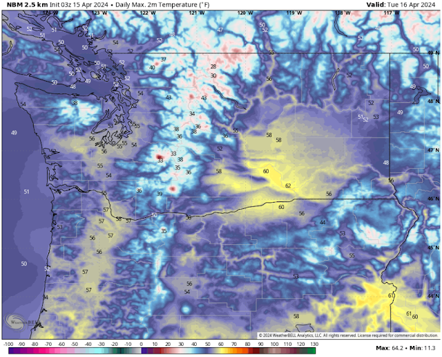
By Tuesday, most of the state will be on the cooler side, as seen below.
The coast and lowlands will again be in the low to mid 50s, with the Willamette Valley in the mid to upper 50s. Eastern Washington will cool dramatically, with highs only in the low 50s near Spokane to the low 60s in the Tri Cities.
Conditions will begin to get warmer by Wednesday, but before we get there, we'll have a chilly morning, with some frost possible. Below is the NWS NBM forecast for Wednesday morning's lows.
On Wednesday morning, lows will drop to the low to mid 30s in Western Washington and the Willamette Valley, and will also drop to the low to mid 30s in Eastern Washington. This means that some frost is possible across the state. This is a threat to sensitive plants, so be aware of this frost possibility on Wednesday morning.
Finally, here's a look at highs on Wednesday, as temperatures begin to rebound across the state.
Highs in the lowlands and along the coast will increase to the upper 50s to low 60s under mostly sunny skies. The Willamette Valley will warm into the mid 60s, with Eastern Washington increasing to the mid 50s around Spokane and the low to mid 60s in the Columbia Basin.
Stay tuned for more information on what looks to be a warm and sunny end to the week!


No comments:
Post a Comment