FastCast—Sunday, Nov. 26 to Thursday, Nov. 30:
A persistent cold and dry pattern will continue for the Pacific Northwest through the end of November. For the lowlands, expect morning fog (sometimes lingering into the afternoon), with afternoon sun. There is a possibility that if an inversion develops (where cooler air is trapped near the surface…aka trapped in the low elevations of both sides of the Cascades), fog and low clouds will remain widespread through the day, with temperatures staying in the upper 30s to low 40s most of the day. Temperature-wise, in the lowlands, expect highs in the low to mid 40s, with cold morning lows in the mid 20s to low 30s, coldest away from the shoreline. Be aware for potential freezing fog, which can bring significant driving hazards around the region. A significant pattern change to much stormier weather is possible to start December, so stay tuned.
With little wind and multiple cold & dry days ahead, air quality will likely degrade. Check air quality at the link below and consider the impact of burning before doing so.
Washington State Air Quality Map—PurpleAir (zoom in to find your location)
——————————————————
Continue reading the full blog below!
A persistent cold, calm, and generally sunny pattern will prevail for much of the next week across Washington state. Let’s take a look at the forecast!
We’ll start with the forecast for low temperatures on Sunday morning, seen below from the European model.
In the lowlands, expect lows in the mid 20s to low 30s, with the coast and Willamette Valley reaching the upper 20s to low 30s. Eastern Washington will drop to the upper teens to mid 20s.
Next, the forecast for lows on Monday morning, seen below.
Monday will be similar, with morning lows in the lowlands reaching the mid 20s to low 30s. The coast will reach the low to mid 30s, and the Willamette Valley will reach the upper 20s to low 30s. Eastern Washington will remain in the upper teens to mid 20s.
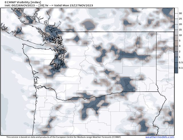
Next, let’s take a look at the fog forecast for Monday morning, seen below from the European model.
Notice that parts of the lowlands have visibility of 0.1-0.5 miles, along with parts of Eastern Washington, including the Tri Cities and Walla Walla. A good amount of this fog could be freezing fog, which can create the same (and sometimes worse) hazards than black ice.
Next, the European model forecast for lows on Tuesday morning, seen below.
On Tuesday morning, expect lowland lows in the mid 20s to low 30s again, with the Willamette Valley dropping to similar levels, and the coast remaining in the low 30s. Eastern Washington will stay cold, with lows still in the low to mid 20s (isolated teens).
Here is the European model fog forecast for Tuesday morning.
Fog is somewhat widespread from around Thurston County all the way to Vancouver BC, with visibility down to 0.1-0.3 miles. Areas of fog are likely in the Willamette Valley and parts of Eastern Washington as well.
Although a pattern change is likely ahead to begin December, it’ll be quite cold before we can get to the stormier weather. Below is the European model forecast for highs on Wednesday.
Expect Wednesday’s highs to only reach the low 40s for the lowlands and mid to upper 30s in Eastern Washington. This will be due to an inversion trapping colder air near the surface. Notice that the mountains are warmer than the lower elevations.
Finally, take a look at the NWS Climate Prediction Center (CPC) precipitation outlook for December 1-5.
This is a good signal for a pattern change to wetter and stormier weather for the Northwest to begin December, with the CPC showing a 50-60% probability of above average precipitation for the Northwest.
Stay warm out there (and be aware for cold-related hazards!).


No comments:
Post a Comment