FastCast—Friday, Nov. 10 to Monday, Nov. 13:
After a relatively calm few days and a weakening storm that moved through on Thursday, a stronger storm will impact the Northwest from Friday afternoon through Saturday. The main impact will be strong winds, with a decent round of rain and mountain snow for the higher passes. Winds will likely gust 40-45 mph for most of the lowlands, 45-50 mph on the coast, and 50-55 mph from Everett northward, especially for Island, Whatcom, and San Juan Counties. Isolated gusts of 55-60 mph are possible for those areas. Region-wide, winds will peak from late Friday night through midmorning Saturday. Most of the lowlands will also receive 0.75-1.3” of rain through Sunday morning, most falling from Friday afternoon through Saturday morning. Higher elevations in the mountains, such as Paradise, Chinook Pass, and the North Cascades Highway will receive 6-12” of snow, with isolated higher amounts. Stevens and White Passes could see 0.5-2” of snow, as snow levels will hover around 4,000-4,500 feet. The next system will bring another round of rain and higher mountain snow from Sunday night to Monday. Through Monday, expect lowland highs in the low 50s, with lows in the mid 40s.
———————————————————————
Continue reading the full blog below!
An active couple days is ahead for Western Washington, as a storm approaches the region, with impacts being felt across the region. Let’s take a look at the forecast!
First, the wind forecast. We’ll start with the European model forecast for peak gusts through Saturday night.

This forecast (which is in knots) shows peak gusts from Everett southward reaching 40-45 mph, strongest early Saturday morning. For areas north of Everett, especially Island, San Juan, and western Whatcom Counties, peak gusts will likely reach 45-55 mph. Isolated gusts of 55-60 mph are possible. The coast will gust 45-50 mph. Both the coast and North Sound will have peak winds from late Friday night to early Saturday morning. Additionally, parts of Eastern Washington, mainly from Moses Lake to Spokane, will gust 40-50 mph on Saturday.
Let’s compare this to the NAM high-resolution wind forecast, first showing gusts at 1 AM Saturday.
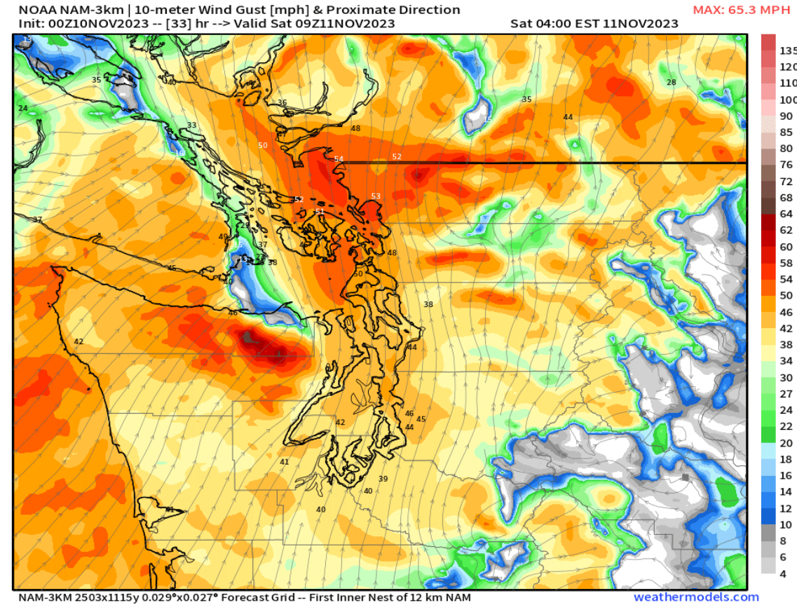
The NAM shows strong gusts of 40-45 mph for most of the region very early Saturday morning. Whidbey Island, San Juan & Whatcom Counties, and the immediate coastline will gust up to 55 mph.
Next is the NAM forecast for 6 AM Saturday.

The NAM forecast shows peak winds for the metro area being around sunrise on Saturday, with gusts of 40-45 mph (isolated gusts closer to 50 mph).
Remember, it is still early in the season, and this weekend’s forecasted winds will likely cause tree damage and some power outages across the region. Trees still have lots of leaves, which will make them more susceptible to damage. Be prepared for winds and monitor the forecast accordingly!
Next, we will take a look at the rain forecast. First, the European model, showing total rain through Sunday morning (most will fall from Friday afternoon through Saturday morning, with some showers through Saturday).
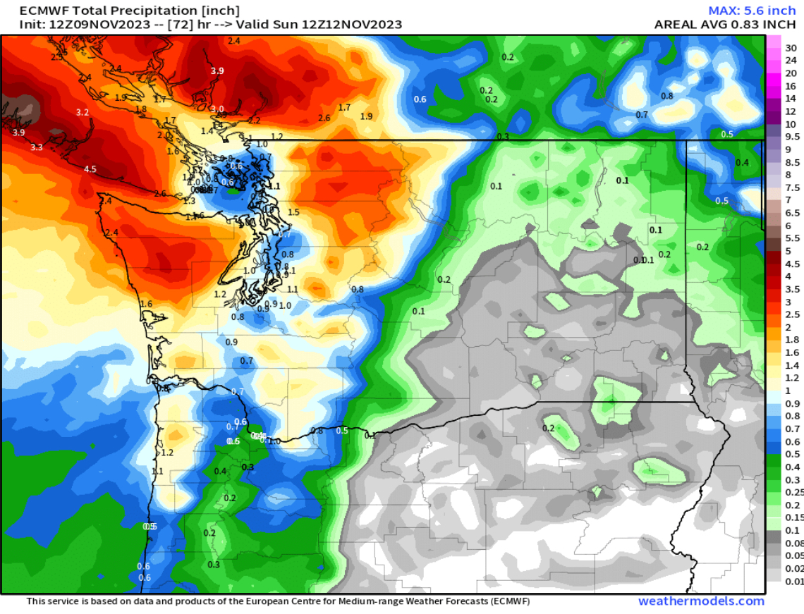
Below is the GFS (American) forecast, showing a similar scenario to the European.

The GFS forecast also shows 0.7-1.2” of rain for the lowlands, with 1-2.7” on the coast (most on the North Coast), and 1-4” in the mountains, most in the Olympics and North Cascades. The GFS and European strongly agree that Eastern Washington will remain almost completely dry with this storm.
Finally, we’ll end tonight’s blog with a look at the snow forecast through Sunday morning from the European model.

This forecast shows significant snow for higher elevations in the North Cascades and the higher peaks, with the North Cascades Highway, Mount Baker, and Paradise likely to get 6-12”. The passes will get much less due to snow levels staying around 4,000-4,500 feet during the storm. Expect 0.5-2” at most at the passes.
Stay tuned for a wind update on Friday night!

Not looking forward to this weekend, think we are on our way to winter. Enjoy the weather information you give us.
ReplyDelete