FastCast—Tuesday, Nov. 21 to Friday, Nov. 24:
The next system is expected to move into the region late Tuesday, with rain lasting through early Wednesday. For the lowlands, expect 0.3-0.6” of rain through early Wednesday morning. Then, conditions will dry out and cool down, with a dry Thanksgiving expected. Temperatures will be a bit interesting. On Tuesday, expect lowland highs to reach the low to mid 50s due to southeasterly flow. Rain will move through from Tuesday evening through early Wednesday. On Wednesday, temperatures will reach the upper 40s, with clouds decreasing by evening. Thanksgiving will bring morning clouds and afternoon sun, with highs in the mid to upper 40s. Friday will likely be mostly sunny, with highs in the mid to upper 40s. Low temperatures will reach the mid 30s on Tuesday morning, the low to mid 40s on Wednesday and Thursday mornings, and down to the low to mid 30s on Friday morning.
———————————————————
Continue reading the full blog below!
The next system is ahead for Western Washington, bringing one final round of rain before Thanksgiving. Let’s take a look at the forecast.
Below is the rain forecast from the European model.
The European model shows 0.3-0.6” for the lowlands, 0.6-0.9” for the coast, and 0-0.1” for Eastern Washington. Most rain will wrap up by early Wednesday morning.
Let’s compare this to the NAM high-resolution forecast, showing rain through Wednesday.
The NAM high-resolution model shows 0.3-0.5” for the lowlands, with 0.5-0.9” on the coast, and scattered areas of a trace of rain for Eastern Washington.
Tuesday will be an anomalously warm day for the lowlands. Below is the European model forecast, zoomed in to Western Washington.
Expect lowland highs to reach the mid 50s, with some areas (mainly near the foothills) reaching the upper 50s, due to downslope flow.
Let’s take a look at the extended forecasts from the European Ensemble (EPS) forecasts, from Seattle and Spokane.
First, the EPS Seattle forecast.
Aside from Tuesday, notice that temperatures will remain on the cooler side, with highs in the mid 40s through the end of November. Lows will cool for Friday to Monday, dropping to the upper 20s to low 30s around the lowlands.
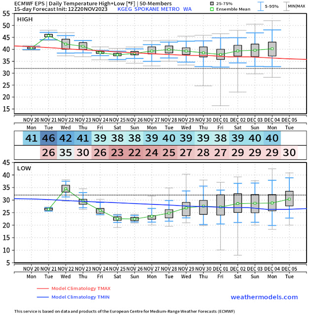
Let’s compare this to Spokane’s forecast from the European EPS model.
In Spokane, temperatures will remain in the upper 30s to low 40s, with overnight lows on the cold side, especially from Thanksgiving to early next week. Some mornings may get as cold as the low 20s!
Enjoy the relatively calm and normal weather ahead!


No comments:
Post a Comment