FastCast—Wednesday, Sep. 20 to Sunday, Sep. 24:
A system is moving through Western Washington as we go from Tuesday night to Wednesday morning. Areas from SeaTac northward in the lowlands will receive 0.3-0.5” of rain, with up to 1” in the Cascades. Areas from SeaTac south and on the coast will get 0.05-0.2” of rain. Highs on Wednesday will reach the low to mid 60s in the lowlands. This system will also bring the first dusting of snow to the highest peaks, with the snow level dropping to around 6,000 feet briefly on Wednesday morning. Conditions will clear almost completely on Thursday, with lowland highs reaching the upper 60s to low 70s, and chilly morning lows in the mid 40s. Friday’s highs will increase more, reaching the mid to upper 70s, with lows in the mid to upper 40s. However, Friday looks to be the last stand for warmer high temperatures. Clouds will move in on Saturday and Sunday, with highs dropping to the upper 60s to low 70s and a chance of showers on Saturday night and then again on Sunday night as a significant weather change (with far more rain) moves in. Stay tuned over the next few days for more information about the upcoming weather change.
————————————————————
Continue reading the full blog below!
A system is moving through as I write this blog, with showers across Western Washington (and soon in Eastern Washington). Let’s take a look at the upcoming forecast!
First, the precipitation forecast from the European Ensemble (EPS) through late Friday.

This forecast shows that most rain will fall from Tacoma northward and east of Puget Sound, with 0.2-0.4” expected. From Everett northward, expect 0.2-0.5” of rain, with up to 0.8” in the Cascades. The coast will get 0.1-0.2”. Eastern Washington will get 0.2-0.4”, except 0.4-0.9” from Spokane south and from the Tri-Cities east.
Let’s compare this to the GFS forecast, also showing precipitation through Friday night.

The GFS shows far less precipitation overall, but also shows most for the Cascades and parts of Eastern Washington.
Going back to the European Ensemble (EPS), let’s zoom in on Western Washington.

Notice that the highest precipitation amounts are from Sea-Tac Airport north toward Everett, and east into the Cascades. Those areas have a chance for Convergence Zone banding, which will bring prolonged precipitation on Wednesday. Up to 0.75” is expected for areas such as Renton, Bellevue, and the Cascade foothills from Black Diamond northward. Areas from Everett northward will also get 0.3-0.8”. Areas not mentioned will likely get a trace to 0.2”.
This system will also bring the snow level down to 6,000 feet on Wednesday morning, and some higher peaks will get their first dusting of snow! Below is the first European Ensemble (EPS) snow map of the season!

Notice some higher peaks could get a trace to 0.5” of snow…a sign that storm season is getting closer. If you’re hiking in the backcountry, be prepared for significantly cooler temperatures than recent days.
Besides rain, you’ll notice significantly cooler temperatures on Wednesday, as seen in the European model forecast below.

On Wednesday, expect lowland highs in the mid 60s, coastal highs in the upper 50s to mid 60s, Willamette Valley highs in the upper 60s to low 70s, Eastern Washington highs in the upper 50s to upper 60s.
Moving on to Thursday, expect temperatures to increase in the lowlands with clear skies. The European model forecast is below.

Expect lowland highs on Thursday in the upper 60s to low 70s, coastal highs in the upper 50s to upper 60s (up to the low 70s inland), Willamette Valley highs in the mid to upper 70s, and Eastern Washington’s highs in the mid 60s to low 70s.
Temperatures will increase further on Friday, before a cooldown for the weekend and beyond. Friday’s highs from the European model are below.
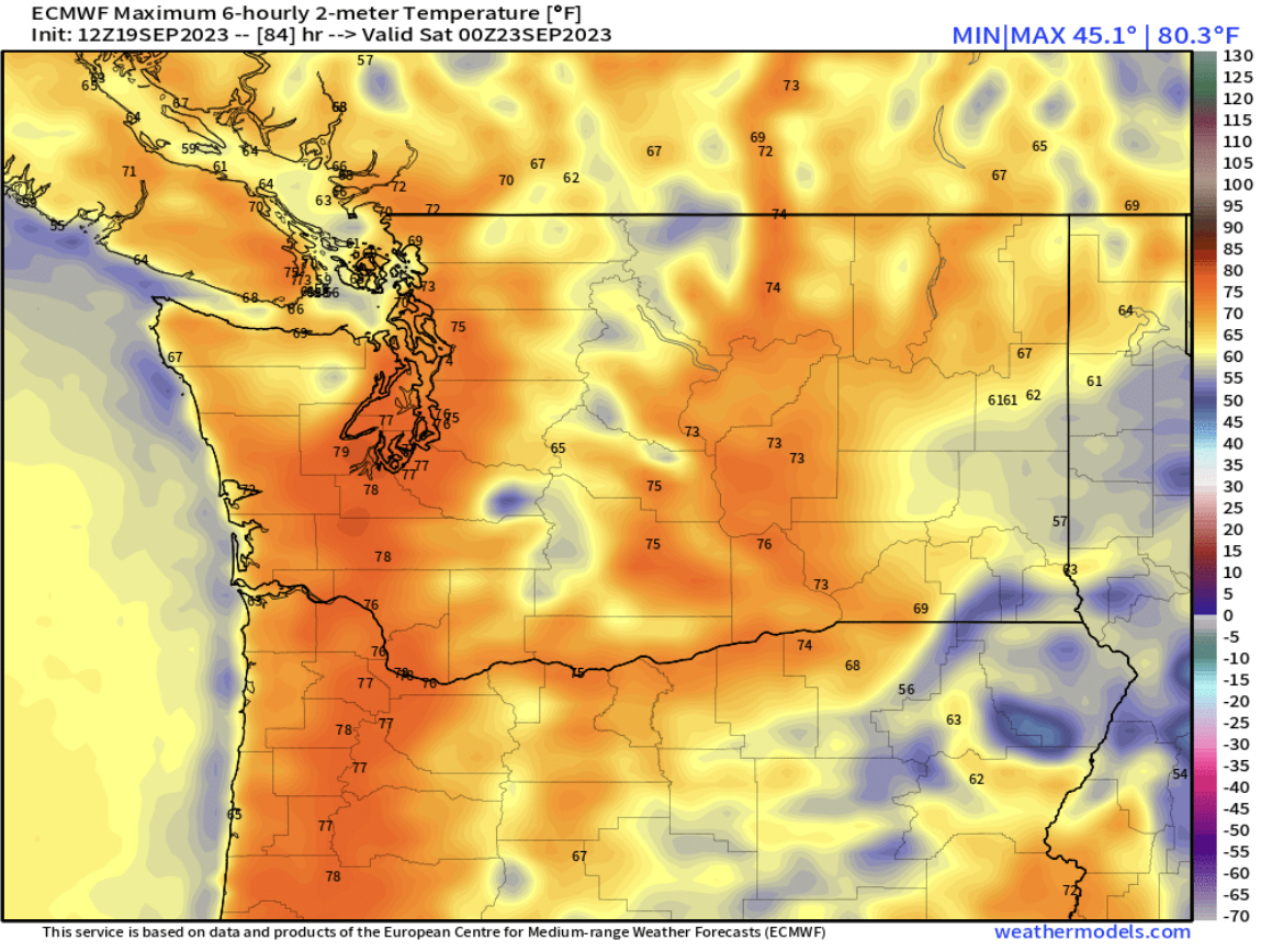
Expect lowland and Willamette Valley highs to reach the mid to upper 70s on Friday. The coast will reach the upper 50s to mid 60s, and Eastern Washington will reach the low 60s to mid 70s, coolest near the Idaho border south of Spokane due to lingering showers.
Finally, what you’ve been waiting to see…the “major changes” mentioned in the blog title! While this forecast below is not certain and will surely change, it represents the likely trend for the rest of September. Below is the EPS forecast showing ensemble mean precipitation through September 30th.

Wow!! This forecast shows 2-3 inches of rain for the lowlands, with even more for the coast and mountains! This is more rain than Western Washington has received in the past 4 months, and would certainly put an end to wildfire season.
Stay tuned as we get closer to a major weather change!

No comments:
Post a Comment