FastCast—Sunday, Sep. 2 to Tuesday, Sep. 5:
A warm Saturday is expected to begin Labor Day Weekend, with partly to mostly sunny conditions and highs in the mid 70s to mid 80s. Clouds and potential showers will move in early Sunday morning, with cloudy conditions, and highs dropping to the upper 60s to low 70s. Similar conditions are expected on Monday, with highs in the mid to upper 60s and some continued showers. Low temperatures will remain in the mid to upper 50s, with some areas in the low 60s overnight. Most of the lowlands will receive no rain to around 0.1” over the weekend. Conditions will remain the same on Tuesday as well.
———————————————————
Continue reading the full blog below!
Labor Day Weekend will start off warm, with conditions getting cooler and showers moving in later in the weekend. Let’s take a look at the forecast!
Below is the European model forecast for highs on Saturday, the warmest in a few days.

Expect lowland highs to reach the upper 70s to mid 80s, warmest between Portland and Tacoma. The coast will reach the mid 70s to low 80s, except in the upper 60s to low 70s at the ocean beaches. Eastern Washington will reach the low 80s to low 90s, hottest around the Tri Cities, and the Willamette Valley will reach the low to mid 80s.
On Sunday, significant cooling will occur in the lowlands as more clouds arrive. Below is the European model forecast.

On Sunday, expect lowland highs to drop to the upper 60s to low 70s, coastal highs to drop to the low to mid 60s, and the Willamette Valley to drop to the low to mid 70s. Eastern Washington will remain in the upper 70s to upper 80s.
By Monday, lowland temperatures will drop further, with Eastern Washington cooling as well. The European model is below.

Lowland highs will drop to the mid to upper 60s, the coast will remain in the upper 50s to mid 60s, and the Willamette Valley will drop to the upper 60s to low 70s. Eastern Washington will drop significantly, down to the mid 70s to mid 80s.
Now for the rain forecast. Showers will move northward into Oregon, with thunderstorms possible, on Saturday, advancing toward Washington on Sunday and through Monday. Let’s take a look at the European Ensemble mean for rain through Monday night.

This forecast shows 0.05-0.2” of rain for most of the lowlands, with lesser amounts in Eastern Washington, and around 0.2-0.3” in the mountains.
We’ll compare this to the GFS forecast below, also showing rain through Monday night.

The GFS shows less rain in Western Washington (0-0.1”), with little to no rain in Eastern Washington. Notice how both forecasts show higher rain totals over the Oregon Cascades, showing the higher chance of thunderstorms and heavier precipitation there.
Looking at the extended outlook from the European EPS forecast, we can observe some potential trends. First, the forecast for Seattle.

Notice the temperature peak on Saturday, followed by a drop this upcoming week, with overnight lows dropping to the low 50s. However, a potential warming trend is possible by mid-September, so stay tuned for more information on that.
We’ll end with the forecast for Spokane, seen below.
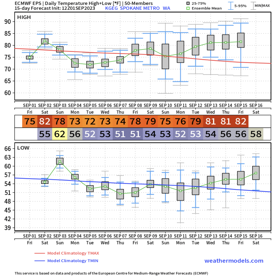
The trend in Spokane is nearly the same as Seattle, except the temperatures are a bit warmer.
Stay tuned for more information on our upcoming weather conditions, and enjoy the holiday weekend!

No comments:
Post a Comment