FastCast—Monday, Sep. 18 to Thursday, Sep. 21:
Conditions have cooled from Saturday, and will continue to cool in the first few days of this week. A weak system will move through from late Sunday night to Monday morning, with a chance of a trace to 0.1” of rain in the lowlands. Highs on Monday will reach the mid to upper 60s, with some clearing expected in the afternoon. Partly cloudy to mostly sunny conditions are expected on Tuesday, with highs in the mid 60s to low 70s. Clouds will increase on Tuesday evening, as another system moves in. This system will bring rain to most of the region, with 0.1-0.3” expected, most possible in a potential Convergence Zone feature between SeaTac and Everett. Isolated higher (or lower) amounts of rain are possible around the lowlands. Highs on Wednesday will be on the cool side, likely in the low to mid 60s across the lowlands. The system will move east by Wednesday afternoon, with clearing skies and a cool morning on Thursday. Sunny conditions are ahead on Thursday, with highs in the low 70s. Expect lows this week in the upper 40s to low 50s, except in the mid 50s on Monday morning and in the mid 40s in some spots on Thursday morning. Check out the bottom of the blog for a note on wildfires in the Olympic Mountains.
———————————————————
Continue reading the full blog below!
A couple weak systems are ahead for Western Washington, one from late Sunday to Monday morning, and another from Tuesday night to Wednesday morning. The second system has a higher potential for rain. Incoming rain will likely be quite helpful for wildfires in the Cascades and Olympics. Let’s take a look at the forecast!
Below is the European EPS (Ensemble) mean forecast for rain through Wednesday afternoon.
The EPS shows a total of 0.1-0.3” in the lowlands, with up to 0.4” in the foothills and in Whatcom & Skagit Counties. The coast will receive a total of 0.1-0.3”, more north of Kalaloch. The Cascades will get 0.3-0.6”, though this might be overdone. Eastern Washington and areas from Olympia southward could get 0.05-0.1”.
Remember, most rain will fall from late Tuesday through Wednesday morning, as far less rain is possible on Monday.
Next, let’s take a look at the GFS forecast, also showing rain through Wednesday afternoon.
The GFS forecast is relatively similar, showing 0.1-0.2” for the lowlands, with up to 0.3-0.4” for Whatcom County and the coast. The Cascades could get up to 0.4-1.2”, but this could be overdone. Eastern Washington could get 0-0.2”, with widely scattered amounts.
Finally, the graphical representation of the EPS forecast, showing 24-hour precipitation. I’ve outlined the Sunday/Monday system in red and the Tuesday/Wednesday system in blue.
Notice how less ensemble members show rain on Monday, but more show rain on late Tuesday/Wednesday morning. Also, notice how many ensemble members show higher rain amounts from early next week through the beginning of October (so stay tuned in the coming days!).
Now, let’s take a look at expected temperatures. First, the European model forecast for highs on Monday.
Expect lowland highs in the mid 60s to low 70s on Monday, coastal highs in the upper 50s to mid 60s, Willamette Valley highs in the mid to upper 70s, and Eastern Washington’s highs in the low 70s to low 80s.
Temperatures will warm slightly in the lowlands on Tuesday, between systems. The European model forecast is below.
Tuesday’s highs will reach the upper 60s to low 70s in the lowlands, upper 50s to low 60s on the coast, low 70s in the Willamette Valley, and the upper 60s to upper 70s in Eastern Washington, one of the coolest days there in awhile.
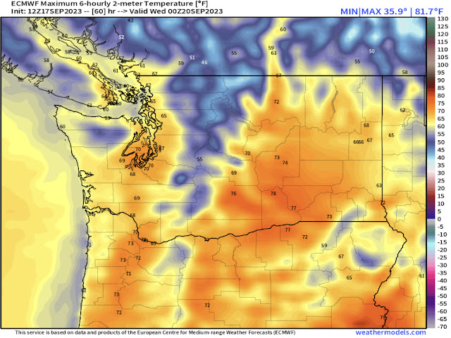
Finally, the highs for Wednesday, seen below.
With a wetter and slightly stronger system moving through, highs will drop to the low to mid 60s in the lowlands, upper 50s to mid 60s on the coast, mid 60s to low 70s in the Willamette Valley, and only the mid 60s in Eastern Washington.
———————————————————
Hotter and drier conditions on Saturday brought explosive growth to wildfires in the Olympic Mountains. Pyrocumulus smoke clouds were visible across the lowlands, with smoke plumes drifting over the North Sound in the evening. Below is a photo I took from the Point Ruston area on Saturday around 5 PM, looking toward the Central Olympic Mountains.
Smoke plumes reached up to 13,000 feet, and multiple fires grew 2-4 times their previous size. We will have to watch the fires in the Olympics for any potential impacts to air quality over the coming days, but incoming rain will hopefully be beneficial.


You are so right about the rain, I woke up to rain this morning. We need it to green the lawns up.
ReplyDelete