Let’s take a look at the latest wind forecasts (as of 9 PM Sunday). The first burst of winds will accompany the frontal passage, between 12 and 3 AM Monday. The high resolution HRRR model forecast below shows predicted wind gusts at 3 AM Monday.
Winds gusting 40-50 mph in the lowlands and 45-60 mph on the coast and in the Northwest Interior will accompany the frontal passage. There will be a slight lull in the winds from early Monday morning through midday, before winds pick up again in the afternoon.
The European model forecast below shows peak gusts on Monday afternoon & evening.
Expect gusts of 40-50 mph in the lowlands and 50-60 mph on the coast and in the Northwest Interior. Eastern Washington will experience gusts of 50-65 mph.
These winds, which will last for 12-24 hours in some locations, will likely bring tree damage and isolated power outages to Western Washington, and those same hazards plus blowing dust in Eastern Washington.
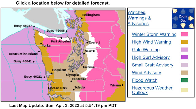
Due to these winds, a Wind Advisory has been issued for the lowlands from 12 AM to 8 PM Monday, and High Wind Warnings are in effect for the WA & OR coasts, the North Sound, and Eastern WA & OR. All these alerts (plus Winter Storm Warnings) create a colorful NWS Seattle map…viewed below.
If you click here, you can view the information in each alert on the NWS Seattle website by clicking the alert’s name.
Another major impact of this storm will be significant mountain snow. Below is the NWS Seattle forecast for snow through Tuesday morning.
Expect lesser amounts of snow at Snoqualmie Pass, and significant amounts of 18-24 inches at Stevens and White Passes, and even more (30-48”) at higher elevations, such as Paradise and Hurricane Ridge. Snow levels will rapidly fall with the frontal passage early Monday morning, dropping to around 2,000 feet. Additionally, winds gusting 30-45 mph at times will bring areas of low visibility and blowing snow to the passes.
This storm will also bring rain (heavy at times) to Western Washington. The high resolution NAM model forecast is below, showing rain expected with this storm.
Expect 0.4 to 1 inch of rain around the lowlands, with more (1.5-3”) on the coast and from Olympia southward (1-2”).
There is also a chance of thunderstorms on Monday, due to an unstable atmosphere behind the cold front. The UW model below shows instability (CAPE index) on Monday afternoon.
CAPE instability values of 100-400 are expected for Western Washington, decent for April. Expect widespread showers on Monday, with the threats of heavy rain, hail, and thunder & lightning in any shower.
One final note…expect 16-25 foot swells on the Pacific Northwest Coast from midday Monday through Tuesday evening. These are large waves, especially for this time of year. Stay safe on the beaches!
Stay tuned to our local meteorologists on Twitter for updates, and stay safe!


No comments:
Post a Comment