FastCast—Saturday, Apr. 30 to Wednesday, May 4:
A rainy beginning to the weekend is expected for Western Washington. Rain is moving in as of Friday night, and will continue through midmorning Saturday. Expect totals of 0.4 to 0.8 inches south of Everett and 0.2 to 0.4 inches north of Everett. There is also a slight chance of thunderstorms Saturday afternoon. Thunderstorms are not likely, but take caution as always when a shower moves in! There will be a mostly dry & cloudy day on Sunday, before rain arrives very early Monday morning. Expect weekend highs in the upper 50s to low 60s (warmest on Sunday). Temperatures drop on Monday as another round of showers moves through. The showers will total 0.2 to 0.4 inches around the area. Highs will drop to the mid 50s on Monday. Conditions dry out on Tuesday, with dry conditions on Wednesday as well. Highs will be in the low 60s on Tuesday and the upper 60s to low 70s on Wednesday! Expect lows over this entire period to be in the mid to upper 40s, with some spots dropping to the low 40s at times.
————————————————————
Continue reading the full blog below!
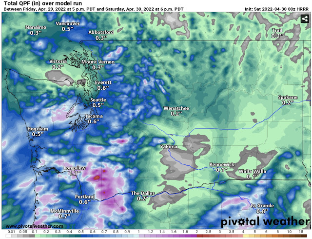
After a couple mostly dry days, another round of rain is ahead for the entire region, with the most rain falling overnight Friday into Saturday, continuing through midmorning Saturday. Isolated showers will continue in some areas through Saturday evening. The high resolution HRRR forecast for rain through 6 PM Saturday is below.
Expect 0.4 to 0.8 inches through Saturday for areas Everett southward, in the foothills, mountains, and on the coast. North of Everett, 0.2 to 0.4 inches are expected, with a rain shadow over the Sequim/Port Angeles areas. The most rain from this system will fall over the Southern WA Cascades and SW Washington, near Longview/Kelso. 0.8 to 2 inches of rain is expected in this area.
Temperatures are getting warmer, with more days as of late having highs in the upper 50s to low 60s. Case in point is the GEFS (ensemble version of the GFS model) forecast for next Wednesday, seen below.
Most forecast models agree that Wednesday will be a nice and spring-like day, with highs in the upper 60s to low 70s! Eastern Washington, Southwest Washington, and the Willamette Valley will likely be in the low to mid 70s!


No comments:
Post a Comment