FastCast—Wednesday, Apr. 13 to Sunday, Apr. 17:
Winter-like weather continues in Western Washington, with chilly temperatures expected, although showers will decrease. Expect light rain/mountain snow at times through Friday. Temperatures will be noticeably chilly for April. Expect highs in the low to mid 50s, and cold lows in the low to mid 30s. Lows will be near or below freezing on Wednesday and Thursday mornings. Conditions will be partly to mostly cloudy. A system will bring rain on Saturday, then temperatures warm to the upper 50s on Sunday. A wetter pattern looks to be in store for next week, with temperatures slightly below normal (better than this week’s substantially below normal temperatures)!
———————————————————
Continue reading the full blog below!
“Abnormal” is the correct word to describe the recent spring weather across most of the Western and Northern United States in recent days.
Starting in the Pacific Northwest, SW Washington and NW Oregon were hit with a historic April snowstorm on Monday, leaving traffic chaos, roads closed, and even some downed trees and power outages. Snow totals varied substantially, with a peak of nearly 10-12 inches in the foothills of Oregon’s Coast Range (West Portland) and in Washington Southern Cascade foothills, including Washougal, seen in the WSDOT camera image below from 7:50 AM Monday.
Vancouver and Ridgefield, WA both received 4-7 inches, and the Portland metropolitan area received 1-3 inches, with even more in Portland’s higher hills.
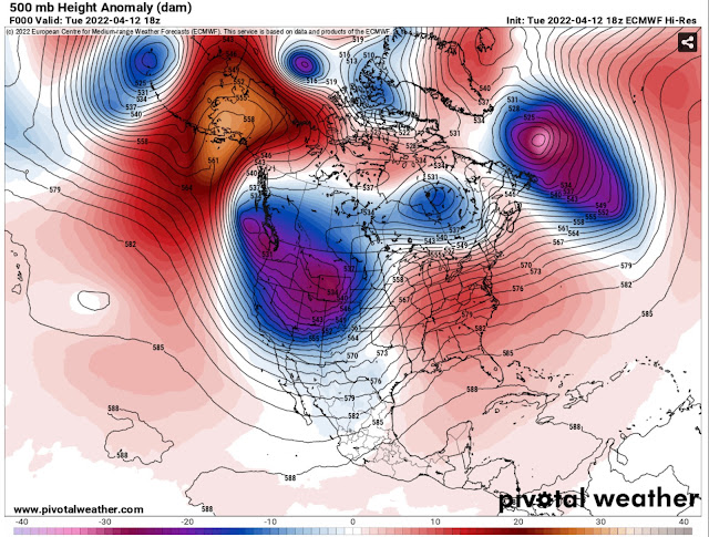
Because of this trough, weather systems approach the Pacific Northwest from a northwesterly direction, instead of from the S-SW as usual. A different approach direction for the weather systems brings colder air from Canada and Alaska, instead of warmer air from across the Pacific Ocean.
These are mind-boggling snow totals considering that it is April. The city of Minot will likely receive over 30 inches of snow!
Winds will gust 45-55 mph in addition to 12-36 inches of snow. This is a full-on blizzard…in spring!


No comments:
Post a Comment