Friday was the hottest day of this short heat wave, with many interior locations reaching the low 90s. The Cascade Foothills reached the mid 90s. Portland reached the mid 90s to near 100, and Eastern Washington was scorching at 100-110 degrees! Puget Sound area highs are below.
Perhaps you noticed the haze moving north into our area on Friday. This is a plume of wildfire smoke from fires in California and Oregon. This smoke is higher in the atmosphere and isn’t currently impacting surface air quality, but skies will be quite hazy. Below is the HRRR Smoke model for 7 PM Friday.
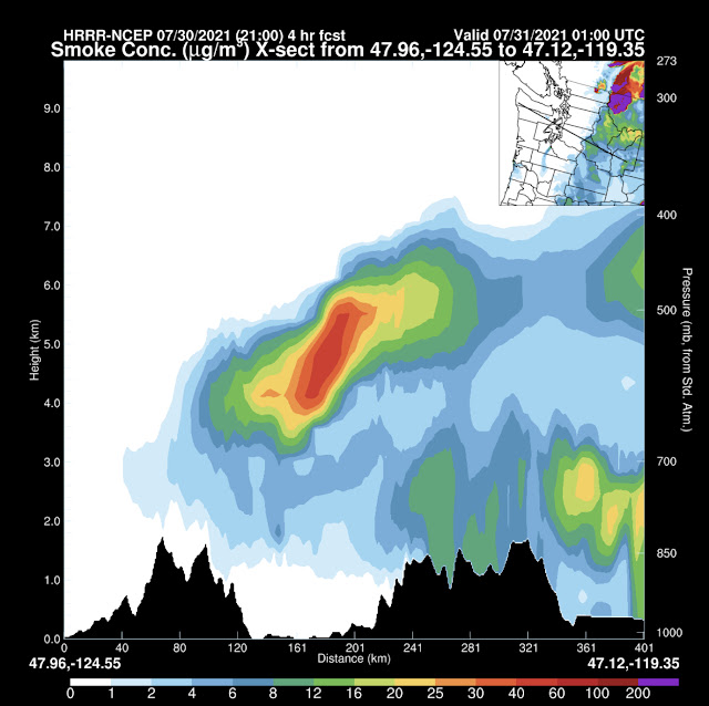
A moderately heavy concentration of smoke aloft is over our area. Below is a cross section of the smoke overhead at the same time. (How to read this: Olympics on left, Cascades on right, Seattle area in middle).
Smoke doesn’t reach the surface except in the mountains.
Heavy smoke aloft is expected to continue through at least Saturday. Below is the forecast for 3 PM Saturday. Some of this smoke may be coming from fires in Eastern Washington and Idaho.
Smoke may not be as visible on Saturday and Sunday due to clouds moving into the area, though hazy skies are to be expected. There's a small chance that some small amounts of smoke may mix down to the surface (air quality to the moderate category).
Once clouds move away, another hot day is expected on Monday. Bottom line: expect highs of 80-85 degrees each day except Monday, which will be hotter (85-90 degrees). Temperatures will be a bit cooler by the water and warmer in the valleys & foothills. Lows will be in the upper 50s to low 60s area-wide.
You saw that correctly! Rain!!! A system moving in late next week will possibly bring measurable rain showers to our area. More details on this are still evolving, so stay tuned for updates! Let's time it out below...
Wow! The entire state of Washington is forecast to get 0.25-1.5 inches of rain (depending on location) by 5 PM next Friday (August 6th)! Most of the Pacific Northwest will get substantial precipitation, a very welcome change for the region.


No comments:
Post a Comment