Sunday, February 27, 2022

Atmospheric River: Heavy Rain, Flooding, and Gusty Winds

 Stand For Freedom, Stand With Ukraine 🇺🇦 

FastCast—Sunday, Feb. 27 to Friday, Mar. 4:

An atmospheric river is moving in to Western Washington. Significant rain totals are expected, with 2-4 inches likely over the lowlands. The heaviest rain will fall from Sunday afternoon to early Tuesday morning. Urban flooding and standing water is expected. River flooding will also occur. Moderate to major flooding is expected on the Snoqualmie River basin and on the Cowlitz, upper Nisqually, Stillaguamish, and Skokomish Rivers. Gusty winds, up to 30-45 mph, are possible around the lowlands through Tuesday. Additionally, the atmospheric river will bring subtropical air. Highs will reach the mid to upper 50s on Monday and Tuesday, with lows in the mid to upper 40s.

—————————————————————

Continue reading the full blog below!

Update 9:20 AM Monday: Urban and Small Stream Flood Warning issued for the Puget Sound area from Everett southward, through 7 AM Tuesday. Alert below.


——————————————————————

After a relatively dry February, the month will end with a deluge. An atmospheric river will bring heavy rain and significant totals are expected by Tuesday. 

Below is the HRRR forecast for rain totals from Sunday morning to Tuesday morning.


Expect up to 4 inches in the lowlands. A significant rain shadow can be observed over Whidbey Island and the NE Olympic Peninsula. The coast and Coast Range will be hammered, with 4-10 inches of rain. 

This is all due to a potent atmospheric river aimed right at Western Washington. Below is the UW forecast showing the atmospheric river at 7 AM Monday.


This atmospheric river will impact the area from late Sunday to early Tuesday, peaking midday Monday.

Flooding is expected, both on rivers and in urban areas. The UW forecast below shows expected precipitation over the Puget Sound area from 4 AM Monday to 4 AM Tuesday. 


Dark purple, red, and orange colors indicate between 1.5 and 3 inches of rain in 24 hours (see the key on the right side of the graphic). This amount of rain, generally south of Seattle, will likely cause urban flooding. Be aware of ponding, small stream flooding, and flooding in low-lying areas. 

Also, notice the sharp cut-off in rain totals from North Seattle to the rain shadow. Port Townsend will get 0.1-0.2” in the same period that Tacoma will get 1.75-2”!

Widespread river flooding is expected as well. Below is the flooding forecast from the Advanced Hydrologic Prediction Service.


The most significant flooding will occur in the Snoqualmie/Snohomish/Tolt River system, where moderate to major flooding is expected. Snoqualmie Falls will be a spectacle on Tuesday! The Stillaguamish, upper Nisqually, and Cowlitz Rivers will also experience moderate to major flooding. In Eastern Washington, expect bankfull stage to minor flooding on the entirety of the Naches and Yakima Rivers.

Additionally, expect wind gusts of 25-40 mph in the lowlands at times between Sunday and Monday evening, and up to 50 mph on the coast. Avalanche danger will also be elevated due to high snow levels and heavy rain in the mountains.

Update 7 PM Sunday: Avalanche Warnings have been issued for the Cascades of Washington by the Northwest Avalanche Center (NWAC)

Stay tuned for updates on the flooding on Twitter and from our local forecasters!

Friday, February 25, 2022

Significantly Wetter Pattern & Atmospheric River to End February

FastCast—Saturday, Feb. 26 to Tuesday, Mar. 1:

After a cold & mostly dry week and an abnormally dry February, a significant pattern change is ahead. One more cold night, with lows in the mid to upper 20s, is expected overnight Friday into Saturday. Then, the ridge will collapse, with rain and wind moving in by Saturday evening. A front late Saturday into Sunday will bring rain and gusty winds (30-35 mph in the lowlands, 45-50 mph on the coast and in the North Sound). On Monday, as an atmospheric river will set up over the region. By Tuesday, expect 2-3 total inches of rain across Western Washington. Most rain will fall from late Sunday through early Tuesday. The passes will receive snow through Sunday, then snow levels will rise above 4,000 feet, bringing mountain rain from Sunday evening onward. Rivers will rise, and some will approach bankfull. The Skokomish River on the SE Olympic Peninsula and potentially the Snoqualmie River will briefly reach flood stage around Tuesday. Temperatures will also warm significantly in the lowlands, with highs by Tuesday in the mid to upper 50s, and lows in the mid to upper 40s.

———————————————————————

Continue reading the full blog below!

After a dry February and a cold week, a significant pattern change is ahead, with heavy rain, higher snow levels, and gusty winds.

Below is the European model forecast for rain through Tuesday.


Significant rain is expected, with 2-3.5 inches likely across Western Washington, and even more on the coast. Less will fall in the north interior (1.5-2”).

Most of this rain (1-2”) will fall from late Sunday through early Tuesday, as an atmospheric river sets up over the region. The UW model below shows the atmospheric river aimed at Western Washington at 6 AM Monday.


This atmospheric river will bring heavy rain at times from late Sunday to early Tuesday, along with snow levels over 4,000 feet.

The atmospheric river will also bring warm temperatures on Monday and Tuesday. The European model below shows high temperatures on Tuesday, in the wake of the atmospheric river.


Temperatures in the mid to upper 50s (low 60s in the Columbia basin) will be quite a change from our recent Arctic blast.

Periods of gusty winds are possible as well. Expect gusts up to 35 mph in the lowlands at times through Monday evening. The strongest gusts will be on the coast and in the North Sound, where gusts reaching 40-50 mph are expected at times from late Saturday to Monday afternoon.

February will end much wetter than the rest of the month. The 1st to 25th have had around 0.75” of rain. The 26th to 28th will likely have 2-3 inches…more in 3 days than the previous 25!

Stay tuned for more information about the upcoming active weather!

Wednesday, February 23, 2022

Arctic Airmass: Very Cold Temperatures & Another Slight Chance of Snow

FastCast—Thursday, Feb. 24 to Saturday, Feb. 26:

An Arctic airmass has been impacting Washington state for the past day. Temperatures dropped into the upper teens to low 20s across Western Washington overnight Wednesday. A weak system will move through on Thursday morning, bringing a slight chance of light snow to most of Western Washington. At most, 0.25-0.5” of snow is possible. Mostly sunny conditions will prevail by midday Thursday through Friday evening. Expect highs in the 40s and lows in the mid to upper 20s. By Saturday, temperatures will moderate. Highs will reach the low 50s and lows will be in the mid to upper 30s. An extended period of rain is expected to begin on Saturday.

————————————————————

Continue reading the full blog below!

With an Arctic airmass over the Pacific Northwest, the 2nd coldest night of the year (besides New Year’s) was Tuesday night to Wednesday morning. Below are low temperatures on Wednesday morning.


Lows reached the upper teens to low 20s in Western Washington, even into the mid to upper 20s on the coast. In Eastern Washington and the Cascades, lows reached -10 to the low teens.

From late Wednesday to Thursday morning, a weak system will move through Western Washington. This system will bring a chance of light snow to parts of the region. The HRRR snow forecast is below.


Light snow is possible across most of the lowlands, with impacts not expected, and no locally higher amounts like what happened on Monday. 

Following this weak system, another cold night is expected. Friday morning’s low temperatures are shown below from the European model.


This will be the last very cold night during this cold snap in Western Washington. Lows will reach the mid to upper 20s in Western Washington and low single digits to low 20s in Eastern Washington and the Cascades.

A wetter and warmer pattern will begin on Saturday. The GFS rain forecast through the end of February (next Monday) is below.


We will likely make up for some of the precipitation deficit that has been the result of a very dry February. Stay tuned as a more active pattern begins this weekend!

Monday, February 21, 2022

Arctic Air Arrives: Snow Showers, Cold Temperatures, and Frigid Wind Chills

FastCast—Tuesday, Feb. 22 to Friday, Feb. 25:

In the wake of our weather systems this weekend, Arctic air has begun to move into Western Washington. Fraser outflow winds are gusting 40-60 mph in Whatcom County, bringing low humidity and frigid wind chills. Parts of Western Washington have received snow showers today, with the most significant accumulations near Stanwood and Camano Island (up to 8 inches). Other areas, particularly from North Bend to Federal Way, the Northern Olympic Peninsula, and areas between Everett and SeaTac have received snow too. These showers may continue through 1 AM Tuesday for areas west of the Sound. Dry air moves in as the showers end. Skies will clear by midday Tuesday, and temperatures will drop into the upper teens to mid 20s across Western Washington by Wednesday morning. Wind chills will make it feel like 5-20 degrees at times due to Fraser (N-NE) and Cascadia (easterly gap) winds, gusting 20-35 mph in the lowlands and up to 65 mph in Whatcom County. Expect highs in the mid 30s to near 40 and lows in the mid to upper 20s through Friday.

———————————————————

Continue reading the full blog below!

As the Arctic boundary moved south into the lowlands, it produced some snow showers around the region. Snow accumulated up to 8 inches near Stanwood and Camano Island on Monday morning. North Bend got some significant accumulation (see WSDOT camera image below) and areas from Covington to Federal Way, between Everett and SeaTac, and the Northern Olympic Peninsula also received snow accumulations on non-road surfaces on Monday evening.


Snow accumulated enough to cover I-90! Some areas west of Puget Sound may receive snow showers through around 1 AM.

Meanwhile, in Whatcom and San Juan Counties, the Fraser outflow winds are roaring. Gusts have reached 60 mph in Bellingham and 50-55 mph on the San Juan Islands. The entire power grid for San Juan County has been knocked out, and wind chills are in the 10-15 degree range. (Peak gusts as of 10 PM Monday below)


These winds will continue gusting 40-60 mph through Tuesday afternoon. Wind chills of 5-15 degrees are expected in these areas.

In the Central Sound, E-NE gap winds are expected, gusting 20-35 mph, through early Wednesday. Gap wind conduits are clearly seen on the 8 PM Tuesday forecast from the NAM model.


Winds out of the Fraser River Valley, the Stampede Gap (between Seattle and Olympia), and the Columbia River Gorge (Portland) can be seen gusting up to 35 mph by Tuesday evening.

Below are wind chills at the same time (8 PM Tuesday).


With winds gusting 20-35 mph, wind chills of 10-20 degrees are expected in the lowlands. Winds gusting 40-50 mph are possible in East Central Washington, and Eastern Washington wind chills will reach a frigid -10 to 15 degrees.

Additionally, the air will be quite dry due to the prolonged offshore flow. Dewpoints on Wednesday morning are below. (Dewpoints are the temperatures where water droplets form).


Wow! Dewpoints in Western Washington will reach 0 to 5 degrees! Other forecasts agree, generally showing dewpoints of 0 to 10 degrees and relative humidity of 20-40%. You’ll notice how dry it is…expect your throat to be dry and your skin to be chapped. 

Temperatures will be quite cold for the second time this winter. Below is the NAM forecast for low temperatures on Wednesday morning.


Wednesday will be the coldest morning, with lows in the upper teens to low 20s in Western Washington and 5 to 15 degrees in Eastern Washington. 

Expect lows in the mid to upper 20s (colder in some spots) through Friday night in the lowlands. Highs will only reach the mid 30s to low 40s in the lowlands. Lows in the 5-15 degree range are expected in Eastern Washington through Friday night. 
 
Stay tuned for more information as the Arctic air and cold temperatures set in!

Saturday, February 19, 2022

Rain & Mountain Snow, Then Very Cold Weather Arrives

FastCast—Sunday, Feb. 20 to Thursday, Feb. 24:

A weather system moving through the region from the northwest will bring rain (rain shadow over the lowlands) and mountain snow. Convergence Zone bands will bring localized heavy rain and heavy mountain snow, especially around Snoqualmie and Stevens Passes. Expect an additional 5-15 inches of snow through Sunday at the passes. Heavy snowfall rates are possible in Convergence Zone bands. Breezy conditions are possible outside the Convergence Zone, with winds up to 35 mph. Shower activity will continue through Monday, with a chance of rain/snow mix or brief snow accumulations possible. Then, winds will shift to the N-NE and temperatures will drop. Expect lows in the 20s to low 30s from Tuesday to Friday mornings. The coldest mornings will likely be Wednesday and Thursday. Lows will reach the upper teens to low 20s. Wind chills will reach the low to mid teens at times next week. In Eastern WA and the Cascades, expect lows of -5 to 15 degrees, and wind chills of -20 to 15 degrees.

——————————————————

Continue reading the full blog below!

The winds of change are blowing across Western Washington. A weather system is moving through from the northwest, shadowing the lowlands, but bringing snow to the mountains, likely totaling 1-2 feet by late Sunday. 

Below is the HRRR model forecast for snow through late Sunday.


Expect 1-2 feet of snow (more possible at higher elevations) through Sunday. Convergence Zone bands will bring locally heavier snowfall rates and briefly lower visibility. 

The northwest orientation of this system isn’t visible from the snow maps, but it is easy to see on the HRRR forecast for rainfall through Monday.


Light amounts of rain (0.1-0.3 inches) are expected in the lowlands, with more (0.4-1”) under the Convergence Zone, between north Seattle and Mount Vernon. 

Showers (potentially rain/snow mix or brief snow showers) will continue through Monday. Impacts or significant snow accumulations aren’t expected. Then, much colder air will move into Western Washington, as Arctic air moves south. 

Cold temperatures and wind chills are expected, coldest on Wednesday morning. Below is the European model forecast for Wednesday morning lows.


Expect very cold lows in the upper teens to low 20s on Wednesday morning, with lows in the 20s on Tuesday, Thursday, and possibly Friday mornings as well. The Cascades and Eastern Washington will have lows of -5 to 15 degrees.

Brisk northerly winds (especially in East-Central Washington) will bring very cold wind chills as well. Below are forecasted wind chills from the European model at 4 AM Wednesday, the coldest time.


Bitterly cold wind chills are expected at times next week, coldest on Tuesday and Wednesday. In Western Washington, expect wind chills of 5 to 20 degrees. In the Cascades and Eastern Washington, chills will reach -20 to 10 degrees. The Willamette Valley will also be very cold, at 5-10 degrees.

Stay tuned for more information about the very cold temperatures coming up!

Thursday, February 17, 2022

Is One More Shot at Winter Ahead for Western Washington?

FastCast-Friday, Feb. 18 to Thursday, Feb. 24:

A quiet day is expected on Friday, with rain and mountain snow over the weekend. With systems generally coming from the northwest, the Puget Sound area will be somewhat rain-shadowed. Expect 0.3-0.5 inches, with more in the foothills (0.4-0.75") and the most on the coast and north of Everett (0.6-1 inch). Snoqualmie and Stevens Passes will receive 12-18 inches of snow through late Sunday, with less at White Pass. Higher elevations will receive 18+ inches. Expect travel impacts if you are traversing the passes this weekend, particularly from midday Saturday to Sunday evening. Breezy conditions, with winds up to 35 mph, are possible in the lowlands this weekend. As these systems move out late Sunday into Monday, there is a slight chance of lowland snow showers. Any would be brief and not yield any significant impacts. In the wake of these systems, Arctic air will move into the Pacific Northwest. Drier and much colder weather is expected. Morning lows from Tuesday to Thursday mornings will be in the 20s, and highs will only reach the upper 30s to low 40s. The coldest morning will likely be Wednesday, with lows in the low 20s (mid 20s near the water). In the mountains and Eastern Washington, lows will plummet to 5-15 degrees.

--------------------------------------------------------

Continue reading the full blog below!

Nearly 2 months removed from a major cold outbreak and snowstorm, it appears that one more shot at winter weather is ahead for Western Washington, though it will be much shorter and snow will likely not be an issue. For the second time this winter, the main impact will be cold temperatures (but not as cold as December).

Below is the European model forecast for low temperatures on Wednesday morning, showing what is possible in the coming days.


This is likely on the colder side of what's possible, but the European model has tended to be more accurate this winter.

Why are we reverting back to Arctic air after beautiful (and warm) weather under a week ago? It all comes back to the persistent high pressure ridge offshore in a La Niña pattern. 

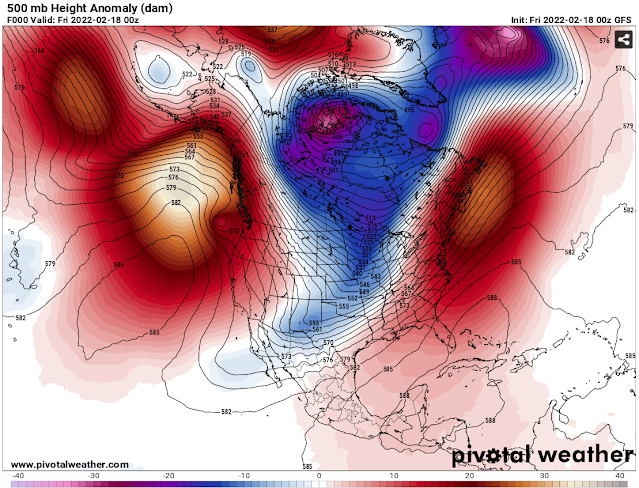
Take a look at the GFS model below showing upper-air patterns on Thursday evening.


A ridge is clearly visible off the Pacific Northwest (white/red), in just the right place to cut us off from Arctic air.

Now look at Tuesday. The ridge has moved further out to sea, and major troughing (blue/purple) is in place over the Western US, opening the door to systems from the northwest and Arctic air from Canada.


This troughing will not only bring cold temperatures next week, but it will also bring rain and mountain snow this weekend. 

Below is the European model forecast for total rain through early Monday morning.


Notice that areas from Seattle westward are rain-shadowed. Expect 0.3-0.6 inches in the lowlands (most in the foothills), and 0.6-1 inch on the coast and north of Everett.

The biggest weekend impact will be mountain snow. Below is a graphic from NWS Seattle showing expected snow accumulation from midday Saturday to Sunday afternoon.


Expect 12-18 inches at Snoqualmie and Stevens Passes, and more at higher elevations. Keep in mind that most of this will fall within 36 hours, so the snow may be heavy at times. Delays are possible over the passes as they receive their biggest snowfall since January.

Stay tuned in the coming days as more details about the upcoming cold temperatures come into focus!

Tuesday, February 15, 2022

Weekend Pattern Change: Rain, Mountain Snow, and Colder Temperatures

FastCast—Wednesday, Feb. 16 to Wednesday, Feb. 23:

After a few weeks of relatively calm weather, a pattern change is ahead on the weekend. But first, a mostly cloudy reminder of the week is expected, with highs in the upper 40s and lows in the upper 30s to low 40s. Then, a pattern change will take place. The persistent high pressure ridge just off the coast will set up further out to sea, opening the door to weather systems and colder air. Showers on Saturday and Sunday will bring 0.3-0.75 inches of rain to the lowlands, with more on the coast and in the North Sound. The passes will receive snow showers through Monday evening. Expect 8-18 inches of snow at the passes. After the system moves out, colder air will move in. Northerly winds will bring cold temperatures and cold mornings next week. Tuesday and Wednesday mornings in particular will likely have lows in the mid to upper 20s. Details are still evolving, so stay tuned!

—————————————————

Continue reading the full blog below!

This weekend, the pattern will change from a dominant high pressure ridge just offshore to troughing over the Pacific Northwest. This will allow a weather system and then colder air to move into the area. 

Below is the GFS forecast showing the trough (instead of our constant ridge) over the Pacific Northwest.


This troughing (purple colors over the PNW) will bring a weather system with rain and mountain snow on Saturday and Sunday (with mountain snow showers lingering into Monday).

It’s too early to accurately pinpoint rain and mountain snow totals, but it is safe to expect 0.2-0.75 inches of rain in the lowlands (0.5-1” coast and N. Sound) and 8-18” of snow at the passes through Tuesday.

What is becoming more certain is that there will be colder temperatures on Tuesday and Wednesday mornings of next week. No snow, as there will be mostly clear skies, and potentially biting northerly winds and cold wind chills at times.

The GFS forecast for next Wednesday morning shows cold air around the entire Pacific Northwest.


Zooming in on Washington, and the European model shows quite a cold morning on Wednesday, Feb. 23rd.


While it is too early to know any forecast for certain, be prepared that temperatures could reach as low as the upper teens to low 20s west of the Cascades, and in the teens to the east.

To show that the European model isn’t the lone prediction of cold temperatures, below is the GFS forecast for roughly the same time.


The GFS is a few degrees warmer, but still shows widespread mid to upper 20s west of the Cascades and teens to low 20s to the east.

It is too early to tell many details of the upcoming pattern change, but stay tuned as more details get refined in the coming days!

Saturday, February 12, 2022

Will This Super Bowl Be the Warmest Ever?

FastCast—Sunday, Feb. 13 to Saturday, Feb. 19:

After a beautiful day on Saturday, another warm day is ahead on Sunday. Temperatures near freezing are possible on Sunday morning. Then, temperatures will reach the upper 50s as clouds move in on Super Bowl Sunday. Showers and cooler temperatures are expected on Monday. Expect up to 0.2” of rain and winds up to 30 mph. Cloudy and calm weather due to persistent ridging will prevail through the week, with a slight chance of showers on Thursday. Expect highs in the upper 40s and lows in the upper 30s to low 40s.

————————————————————

Continue reading the full blog below!

With a persistent high pressure ridge in place across the West Coast, a very hot Super Bowl is expected. The record high for the Super Bowl is 84° (also in Los Angeles) in 1973. That record may be broken this year. 

Below is the HRRR forecast for kickoff (3 PM PST).


Temperatures at kickoff will be in the mid-80s. Temperatures will slowly decrease through the game, but the record may be set around kickoff. Why is this happening? 

A massive high pressure ridge (shown below on the UW model) is centered just off California.


Los Angeles, being on the east side of the ridge, is in the prime position to capitalize on sinking air and warming temperatures.

In Western Washington, warmer temperatures are expected on Sunday as well. Temperatures at 3 PM are below (from the HRRR model).


Temperatures in the mid to upper 50s are expected in the lowlands and Eastern Washington. The Willamette Valley and southern Washington may reach the low 60s.

Enjoy the Super Bowl and the sunny weather!

Thursday, February 10, 2022

High Pressure Ridging Brings Warm Temperatures to the West Coast

FastCast—Friday, Feb. 11 to Monday, Feb. 14:

High pressure ridging across the West Coast will bring warmer temperatures and calm conditions through Sunday. In Western Washington, there will be patchy fog, dense in places, for the next couple mornings. Expect afternoon clearing on Friday and a mostly sunny day (with morning fog) on Saturday. Increasing clouds are expected on Sunday, with a chance of rain on Monday. Expect highs in the low to mid 50s from Friday to Sunday, dropping to the upper 40s on Monday. Lows will be in the low 30s to low 40s, coldest on Saturday and Sunday mornings.

——————————————————————

Continue reading the full blog below!

Major high pressure ridging (seen below on Friday morning from the UW model) is impacting the entire West Coast.


This massive ridge is centered over or just off the Pacific coast. The eastern side of a ridge is where the warmest conditions are, and that’s where most of WA, OR, and CA are.

This ridge may produce the hottest Super Bowl ever. Below are forecast highs on Sunday for Southern California from the European model.


If the temperature in Los Angeles tops 84°, Super Bowl LVI will become the hottest in history.

The heat will extend around the Southwest from Friday until temperatures cool back to seasonal normals by early next week. Below is the European model forecast for high temperatures on Saturday.


Temperatures in in the low 70s to upper 80s extend from Northern California to Arizona.

In Western Washington, the warmest day will be Sunday, as seen in the European model below.


Temperatures in the Lowlands and the Willamette Valley will likely reach the mid to upper 50s, with a potential for some isolated readings in the low 60s. 

In Eastern Washington, the warmest day will be Friday, with highs in the Columbia Basin reaching the low 60s.

Enjoy the calm & sunnier weather!

Monday, February 7, 2022

Midwinter Western US Reservoir Update

FastCast—Tuesday, Feb. 7 to Sunday, Feb. 13:

After a weak system brought some light rain and breezy conditions to Western Washington on Monday, a large high pressure ridge will develop and bring dry weather through at least Saturday. A slight chance of rain is possible on Sunday. Expect clouds in the mornings and some clearing from midmorning into the afternoons. Highs will be in the upper 40s to mid 50s, with lows in the mid 30s to low 40s. For those residents who are sensitive to high barometric pressure, expect high pressure (30.50”+) through early Thursday.

—————————————————————

Continue reading the full blog below!

As dry weather impacts most of the Western United States due to the La Niña pattern, it seems like a good time to look at reservoir levels across the West, with summer approaching.

Starting in Washington, the crucial Yakima River reservoir system is in very good shape, far above last year (green) and average (red). The reservoirs themselves are 50-80% full.


Add to this that most of the snowpack is still held in the mountains, and we are in good shape for the summer. 

The SNOTEL snowpack map for the Western United States is below, as of February 7th.


Most of the West is in decent shape, with 70-130% of normal, which is lower than we’d like to see for this time of winter. No area is over 150% of normal, except the Oregon coast range.The areas with the least snowpack are parts of Oregon and Nevada, eastern Wyoming, New Mexico, and parts of Arizona.

However, good snowpack does not ensure good reservoir situations, and the spring/summer snowmelt won't fill some of the incredibly depleted reservoirs in the Southwest. (All lake levels from US Lakes.info)

Below is the level for critical Lake Mead, on the border of Nevada and Arizona.


At a level of around 1,067 feet, Lake Mead remains near its lowest level ever recorded, where it has been since late July. If conditions don't significantly improve (i.e. 100+ feet added to the lake) more water cuts are possible during the upcoming summer.

In a similar situation is Lake Powell, created by Glen Canyon Dam and straddling the Arizona-Utah border. 


This summer and in the months since, Lake Powell's level has been around 3,530 feet, over 100 feet below "full", and consistently at a record low.

Lake Oroville, in Northern California, stopped generating hydroelectric power from August 2021 to early January 2022. Thankfully, some atmospheric rivers earlier this winter have helped water rapidly refill the lake...sort of.


It has "recovered" to 746 feet, which is 100 feet above its record low. However, it is still over 150 feet below full level, which it did briefly reach in 2017 (red line). 

So...what is ahead? The 3-month precipitation outlook from the NWS Climate Prediction Center is below.


The Pacific Northwest is in very good shape for summer water supply, with above normal levels now, a near-normal snowpack, and above average precipitation expected.

The situation is much more grim in the Southwest and California. Below average precipitation is expected over many areas that have reservoirs very far below normal. Even a near-normal snowpack won't replenish the reservoirs enough for summer.

Another summer of very low Southwest reservoirs seems likely.

Friday, February 4, 2022

Extended Period of Dry Weather Through Next Week

FastCast—Saturday, Feb. 5 to Saturday, Feb. 12:

Due to persistent high pressure ridging offshore (frequent with the La Niña pattern), an extended period of dry weather is expected, through at least mid-February. Besides a slight chance of showers late Sunday into Monday, it will remain dry in the lowlands through the week and into next weekend. Generally, expect highs in the mid 40s to mid 50s, and lows in the mid 30s, except near freezing on Sunday morning. Keep reading below for information on the extended forecast and climate outlooks.

————————————————————

As is common in La Niña patterns, significant and persistent high pressure ridging will dominate the Pacific Northwest over the next week and beyond.

Below is the GFS model showing a large ridge offshore (on Wednesday, Feb. 9th).


This pattern, with a persistent ridge offshore of the Pacific Northwest, is common in La Niña winters. If the ridge sets up nearer to Alaska or further out to sea, a colder and snowier pattern is possible (not likely in the foreseeable future).

The UW forecast below shows the ridge on Tuesday at the surface. 


The ridge is centered just offshore, deflecting weather systems away from Western Washington.

Looking into the future, significantly drier weather is expected. Below is the NWS Climate Prediction Center outlook for February 12th-18th.


This outlook shows a 40-50% chance of below average precipitation in the Pacific Northwest. Of particular concern is the expected lack of precipitation in California. Already quite dry and in need of rain, this will not be good for California’s reservoir levels and vegetation conditions.

Tuesday, February 1, 2022

Chance of Showers Through the End of the Week, Cold Morning on Wednesday

FastCast—Wednesday, Feb. 2 to Saturday, Feb. 5:

Generally calm weather will continue over the next few days. Showers are expected at times through Friday. Some of these showers may have rain/snow mix, mainly on Wednesday. Wednesday morning lows will be in the upper 20s to low 30s across the region. Highs will only reach the low 40s. The highest chance of actual accumulating snow (very brief, if any) will be from Snohomish County northward. Through Friday, 0.1-0.3 inches of rain are expected in the lowlands. On the coast and from Everett northward, 0.4-1.1 inches are expected. The mountains will receive snow as well, with the passes getting 6-18 inches by Friday. Expect lowland highs in the mid to upper 40s and lows in the mid to upper 30s. By Saturday, high pressure will build in the region. Highs will increase to the upper 40s to low 50s, with lows decreasing to the low to mid 30s.

————————————————————

Continue reading the full blog below!

A cold night is expected overnight Tuesday into Wednesday. Lows in the upper 20s to low 30s are expected…and it will be quite cold in Eastern Washington, with lows in the low teens to low 20s. The European model forecast for low temperatures is below.


Some showers are possible on Wednesday morning, with a potential of brief rain/snow mix or very brief accumulating snow from Snohomish County northward. This isn’t very likely though, as seen in the HRRR forecast for snow through Wednesday afternoon.


Between Wednesday and Friday, more rain will fall, with snow in the mountains. Below is the European model forecast for rain through Friday evening.


Expect 0.1-0.3 inches in the lowlands, which will be shadowed from these few weak systems. On the coast and north of Everett, expect 0.4-1.1 inches of rain.

Mountain snow is expected as well. Below is the European model forecast for snow through Friday evening.


Expect 6-18 inches of snow at the passes, with difficult mountain pass travel possible.

Drier weather with highs in the upper 40s to low 50s and lows in the low to mid 30s is expected by Saturday.

Next Storm System Hits Western Washington

  8-26 Video Briefing: Next Storm System Hits Western Washington