FastCast-Friday, Feb. 18 to Thursday, Feb. 24:
A quiet day is expected on Friday, with rain and mountain snow over the weekend. With systems generally coming from the northwest, the Puget Sound area will be somewhat rain-shadowed. Expect 0.3-0.5 inches, with more in the foothills (0.4-0.75") and the most on the coast and north of Everett (0.6-1 inch). Snoqualmie and Stevens Passes will receive 12-18 inches of snow through late Sunday, with less at White Pass. Higher elevations will receive 18+ inches. Expect travel impacts if you are traversing the passes this weekend, particularly from midday Saturday to Sunday evening. Breezy conditions, with winds up to 35 mph, are possible in the lowlands this weekend. As these systems move out late Sunday into Monday, there is a slight chance of lowland snow showers. Any would be brief and not yield any significant impacts. In the wake of these systems, Arctic air will move into the Pacific Northwest. Drier and much colder weather is expected. Morning lows from Tuesday to Thursday mornings will be in the 20s, and highs will only reach the upper 30s to low 40s. The coldest morning will likely be Wednesday, with lows in the low 20s (mid 20s near the water). In the mountains and Eastern Washington, lows will plummet to 5-15 degrees.
--------------------------------------------------------
Continue reading the full blog below!
Nearly 2 months removed from a major cold outbreak and snowstorm, it appears that one more shot at winter weather is ahead for Western Washington, though it will be much shorter and snow will likely not be an issue. For the second time this winter, the main impact will be cold temperatures (but not as cold as December).
Below is the European model forecast for low temperatures on Wednesday morning, showing what is possible in the coming days.

This is likely on the colder side of what's possible, but the European model has tended to be more accurate this winter.
Why are we reverting back to Arctic air after beautiful (and warm) weather under a week ago? It all comes back to the persistent high pressure ridge offshore in a La Niña pattern.
Take a look at the GFS model below showing upper-air patterns on Thursday evening.
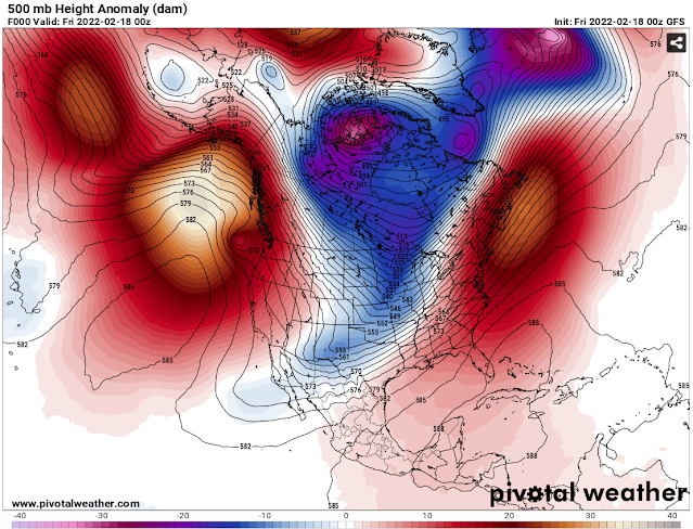
A ridge is clearly visible off the Pacific Northwest (white/red), in just the right place to cut us off from Arctic air.
Now look at Tuesday. The ridge has moved further out to sea, and major troughing (blue/purple) is in place over the Western US, opening the door to systems from the northwest and Arctic air from Canada.

This troughing will not only bring cold temperatures next week, but it will also bring rain and mountain snow this weekend.
Below is the European model forecast for total rain through early Monday morning.

Notice that areas from Seattle westward are rain-shadowed. Expect 0.3-0.6 inches in the lowlands (most in the foothills), and 0.6-1 inch on the coast and north of Everett.
The biggest weekend impact will be mountain snow. Below is a graphic from NWS Seattle showing expected snow accumulation from midday Saturday to Sunday afternoon.

Expect 12-18 inches at Snoqualmie and Stevens Passes, and more at higher elevations. Keep in mind that most of this will fall within 36 hours, so the snow may be heavy at times. Delays are possible over the passes as they receive their biggest snowfall since January.
Stay tuned in the coming days as more details about the upcoming cold temperatures come into focus!

No comments:
Post a Comment