Thursday, March 31, 2022

Active Weather Returns Late Sunday

 FastCast—Friday, Apr. 1 to Thursday, Apr. 7:

On Sunday, active weather will return to Western Washington. On Friday and Saturday, expect partly to mostly cloudy conditions, with highs in the mid 50s and lows in the low 40s. Late on Sunday, rain will move back in to Western Washington. Expect rain to continue through Monday afternoon, totaling 0.75 to 1.25 inches of rain in the lowlands, with 2-3 inches on the coast. Additionally, with a Convergence Zone band over the North Sound (Seattle to Arlington areas), a windy day is expected on Monday to the south and north of that Convergence Zone. As of Thursday, forecasts show winds gusting up to 40-45 mph in the lowlands from late Sunday night to Monday evening. The Sunday-Monday system will bring colder than normal temperatures, with highs in the upper 40s to mid 50s and lows near 40. Also…expect 6-12 inches of snow at the passes. Then, as that system moves out, expect partly cloudy and drier conditions, with highs in the low 50s on Tuesday to the mid 60s on Thursday. Lows will be in the mid 30s on Wednesday morning and then will be in the low 40s. Stay tuned for more information about the active weather ahead!

—————————————————————

Continue reading the full blog below!

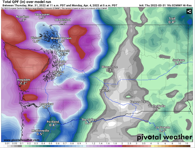
Active weather will return to the Pacific Northwest on Sunday. Rain will move in on Sunday afternoon. Expect 0.75 to 1.25 inches of rain around the lowlands, and 2-3 inches on the coast. See the European model forecast below for rain through 5 AM Monday (more is definitely possible later on Monday).


By midday Monday, rain will be confined to the Convergence Zone, between Seattle and Arlington. 

Mountain snow will accompany the rain, with snow levels around 2,000 to 3,500 feet. The European model forecast for snow accumulations through 5 AM Monday is below.


Expect 6-12 inches of snow at the passes, with more possible in Convergence Zone bands. Higher elevations (5,000+ feet) will receive 12-30 inches of snow, substantial for April!

Another aspect of the upcoming active weather will be windy conditions from late Sunday night through Monday evening. Below is the European model forecast for peak wind gusts through 5 AM Monday (highest gusts will be after this).


Through 5 AM Monday, expect gusts of 35-45 mph around the lowlands. Higher gusts, up to 40-50 mph, are possible through the day Monday.
Stay tuned for more updates on the upcoming active weather!

Monday, March 28, 2022

Spring Temperature & Precipitation Trends and a Calm End to March

 FastCast—Tuesday, Mar. 29 to Sunday, Apr. 3:

A calm & uneventful end to March and beginning of April is expected in Western Washington. Expect a slight chance of showers on Tuesday, with highs in the upper 50s to low 60s, and lows in the mid 40s. Wednesday will be slightly cooler, with highs in the mid 50s. Additionally, expect light rain at times on Wednesday, totaling 0.05 to 0.2 inches in the metro area. Areas north of Everett, on the coast, and in the mountains will receive 0.2 to 0.6 inches, with the most in areas between Everett and Mount Vernon, under the Convergence Zone (on Wednesday and Thursday). A few inches of snow are possible at the passes as well. Expect mostly cloudy conditions through the remainder of the week, with a slight chance of rain from Friday to Sunday. Expect highs in the mid 50s and lows in the upper 30s to low 40s through Sunday.

—————————————————————

Continue reading the full blog below!

March has been a mostly calm month around the Pacific Northwest, with near normal rainfall, temperatures, and overall a typical transition toward spring. With little activity in the near future, let’s take a look at the extended climate forecasts for April to June, from the NWS Climate Prediction Center (CPC)

Below are expected temperature trends from April to June.


This pattern is very reminiscent of La Niña, with below average temperatures expected this spring in the Northwest, and significantly above average temperatures over the southern tier of the US.

Regarding precipitation, below is the CPC graphic for April to June rain trends.


These forecasts show that we are slowly transitioning toward a more neutral phase (though still leaning toward La Niña). Expect average precipitation in Washington, with below average precipitation for much of the other parts of the Northwest, extending into the Plains and Texas.

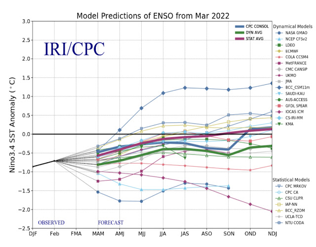
Looking even more broadly, below are the ENSO (El Niño/La Niña) ensemble forecasts for the next year, from the CPC.


Generally, a trend toward more neutral conditions (horizontal black line in the middle of the graph) by the end of summer. This means generally more average conditions for the Pacific Northwest. However, these forecasts have a difficult time during spring, so stay tuned as these get refined.

Back in the short term…below is the expected rainfall through Friday from the European model.


Expect light rain in the metro area, with only 0.05 to 0.2 inches. The most rain will fall in the Convergence Zone (approximately Everett to Mount Vernon) and in the mountains, with 0.3 to 0.75 inches of rain (most in the mountains).

I’m sure many of you noticed how nice and warm it was on Sunday. Below are Sunday’s high temperatures.


It was warmer than the forecast of the low 60s. Most areas reached the mid 60s, with some areas, particularly in the southern and eastern parts of the lowlands, reaching the upper 60s (and even the low 70s)! We won’t have temperatures this warm for the foreseeable future, but high temperatures will consistently remain in the 50s.

Enjoy the calm spring weather ahead!

Friday, March 25, 2022

Calm Weather Ahead & Warming Temperatures

 FastCast—Saturday, Mar. 26 to Thursday, Mar. 31:

Calm weather is ahead, as heavier rain heads toward British Columbia. Expect light rain (if any), totaling 0.05 to 0.15” of rain over the weekend. Areas on the coast and from Mount Vernon northward will receive up to 0.25”. While it will be mostly cloudy, temperatures will be warmer. This weekend, expect highs in the upper 50s to low 60s and lows in the mid to upper 40s. Another round of light rain (0.1 to 0.2 inches) is expected at times from Monday to Wednesday. From Monday to Thursday, expect partly to mostly cloudy conditions with highs in the mid 50s to low 60s, and lows in the  low to mid 40s.

————————————————————

Continue reading the full blog below!

A calm weekend and next week is ahead. Little rain will fall, as the majority of rain will move north to British Columbia. 

The NAM forecast below shows rain through 5 AM Monday. 


Generally, expect light rain around the region over the weekend.

It will definitely feel like spring, with warmer temperatures over the weekend. Below are expected highs on Sunday from the NAM model.


Highs in Western Washington will reach the upper 50s to low 60s, and the Willamette Valley and Eastern Washington will reach the upper 60s to low 70s!

Enjoy a calm and relatively uneventful spring weekend!

Tuesday, March 22, 2022

Warmest Day of 2022 So Far & Calm Weather Ahead

FastCast—Wednesday, Mar. 23 to Sunday, Mar. 27:

Tuesday started foggy with patchy drizzle and ended mostly sunny with the warmest temperatures of 2022. Highs around Puget Sound reached the mid to upper 60s! It was on the muggy side, with dewpoints in the mid 50s. Expect some light rain on Wednesday and winds gusting up to 20-25 mph due to a weak cold front moving through. Temperatures will be in the low 50s. Expect mostly cloudy and dry days on Thursday and Friday, with highs in the upper 50s to low 60s, and lows in the upper 30s to mid 40s. There’s a slight chance of showers on Saturday and a higher chance of showers on Sunday. Highs on the weekend will be in the upper 50s to low 60s.

—————————————————————

Continue reading the full blog below!

Tuesday was the warmest day of 2022 so far! After starting rather gloomy, skies cleared and temperatures warmed into the 60s! 


Highs reached the mid to upper 60s! The mountains even reached the upper 40s to low 50s!

Temperatures will cool down in the days ahead. Additionally, some light rain is expected on Wednesday. Below is the NAM forecast for rain through 9 PM Wednesday.


Generally, expect 0.1 to 0.3 inches of rain around the lowlands. Most rain will fall from Everett northward and on the coast.

Temperatures will also be warmer than previously, with many days reaching the upper 50s to low 60s through next Monday. We are approaching the time of year when average temperatures enter the upper 50s. See the NWS Seattle chart below.


By the end of March, average highs are around 56-58°, and by mid April, average highs top 60°, and don’t fall below 60° until mid October. The red box signifies the upcoming month. 

Very good blog post about how weather impacts the war in Ukraine:

https://cliffmass.blogspot.com/2022/03/the-tactical-and-strategic-implications.html


Introducing The_Weatherman2 YouTube Channel! Click the YouTube logo on the right side of the blog to view the channel (and please subscribe)!

Sunday, March 20, 2022

Significant Texas Wildfires Due to Extraordinarily Dry Conditions

 FastCast—Monday, Mar. 21 to Friday, Mar. 25:

A rainy day is expected on Monday around Western Washington. Expect up to 0.4-0.75 inches of rain in the lowlands (most east of Puget Sound), 0.7-0.9” north of Everett and in the foothills, and 1-1.5 inches on the coast. A mix of rain and snow is possible at the passes, with precipitation changing to all rain by Monday morning. By Tuesday, temperatures will warm significantly (from the mid to upper 40s on Monday). Expect Tuesday’s highs to be in the low to mid 60s, with morning clouds and afternoon sun. A chance of showers and temperatures in the low 50s return on Wednesday, then expect mostly cloudy days on Thursday and Friday, with highs in the upper 50s (potentially the low 60s in some spots). 

————————————————————

Continue reading the full blog below!

In the past few days, significant wildfires have been burning in central Texas. These wildfires have been fueled by very dry conditions and have destroyed over 80 structures. (Photo below from the InciWeb Incident Management SystemMatthew Whelan/Texas A&M Forest Service)


Where are these wildfires? Most of them are in North Central Texas, within the red box in the InciWeb map below.


The largest fire (Eastland Complex Fire) is located in the cluster of fires between Abilene and Fort Worth. At over 54,000 acres, the Eastland Complex Fire has become one of the largest in Texas history. Note: Orange diamonds represent prescribed burns, or intentional fires, set for ecological reasons.

Take a look at the GOES-East weather satellite screenshot from Sunday evening, showing the smoke plumes in Central Texas.


These are significant smoke plumes considering it is March. The NWS Storm Prediction Center outlook from Sunday shows the large swath of “critical” fire weather in parts of the Southwest and Great Plains.


Sunday was incredibly dry, with gusty winds aiding fire growth. Minimum humidity values dropped to 5-15%, levels usually seen in Phoenix. These are seen below in the map of central Texas.


So what’s next around these fires? Weather conducive to fire suppression will move in…but with a twist. That twist is that the much higher humidity and likely rain will be preceded by gusty winds, and most importantly, followed by even stronger and drier winds after the rain moves out. 

Enough rain combined with higher humidity will hopefully provide some fire suppression, although the threat of severe thunderstorms doesn’t help the situation. Below is expected rain for Central Texas from the HRRR model (through 4 AM Tuesday).


The fires are between Abilene and Weatherford, where 0.2 to 0.75” of rain will fall, largely depending on if thunderstorms move over the fires. More or much less may fall depending on individual storm tracks.

This rain will bring some relief, but it’s what happens after the rain that is a cause for concern. Drier air with gusty winds will move in from the Great Plains on Tuesday. Humidity will plummet, and drying NE winds will increase. Maximum wind gusts on Tuesday afternoon are shown below, from the European model.


This next round of winds will gust 35-45 mph, not helping the fires. Let’s hope that the rain, thunderstorms, and higher humidity can suppress them enough. More dry days (with humidity not rising above 60% and gusty winds of 20-35 mph) through the end of this week.

Friday, March 18, 2022

Rain at Times Through Monday, Then Warmer Weather Expected

FastCast—Saturday, Mar. 19 to Wednesday, Mar. 23:

After a few drier days, showers are expected at times through Monday. Through the weekend, expect 0.4-0.8 inches of rain around the lowlands. From Monday to early Tuesday, a bit more rain is possible. Additionally, expect 4-12 inches of snow at the passes this weekend. By Tuesday, the skies will clear up, and temperatures will increase. On Tuesday and Wednesday, expect highs in the low to mid 60s…just in time for spring! Between Saturday and Monday, expect highs in the upper 40s and lows in the upper 30s to mid 40s. On Tuesday and Wednesday, expect highs reaching the low to mid 60s, with lows in the low to mid 40s.

—————————————————————

Continue reading the full blog below!

Over the weekend and into next week, rain will return to Western Washington. Below is the rain forecast through 5 AM Monday from the NAM model.


Expect 0.3 to 0.8 inches of rain across the lowlands. The coast will receive 1-3 inches, and the foothills may receive up to 1.5 inches. A rain shadow is likely on the N/NE side of the Olympic Peninsula as well. More rain is possible on Monday.

With generally colder temperatures in this weekend’s weather systems, mountain snow is expected. Below is the NAM forecast for snow through 5 AM Monday.


Generally, expect around 6-12 inches of snow at the passes, with more at higher elevations. Significant travel impacts aren’t expected.

Once the rain moves out by early Tuesday, warmer weather is expected for Western Washington! Tuesday and Wednesday will have similar high temperatures, likely the warmest of the year so far! Below is the European model ensemble mean forecast (the average of many runs of the forecast model) for high temperatures on Wednesday (the 23rd).


On Tuesday and Wednesday, highs will reach the low to mid 60s in the lowlands. SW Washington, the Willamette Valley, and the Columbia Basin will potentially reach the upper 60s. 

It will definitely feel like spring…and astronomical spring starts on Sunday!

Tuesday, March 15, 2022

Permanent Daylight Saving Time? What the Sunshine Protection Act Means for the Pacific Northwest

On Tuesday, the US Senate voted unanimously to pass the Sunshine Protection Act, legislation that would keep the United States on Daylight Saving Time, also known as Daylight Time, what we are on from mid-March to early November. The Senate’s action on Tuesday sends the legislation to the House of Representatives, where if it passes, it will arrive on the desk of President Biden. If it clears all these hurdles, it will be implemented in November 2023, meaning there will be no "fall-back" on November 5, 2023.

The sun sets over the Pacific Ocean at 4:40 PM on December 31, 2021, viewed from Oysterville, WA. Under the Sunshine Protection Act, this sunset would occur at 5:40 PM.

Now that this legislation has unanimously passed the Senate (a rare feat these days), it has a decent possibility of passing the House and being signed by the President. So…what does the potential implementation of the Sunshine Protection Act mean for the Pacific Northwest?

A summary would be later sunrises and later sunsets from early November to mid-March, as we remain on Pacific Daylight Time. Essentially, the time that is currently “Pacific Standard Time” will be when you notice the biggest changes. The Pacific and Mountain Time Zones would be most impacted with late sunrises. For reference, Pacific is orange and Mountain is green. (Map found here)


A bit of background...under the Uniform Time Act of 1966, states can opt out of the current Daylight Saving Time structure (like Arizona and Hawaii) but states cannot switch to permanent Daylight Saving Time without Congressional approval. The passage of the Sunshine Protection Act would be that approval for all 50 states. 

Let’s go in-depth on the impacts of this legislation in the Pacific Northwest. Below is a graphic from my personal weather station showing solar radiation on each day of December 2021.


December has the least solar radiation of any month of the year, only peaking around 400 watts/meter^2 (In comparison, June and July peak at 1,200-1,500 w/m^2). 

There is a red box around December 13th, 2021, the darkest day of the month. The solar radiation graph for the 13th is below.


Solar radiation only peaked at 68.8 w/m^2. This would be considered quite a "dark" day by normal standards, but it will seem even darker under the Sunshine Protection Act.

Under 2021 time rules, the sun rose at 7:49 AM and set at 4:17 PM, one of the shortest days of the year (at 8 hr, 28 min). 

Under the proposed Sunshine Protection Act, the sun would rise at 8:49 AM and set at 5:17 PM. This means that a normally dark day would seem much darker, with the sun not rising until around 9 AM. A sunrise around 9 AM combined with a very dark day wouldn’t bode well for many people in the Northwest, especially the population impacted by Seasonal Affective Disorder (SAD).

Under the Sunshine Protection Act, sunrises after 8:30 AM would occur from approximately November 26th to February 4th. The benefit of this would be winter sunsets one hour later, eliminating sunsets before 5:15 PM. 

Also...time from March to November (most of spring & summer, part of fall) would be unchanged, meaning that about 9 months out of the year will experience no changes.

The graphic below from a 2019 Cliff Mass Weather Blog post shows solar radiation in Seattle in 2019.


The parts of the year that will be most impacted by the Sunshine Protection Act happen to have the least amount of sun (November through mid-March). Due to the Pacific Northwest’s position at a northern latitude, sunlight is a topic of significant discussion. Opposition to switching to permanent Daylight Saving Time is stronger here than in most of the country. An informative article from The Seattle Times is linked below.


The Sunshine Protection Act is an interesting possibility that will mainly have impacts during late fall and winter. Stay tuned for more information, should the legislation advance.

Saturday, March 12, 2022

Weak Atmospheric River Fueling a Rainy Week

FastCast—Sunday, Mar. 13 to Tuesday, Mar. 15:

After a warm day on Saturday (highs in the upper 50s), a rainy few days are in store for most of Washington state. A storm will approach the Oregon Coast on Sunday, bringing gusty winds there (50-60 mph) and some showers to Western Washington. On Monday, a weak atmospheric river will impact the region, bringing 0.5-1.5 inches of rain, mainly south of Seattle. Areas from Seattle northward will have 0.1-0.75 inches of rain, generally in the rain shadow. The mountains, foothills, and coast will receive 1.5 to 5 inches of rain. Snow levels will hover between 3,000 and 4,500 feet, likely bringing a mix of rain, wintry mix, and wet snow to Stevens and White Passes, and rain at Snoqualmie Pass. Expect up to 6-12 inches of snow at the higher passes. Temperatures will be steady, with highs in the upper 40s to low 50s, and lows in the 40s.

——————————————————————

Daylight Saving Time begins at 2 AM PDT on Sunday, March 13th. Don’t forget to “spring forward!”

——————————————————————

Continue reading the full blog below!

It’s going to be a wet week in Western Washington. We are in the path of multiple storm systems (not any significant ones) that will bring some rain each day for the next few days. Below is the European model forecast for rain through Wednesday morning.


Through Wednesday, expect 0.75 to 1.75 inches of rain around the lowlands. The coast, foothills, and mountains will receive 2-4 inches, potentially more. Eastern Washington will also receive 0.4-1 inch, much-needed rainfall for the region.

Most of this rain will fall on Monday (0.75-1.25” in the lowlands) due to a weak atmospheric river that will bring more moisture to Western Washington. The UW forecast below for Monday evening, showing moisture in the atmosphere.


The Oregon Coast and Willamette Valley will receive the brunt of the impacts from this atmospheric river, with 2-4 inches of rain on the coast and 1.5-2.5 inland.

The Oregon Coast will also be the epicenter of a small windstorm on Sunday. A compact and weakening low center will make landfall around 7 AM Sunday on the Northern Oregon Coast, as seen below in the UW forecast.


The area outlined in red will receive the strongest winds, due to a higher pressure gradient (close black lines). Expect winds gusting up to 60 mph through Sunday afternoon, particularly from Tillamook to Coos Bay. On the Southern Oregon Coast, expect waves of up to 20-30 feet!

Thursday, March 10, 2022

Much Wetter Pattern Ahead

FastCast—Friday, Mar. 11 to Wednesday, Mar. 16:

After a relatively dry week, a much wetter pattern is ahead for Western Washington. A cloudy day is expected on Friday, then the rain arrives on Saturday evening. By Monday evening, expect 1-2 inches of rain around the lowlands. Showers will continue on Tuesday and Wednesday, bringing another 0.3-0.5”. Breezy conditions are possible on Sunday, with gusts of 25-40 mph possible. Check out the blog below for information about a windstorm on the Oregon Coast. Temperatures will be a bit below average, with highs in the upper 40s to mid 50s, and lows in the upper 30s to mid 40s.

——————————————————————

Continue reading the full blog below!

After a relatively dry last week, a much wetter pattern is on the way, starting on Saturday. Below is the expected rain total by 11 PM Tuesday from the European model.


Expect totals of 1-2.5 inches across the lowlands by late Tuesday. The coast and mountains will receive 3-6 inches of rain. Most of Eastern Washington will receive 0.4-1” of rain, substantial and necessary for that region.

Snow levels will hover between 2,500 and 4,000 feet, bringing a mix of rain and snow to the passes. Below is the European model’s snow forecast through 11 PM Tuesday.


Snow amounts at the passes is difficult to tell due to the marginal snow levels, but expect multiple feet at 5,000+ ft. elevation.

Breezy conditions are also possible late Saturday through Sunday, with gusts of 25-40 mph possible in the lowlands. The strongest winds will be on the Oregon Coast, due to a landfalling low pressure center, seen below on the UW model at 12 AM Sunday, as it is just offshore.


Expect winds gusting 50-60 mph from approximately Tillamook southward, and gusts of 40-50 mph on the southern WA coast and northern OR coast. Winds from this small low center will peak from midday Saturday to early Sunday morning.

This wet and generally active pattern is expected to continue, so stay tuned!

Tuesday, March 8, 2022

Denver Weather Arrives in Seattle After Russell Wilson Trade

FastCast—Wednesday, Mar. 9 to Monday, Mar. 14:

It appears that Denver has briefly shared its weather with Seattle to help the city cope with the loss of Seahawks quarterback Russell Wilson to a trade on Tuesday. Dry and cold weather will arrive in Seattle on Wednesday. Brisk winds from the north will keep it on the chilly side, with lows by Thursday morning will reach the mid 20s. Humidity will be in the 30-40% range as well, making it feel quite dry, dropping dewpoints into the upper teens to low 20s. This cold weather will moderate by Friday and Saturday, with lows only dropping into the 30s. Starting on Saturday, a rainier pattern will take hold in Western Washington (say goodbye to Denver weather). Expect 1-2 inches of rain across the lowlands from Saturday to Monday. Breezy weather is possible as well. 

—————————————————————

Continue reading the full blog below!

In the wake of a massive trade, sending star Seahawks quarterback Russell Wilson to Denver, it appears that Denver is helping Seattle cope by sending some of its weather to Seattle. 


Take a look at the European model forecast for low temperatures on Thursday morning (shown below).


Expect lows in the mid to upper 20s across the lowlands. In Eastern Washington and the Cascades, expect lows in the upper teens to mid 20s. 

This pattern will change by Saturday. Expect a rainy few days from Saturday to Monday. Precipitation through Tuesday is below (from the European model).


Expect 1.4 to 2.5 inches of rain around the lowlands. 3-5 inches are possible on the coast. Importantly, Eastern Washington will receive 0.4 to 1.1 inches of rain, with even more in the mountains! This is beneficial, as the region still remains in drought.

Stay tuned for more information about the upcoming active pattern!

Sunday, March 6, 2022

Another Brief Cold Snap Ahead

 FastCast—Monday, Mar. 7 to Saturday, Mar. 12:

After a calm weekend, a week of changing weather is ahead. Expect clouds on Monday, with light showers moving in on Tuesday. Then, the pattern will flip, with winds shifting to northerly and temperatures dropping, due to a brief Arctic airmass moving through. On Wednesday, highs will only reach the mid 40s, with lows Thursday morning dropping to the mid 20s across Western Washington, and into the low teens to low 20s in Eastern Washington. Temperatures warm toward the end of the week, and by Saturday, we are back to highs in the low 50s and lows in the low 40s, with a rainy and breezy pattern expected.

—————————————————————

Continue reading the full blog below!

A mostly calm couple days are ahead, with clouds on Monday and light showers at times on Tuesday. Then, as a weak system on Tuesday moves out, Arctic air advancing south into the interior US will clip Western Washington. A brief cold snap is expected for Western Washington, with lows in the mid 20s on Thursday morning, and around freezing on Wednesday and Friday.

The European model forecast for Thursday’s low temperatures (coldest morning) is below.


Expect lows in the mid 20s across most of Western Washington, except near 30 near the water. In Eastern Washington and the Cascades, expect lows in the low teens to low 20s. 

These are cold temperatures for March, so be prepared if you have any plants already growing outside.

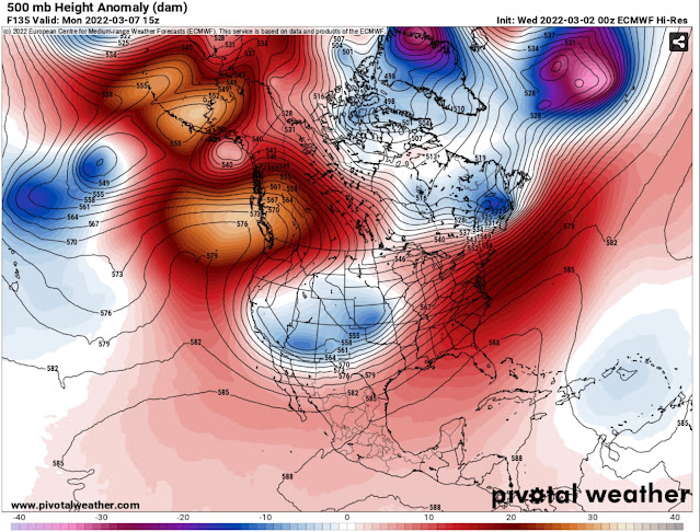
Why is another cold snap happening? The answer can be found in the European model forecast for Wednesday.


Washington is in the black circle. Notice that the ridge (red/orange shade) has broken down and allowed the Arctic air trough (blue/purple shade) to clip the Pacific Northwest. This brief intrusion of Arctic air is what will cause these brief cold temperatures.

Expect biting northerly winds at times from midday Tuesday through Wednesday, also due to the Arctic air moving in. The colder temperatures will be accompanied by partly to mostly sunny skies at times between Wednesday and Friday.

Then, on Saturday, the pattern shifts to a more active one. A wetter and breezier pattern is likely. While details aren’t yet certain, it is likely that it’ll be much wetter. The European model for rain through the next 10 days (ending March 16th) is below.


This forecast says that the lowlands will receive 2-3 inches of rain by the 16th, most from Saturday (12th) onward.

Stay tuned for more updates about the cold snap and wetter pattern!

Friday, March 4, 2022

Calm & Tranquil Start to March

FastCast—Saturday, Mar. 5 to Thursday, Mar. 10:

After an active end to February and showery start to March, a calm and partly sunny weekend is ahead. Expect partly cloudy conditions on Saturday, becoming mostly sunny on Sunday. Clouds and showers return late Monday to Tuesday. Cooler and partly to mostly cloudy conditions will prevail on Wednesday and Thursday. Temperature-wise, expect highs in the upper 40s to low 50s and lows in the low to mid 30s this weekend. Monday and Tuesday will have similar highs, but lows will be in the upper 30s to mid 40s. Wednesday and Thursday will be colder, with highs in the mid 40s and lows near freezing.

———————————————————

Continue reading the full blog below!

A ridge that will develop off the entire Pacific Northwest coast over the weekend will bring tranquil weather to the region. The European model below shows the ridge on Sunday.


This ridge will bring calm weather over the weekend. Without much other weather to report…below is the Weather Underground forecast for Federal Way.


Expect a nice and dry weekend, with showery conditions by Tuesday. Colder conditions, with highs only in the mid 40s are expected on Wednesday and Thursday. Lows near freezing are possible on Sunday, Monday, Thursday, and Friday mornings.

Enjoy the nice weather this weekend!

Tuesday, March 1, 2022

Atmospheric River Recap & A Look Ahead

 FastCast—Wednesday, Mar. 2 to Monday, Mar. 7:

After a thorough drenching thanks to an atmospheric river, Western Washington is slowly beginning to dry out. Most areas south of Seattle received 3-5 inches of rain from Sunday to Tuesday. Amounts of 0.5 to 2 inches were observed north of Seattle, 6-8 inches in the foothills, and large amounts of 6-10 inches fell in the Cascades and Olympics. A weak system will move through on Wednesday, with 0.2 to 0.4 inches of rain around the area. A ridge will build, with drier conditions expected from Thursday afternoon through next Monday. Temperatures will cool from the upper 50s to low 60s on Tuesday to the upper 40s to mid 50s for the remainder of the week and into next week. Expect lows in the mid 30s to low 40s. This dry stretch will allow the rivers to recede by Thursday. See below for some footage of Snoqualmie Falls and the Snoqualmie River on Tuesday.

—————————————————————

Continue reading the full blog below!

A major atmospheric river impacted Western Washington from Sunday to Tuesday, bringing 3-5 inches of rain to the lowlands and 6-10 inches to the foothills and mountains. 

Significant river flooding occurred, with moderate to major flooding on the Snoqualmie River, where I went on Tuesday afternoon. The photos below show Snoqualmie Falls and a flooded road near Duvall.


More footage of the flooding can be viewed here: 

The Falls: https://twitter.com/The_Weatherman2/status/1498830300046004225

River Flooding: https://twitter.com/The_Weatherman2/status/1498876230111674368

As predicted, the rain totals were substantial, with more rain in 3 days than the average amounts for the month of February. Below are rainfall totals in Western Washington from Sunday to Tuesday.


Areas from Seattle southward and in the foothills/mountains received more rain than forecast, with Monday being the 10th wettest day ever at SeaTac Airport (2.97”).

Rivers will begin to recede overnight Tuesday through Wednesday, likely falling below flood stage by Thursday. Check river levels & flood stage here: Advanced Hydrologic Prediction Service

Drier weather will prevail from Thursday to next Tuesday, with a ridge back in place (as seen below from the European model on next Monday).


Enjoy the calmer and drier weather!

Next Storm System Hits Western Washington

  8-26 Video Briefing: Next Storm System Hits Western Washington