FastCast—Tuesday, Mar. 29 to Sunday, Apr. 3:
A calm & uneventful end to March and beginning of April is expected in Western Washington. Expect a slight chance of showers on Tuesday, with highs in the upper 50s to low 60s, and lows in the mid 40s. Wednesday will be slightly cooler, with highs in the mid 50s. Additionally, expect light rain at times on Wednesday, totaling 0.05 to 0.2 inches in the metro area. Areas north of Everett, on the coast, and in the mountains will receive 0.2 to 0.6 inches, with the most in areas between Everett and Mount Vernon, under the Convergence Zone (on Wednesday and Thursday). A few inches of snow are possible at the passes as well. Expect mostly cloudy conditions through the remainder of the week, with a slight chance of rain from Friday to Sunday. Expect highs in the mid 50s and lows in the upper 30s to low 40s through Sunday.
—————————————————————
Continue reading the full blog below!
March has been a mostly calm month around the Pacific Northwest, with near normal rainfall, temperatures, and overall a typical transition toward spring. With little activity in the near future, let’s take a look at the extended climate forecasts for April to June, from the NWS Climate Prediction Center (CPC).
Below are expected temperature trends from April to June.
This pattern is very reminiscent of La Niña, with below average temperatures expected this spring in the Northwest, and significantly above average temperatures over the southern tier of the US.
These forecasts show that we are slowly transitioning toward a more neutral phase (though still leaning toward La Niña). Expect average precipitation in Washington, with below average precipitation for much of the other parts of the Northwest, extending into the Plains and Texas.
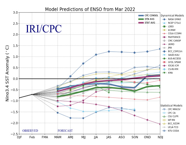
Generally, a trend toward more neutral conditions (horizontal black line in the middle of the graph) by the end of summer. This means generally more average conditions for the Pacific Northwest. However, these forecasts have a difficult time during spring, so stay tuned as these get refined.
Back in the short term…below is the expected rainfall through Friday from the European model.
Expect light rain in the metro area, with only 0.05 to 0.2 inches. The most rain will fall in the Convergence Zone (approximately Everett to Mount Vernon) and in the mountains, with 0.3 to 0.75 inches of rain (most in the mountains).
It was warmer than the forecast of the low 60s. Most areas reached the mid 60s, with some areas, particularly in the southern and eastern parts of the lowlands, reaching the upper 60s (and even the low 70s)! We won’t have temperatures this warm for the foreseeable future, but high temperatures will consistently remain in the 50s.


No comments:
Post a Comment