Monday, October 30, 2023

Atmospheric River Likely to Start November

FastCast--Tuesday, Oct. 31 to Friday, Nov. 3:

After a consistent sunny, dry, and cold pattern, a significant shift is ahead. First off, expect dry conditions with a near-zero chance of rain during peak trick-or-treating times on Halloween. Conditions across the lowlands will be partly cloudy, with temperatures in the low to mid 40s, so bundle up! A noticeable temperature increase is expected over the coming days, with lows in the low to mid 30s one more time on Tuesday morning before high clouds increase and highs reach the mid 50s. Wednesday will be cooler, with thick cloud cover and highs only reaching the upper 40s to low 50s. Subtropical air related to the major pattern change will bring highs on Thursday and Friday to the upper 50s to low 60s. Lows will reach the upper 30s to low 40s on Wednesday morning, but will substantially increase to the upper 40s to low 50s on Thursday and Friday mornings. The pattern will change with a bang, as an atmospheric river moves into the Northwest, bringing significant rain to the lowlands from late Wednesday through early Friday. Forecast models still have some disagreement about rainfall amounts, with the European model suggesting 1-2" for the lowlands and the GFS (American) model suggesting 0.5-1.5", but most from Seattle south. Both forecasts show around 1-1.5" for the metro area within a 36-hour period, which will bring areas of standing water and urban flooding. Additionally, winds will gust 30-40 mph for the North Sound, strongest near the water. Stay tuned over the coming days as details get clearer on this atmospheric river and future storms.

------------------------------------------------------------

Continue reading the full blog below!

The stormiest month of the year will likely begin with an atmospheric river and a pattern change to a wet and stormy pattern, replacing the high pressure and consistent sunny days with frosty mornings. Let's take a look at the forecast!

We'll start with the European model forecast showing water vapor in the atmosphere late Wednesday night. The atmospheric river is clear, aimed at the Northwest.


This is the classic signature of an atmospheric river, sometimes called a "Pineapple Express" in the Northwest. You can see why this moniker was coined, since the plume of moisture (atmospheric river) originates in the region of Hawaii (bottom left of map).

Let's compare this forecast to the UW WRF forecast, also showing water vapor in the atmosphere late Wednesday night.


The UW WRF model agrees with the European in showing an atmospheric river slamming the Northwest. However, the UW WRF shows this atmospheric river going a bit further south than the European forecast. This model typically aligns with the GFS (American) forecast, which currently shows the atmospheric river aimed south of the European model forecast.

Let's compare precipitation totals between the European and GFS models, starting with the European model, showing total rain through Friday morning.


The European model shows this atmospheric river slamming Western Washington. This forecast gives the lowlands 1-2" of rain, with up to 2.5" from Arlington northward. The coast gets 1.5-3", with the Cascades and Olympics picking up 3-5". Even Eastern Washington gets 0.3-0.5", with areas closer to the Idaho border, such as Spokane and Pullman, getting 0.6 to 1". 

Let's take a look at the GFS forecast, also showing rain through Friday morning.


Notice the differences? The GFS forecast shows significantly less rain, with the lowlands picking up 0.5-1.4". This forecast has a prominent rain shadow over the NE Olympic Peninsula, with Everett and Mount Vernon getting around 0.4-0.6". Areas from Seattle south to the Central Willamette Valley (including the coast and mountains) would likely get 0.8-1.5" with this forecast. The heaviest precipitation is roughly south of a line from Salem to Lincoln City, where 2-3" is possible.

Regardless of the difference in forecasts, moderate to heavy rain at times is likely for the entire region between late Wednesday night and early Friday morning. Below is the NWS Weather Prediction Center Excessive Rainfall Outlook for Wednesday to Thursday morning.


The WPC is highlighting a marginal risk of excessive rainfall over Western Washington and extreme NW Oregon. This is due to the threat of standing water, ponding, and urban/small stream flooding because this atmospheric river will bring all its rain within 36 hours. 

Forecasts will likely change over the next couple days. The next blog post will be on Wednesday night, as rain is beginning for the region. Stay tuned for that post, which will be an update on the atmospheric river and what to expect.

We will wrap up tonight's blog with a look at the European EPS forecast for 24-hour rain in the Seattle area. 


Notice how nearly all the ensemble members show 1-1.5" of rain (red outline) from late Wednesday to early Friday. This shows good agreement in the European model's forecast. Additionally, if you look outside the outline and to the right, notice how many ensemble members show other heavy precipitation events in the coming days. Stay tuned as we get more details on what's next!

Saturday, October 28, 2023

Chilly Temperatures Continue, Warming Through the Week

FastCast--Monday, Oct. 29 to Wednesday, Nov. 1:

Sunny and chilly weather will continue across Washington state on Sunday and Monday, with lowland highs in the upper 40s to low 50s. Lows will drop to the upper 20s to low 30s, with some regions dropping to the mid 20s, mainly away from the water and closer to the mountains. On Tuesday morning, lows will drop to the low to mid 30s, with partly cloudy conditions expected and highs increasing to the low to mid 50s. Halloween night will be partly cloudy, with temperatures in the upper 30s to low 40s during trick-or-treating time. Lows on Wednesday morning will drop to the upper 30s to low 40s, with highs in the low to mid 50s. The pattern will be changing significantly by Wednesday, with increasing rain through the rest of the week as multiple storms (and potentially atmospheric rivers) move through the region. Stay tuned to the blog as the forecast gets more refined over the coming days!

-----------------------------------------------------------

Continue reading the full blog below!

The sunny and cold weather will continue for the next couple days across Washington, as we remain under a strong high pressure ridge. However, temperatures will moderate over the coming days, with a stormier pattern expected to begin on Wednesday. Let's take a look at the forecast!

From Sunday to Tuesday, expect lowland highs in the upper 40s to low 50s, with some areas reaching the mid 50s on Tuesday.

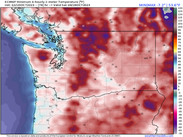
We'll start with the European model forecast for lows on Sunday morning, seen below.


Expect Sunday morning's lows to drop to the upper 20s to low 30s across the lowlands, with some areas (away from the water) dropping to the mid 20s. Eastern Washington will drop to the low to mid 20s, except areas from Yakima to the Tri Cities, where temperatures will only drop to the low 30s. The Willamette Valley will drop to the low to mid 30s.

Next, let's take a look at Monday morning's lows, seen below.


On Monday morning, lows in the lowlands will drop to the low 30s, with some areas dropping to the upper 20s, and some areas near the water remaining in the mid 30s. Eastern Washington will drop to the mid 20s to low 30s, and the Willamette Valley will drop to the low to mid 30s.

An increase in low temperatures is clear on Tuesday morning, as seen below.


On Tuesday morning, expect lowland lows in the low to mid 30s, with areas away from the immediate shorelines still dropping to the low 30s. The Willamette Valley will also drop to the mid 30s, and Eastern Washington will be a bit warmer, with lows dropping to the mid 20s to mid 30s. 

Now, let's take a look at the European EPS forecast showing highs and lows for Seattle and Spokane for the next 2 weeks, starting with the Seattle forecast.


Expect a pattern change to a stormier and more active pattern by midweek, with highs returning to the mid to upper 50s, and lows increasing nearly 20°, to the upper 40s to low 50s. From midweek onward, temperatures will remain above average.

Let's compare this to Spokane's forecast, seen below.


Spokane shows a similar trend, just less pronounced than Seattle. By midweek, "cold" weather is over for awhile, with highs reaching the low 50s and lows increasing to the low 40s. Spokane's temperatures will stay near to slightly above average for the foreseeable future.

Finally, below is the European EPS ensemble forecast showing individual ensemble members' predictions for when and how much rain will fall over the next 2 weeks for Seattle. 


Notice that almost every ensemble member shows multiple periods of moderate to heavy rain through at least the first week (and possibly more) of November.

Stay tuned over the coming days as this pattern gets closer and the forecast gets better defined (and enjoy that sun while you can!).

Wednesday, October 25, 2023

Sub-Freezing Temperatures Ahead, Potential Signs of a Stormy November

FastCast--Thursday, Oct. 26 to Monday, Oct. 30:

After a rainy (and snowy) system moved through the Pacific Northwest from Tuesday to Wednesday, arctic air will filter south, bringing sunny skies, brisk northerly winds, and sub-freezing temperatures. Morning frost is likely across the region most mornings through Monday. Isolated areas of black ice on roadways cannot be ruled out, so be prepared. From Thursday to Monday, expect highs in the upper 40s to low 50s. Lows will be in the mid 30s on Thursday and Friday mornings, except colder in outlying areas and away from the water. Mornings from Saturday to Monday will be the coldest, with lows in the upper 20s to low 30s, coldest in outlying areas and away from the water. If you have sensitive plants, bring them inside! Temperatures look to moderate to near/slightly above average by next week. Skip ahead to the end of the blog for a preview of a potentially stormy beginning of November!

---------------------------------------------------------

Continue reading the full blog below!

The first arctic air of the season is moving into the Pacific Northwest. Under a high pressure ridge, skies will clear and temperatures will get colder. This blog will mainly focus on the upcoming low temperatures, since that will be the coldest time of the day.

However, note that Western Washington will see highs in the upper 40s to low 50s through Monday, with Eastern Washington reaching the upper 30s to low 50s (coldest from I-90 northward, warmest in the lower Columbia Basin).

Let's take a look at the European model forecast for lows on Thursday morning.


On Thursday morning, expect Western Washington's lows to be in the mid 30s, with isolated areas dropping to the low 30s. Eastern Washington will drop to the upper 20s to low 30s, with the Willamette Valley remaining in the upper 30s to low 40s. Mountain towns will drop to the mid to upper 20s.

Next, let's look at the European model forecast for Friday morning's lows.


On Friday morning, expect lows in Western Washington to drop to the low to mid 30s in the lowlands (coldest from Everett north), with outlying areas dropping to the upper 20s. Eastern Washington will dip to the upper 20s to mid 30s, the Willamette Valley will dip to the mid 30s, and mountain towns will drop into the low to mid 20s.

Saturday morning will likely be the coldest morning of this cold snap, as seen in the European model forecast below.


On Saturday morning, expect Western Washington's lows in the upper 20s to low 30s, with outlying areas dropping to the mid 20s. Eastern Washington will drop to the low to mid 20s, the Willamette Valley will reach the low 30s, and mountain towns will drop to the upper teens to low 20s.

We'll end this segment of the blog with the European model forecast for Sunday morning's lows, seen below.


On Sunday morning, expect Western Washington's lows in the upper 20s to low 30s (cooler in outlying areas), with Eastern Washington reaching the low 20s to low 30s (warmest near Yakima and the Tri Cities). The Willamette Valley will drop to the upper 20s to mid 30s, and mountain towns will drop to the low to mid 20s.

Now, we'll switch gears to a look ahead at the beginning of November. Extended forecasts indicate that a potentially wetter and stormier period is ahead. Below is the NWS Climate Prediction Center precipitation outlook for November 2-8.


This outlook shows a 50-60% probability of above average precipitation for the Northwest in the first week of November.

Let's compare this with the European EPS ensemble forecast showing 24-hour precipitation through the first week of November.


Notice how almost every ensemble member shows rounds of moderate to heavy rain starting around November 2nd, continuing through the first week of the month. We will continue to monitor this potential pattern change as we get closer.

For now, stay tuned for more updates on the cold weather, and enjoy the sun and fall foliage while it lasts!

Monday, October 23, 2023

Arctic Air Arrives: First Mountain Snowstorm, Cold Temperatures, and Heavy Rain

Special Note: This is the 600th blog post on The_Weatherman2 Weather Blog!

 FastCast--Tuesday, Oct. 24 to Friday, Oct. 27:

A major weather change is ahead for the Pacific Northwest. Arctic air will move into the region through this week, with a strong frontal system bringing the first snowstorm of the season to the Cascades and Olympics, plus heavy rain to the lowlands. The frontal system will be followed by a weaker system from late Thursday to early Friday. Then, temperatures will drop significantly, with sub-freezing lows expected this weekend. On Tuesday, expect rain in the lowlands, mainly from mid-morning onward, with 0.5-1.3" in the lowlands, except 1.3-1.75" from Everett northward, including normally rain-shadowed areas like Whidbey Island. Rain will be heavy at times on Tuesday evening. As the system moves through, snow levels will plummet to 2,000 feet. Snoqualmie, Stevens, and White Passes will receive 6-12" of snow, with up to 18" at Stevens Pass. Travel will be most challenging from Tuesday evening to midday Wednesday, when the heaviest snow will be falling. Lingering showers will be scattered around the area on Wednesday, and another chance of light rain/light mountain snow exists from late Thursday to Friday morning. Temperatures will be noticeably colder. Through Friday, expect lowland highs in the upper 40s to low 50s, with lows in the mid 30s to low 40s. Sunnier and colder conditions are expected this weekend, so stay tuned. Keep reading below for a full update on the incoming storm and weather change!

------------------------------------------------------------

Continue reading the full blog below!

Since the last blog post, forecasts have come into very good agreement on the arrival of Arctic air into the Pacific Northwest, bringing the first mountain snowstorm and significantly colder temperatures to the entire region, plus heavy rain on Tuesday. Let's dive into the forecast!

First, we will look at the snow forecast for the mountains, since that is the highest-impact part of this event. Below is the European model forecast for snow through late Friday night. 


The European model forecast shows 10-18" of snow at the passes (less will actually accumulate since the ground is still warm due to this being the first snow of the season). The Olympics will get 8-12", and the Blue Mountains will get 4-10". This forecast also shows a chance of 1-3" of snow for Eastern Washington, mainly from I-90 northward.

Next, let's take a look at the NAM high-resolution snow forecast through late Wednesday.


The NAM forecast shows 6-12" at the passes, except up to 18" at Stevens Pass. This forecast agrees with 8-12" for the Olympics and 4-8" for the Blue Mountains. This forecast shows more widespread snow for Eastern Washington, with 2-4" for Wenatchee, the northern Palouse, and the area from Wenatchee to Spokane. Other areas of Eastern Washington, mainly from I-90 northward and along the Idaho border, could get a dusting to 1".

Finally, let's take a look at the ultra-high resolution UW WRF forecast, showing total snow through Wednesday evening.


The UW WRF forecast is very similar to the NAM, showing 6-12" at the passes, 8-12" in the Olympics, and 4-8" in the Blue Mountains. This forecast agrees with enhanced snow around Wenatchee (up to 4-6" in this scenario), along with 1-3" of snow from Banks Lake east to Spokane, mainly from I-90 northward.

Snow won't be the only precipitation falling in this storm. Below 2,000 feet in Western Washington, there will be a decent round of rain, heaviest from Tuesday afternoon to late Tuesday night. Let's take a look at the European model forecast below, showing total rain through Wednesday evening.


This forecast shows 0.7-1" for the lowlands, except 1-1.8" from Everett to Bellingham, including the San Juans and Whidbey Island. The coast will get 1-1.3", and the Willamette Valley will get 0.9-1.3". Note: Remember that this is a rain forecast, and thus all rain in the mountains will fall as snow.

Let's compare this to the GFS model forecast, also showing rain through Wednesday evening.


The GFS forecast shows 0.7-1.5" for the lowlands, focusing the heaviest rain a bit south of the European model, showing it from Tacoma to Oak Harbor, with up to 1.8" in the typically rain-shadowed areas of Port Townsend and Sequim. This forecast shows 1-1.5" on the coast and 0.4-0.7" in the Willamette Valley.

Now, let's take a look at temperatures. High temperatures will be noticeably colder over the next few days. We'll start below with the European model forecast for highs on Tuesday.


Expect highs in Western Washington in the upper 40s to low 50s, Eastern Washington in the mid 40s to mid 50s, and mountain towns in the upper 30s to low 40s.

Next, Wednesday's highs from the European model, seen below.


Western Washington will reach the mid 40s to low 50s, while Eastern Washington, mainly north of the Tri-Cities, will only reach the mid 30s to mid 40s. The Tri-Cities and Walla Walla will reach the low to mid 50s. Mountain towns will stay in the low to mid 30s.

Below are highs on Thursday, from the European model.


The lowlands will remain in the upper 40s to low 50s on Wednesday, with Eastern Washington in the mid 30s to low 40s north of I-90 and in the mid 40s to low 50s south of I-90. Mountain towns remain in the low to mid 30s.

Now, let's take a look at expected low temperatures, from the European model, starting with lows on Wednesday morning.


Wednesday morning's lows will drop to the mid 30s to low 40s in Western Washington, the low 30s to mid 40s in Eastern Washington, and the upper 20s to low 30s in the mountains.

Next, Thursday morning's lows from the European model.


Thursday morning will be colder, with lows in Western Washington dropping to the low to mid 30s, coldest in outlying areas. Eastern Washington will drop to the low 30s, except the mid to upper 30s in the Columbia Basin. Mountain towns will drop to the low to mid 20s.

We'll end this blog with a preview of the coldest temperatures for Western Washington, likely Saturday morning. Skies will clear late Friday, bringing clear and cold nights this weekend under a strong high pressure ridge (the Arctic high). Below is the European model forecast for Saturday morning's lows.


On Saturday morning, expect lows in Western Washington to drop to the upper 20s to low 30s, with the first frost likely for the entire region. Eastern Washington will be quite cold, with lows in the low to mid 20s, except in the upper 20s to low 30s from the Tri-Cities to Wenatchee. Mountain towns will drop to the upper teens to low 20s.

Lots of weather changes are ahead, and it'll feel more like winter than fall by this weekend! Stay tuned as we continue to monitor the latest forecast!

Friday, October 20, 2023

Uncertainty Over Upcoming Pattern Change

FastCast--Saturday, Oct. 21 to Tuesday, Oct. 24:

A general cooling pattern is ahead for the Northwest over the coming days. In Western Washington, cooler and cloudier weather is expected for the next few days. Expect highs over the weekend and into next week to remain in the upper 50s to low 60s, with lows cooling from the upper 40s to low 50s this weekend to the low to mid 40s next week. Showers will move into the region later on Tuesday, but much of the forecast beyond then remains uncertain. Additionally, expect fog and areas of low visibility at times through Monday.

-------------------------------------------------------------

Continue reading the full blog below!

An uncertain future is ahead for the Pacific Northwest, as weather models continue to disagree on the upcoming forecast. Let's take a look at some forecast models.

First, we will take a look at the GEFS (ensemble version of the GFS) seen below, showing late Tuesday night.


Notice the large green area over the Pacific Northwest. That shows an upper-level trough over the region, which will bring colder and likely more active weather.

Let's compare this to the EPS forecast for a similar time.


The EPS shows a much weaker trough over the Northwest, bringing less cold and generally calmer weather. 

Now, we can compare these upper-air forecasts to the temperature forecasts for Seattle and Spokane. Let's start with the forecasts for Seattle (starting with EPS).


The EPS forecast for Seattle shows a general cooling trend through the middle of next week, before temperatures remain steady through the end of the month.

Let's compare this to the GEFS forecast for Seattle.


The GEFS forecast is noticeably cooler, but also brings cooler temperatures later than the EPS. 

Now, let's take a look at the forecasts for Spokane, starting with the EPS.


The EPS shows a significant cooling trend for Spokane through the middle of next week, with colder temperatures late next week, then moderating slightly through the end of the month.

Let's compare Spokane's EPS forecast to the GEFS forecast, seen below.


The GEFS forecast for Spokane shows the potential for frigid temperatures in a strong trough. Lows could reach as low as 20° in this stronger trough scenario.

However, much remains to be seen over the next few days. Stay tuned to the blog for more updates as the forecast gets more accurate!

Tuesday, October 17, 2023

Brief Warmth, Then a Significant Cooldown

FastCast--Wednesday, Oct. 18 to Tuesday, Oct. 24:

With a strong atmospheric river directed into British Columbia, warm southerly flow will bring mostly sunny conditions to Western Washington on Wednesday and Thursday, with highs increasing significantly to the upper 60s to low 70s. However, from Friday onward, temperatures will decline significantly, ending up below average by next week. On Friday, expect mostly cloudy skies with highs dropping to the low to mid 60s. Cloudy conditions with a chance of showers will prevail from Saturday to Monday, with highs in the upper 50s to low 60s. From Wednesday to Sunday, expect lows in the upper 40s to low 50s. On Monday, expect lows to drop to the mid 40s. By Tuesday, the chance of showers will increase, and highs will drop to the upper 40s to low 50s, with lows in the upper 30s to low 40s. These colder temperatures will continue into next week, so stay tuned for updates.

---------------------------------------------------------------

Continue reading the full blog below!

Washington will experience a few more days of above average temperatures, before a significant cooldown will bring colder temperatures to the Pacific Northwest starting next week. Let's take a look at the forecast!

Let's start with the forecast for high temperatures from the European model, starting with Wednesday's highs.


Expect lowland and Willamette Valley highs in the upper 60s to low 70s, with similar highs in Eastern Washington. Coastal highs will reach the low to mid 60s. Notice cooler highs from Bellingham northward, as a strong atmospheric river impacts British Columbia. Clouds associated with this atmospheric river will bring cooler temperatures to Whatcom, San Juan, and Clallam Counties. 

Next, let's look at Thursday's highs, also from the European model.


On Thursday, expect lowland and Willamette Valley highs in the upper 60s to low 70s, with Eastern Washington reaching the upper 60s to mid 70s, the coast reaching the low to mid 60s, and areas under the atmospheric river (North Coast & NW Interior) reaching the low 60s.

Friday's highs will cool west of the Cascades, but remain warm to the east. The European model forecast is below.


On Friday, expect lowland highs in the upper 50s to low 60s, coastal highs in the low to mid 60s, Willamette Valley highs in the mid 60s to low 70s, and Eastern Washington's highs in the upper 60s to mid 70s. Areas along the Strait of Juan de Fuca and in the NW Interior will remain in the mid 50s to low 60s.

On Saturday, temperatures will continue to decrease in the lowlands, while remaining warm in Eastern Washington, as seen below.


On Saturday, lowland highs will decrease to the upper 50s to low 60s, with the Willamette Valley reaching the low to mid 60s, and the coast reaching the upper 50s. Eastern Washington will remain warm, with highs reaching the upper 60s to mid 70s.

Now, let's take a look at the reason for both the warm temperatures on Wednesday and Thursday and the cooler temperatures in the state's northwest corner. A potent atmospheric river is aimed directly at Southern British Columbia, barely clipping NW Washington. The European model forecast shows total rain from this atmospheric river.


Notice 0.1-0.2" of rain from Snohomish County southward in Western Washington. Most of this rain has already fallen. Areas from Everett to Bellingham could get 0.2-0.4" of rain. The atmospheric river has a very sharp cutoff on its south side. From Forks northward on the coast and north of a line from Orcas Island to Lynden will get 0.5-2.5" of rain. Parts of the Vancouver Island coast (like Tofino) will get a staggering 8-12" of rain in under 3 days, with Metro Vancouver, eastern Vancouver Island, and the Sunshine Coast getting 2.5-5".

The contrast is most notable between Bellingham and Vancouver, 45 miles as the crow flies. Bellingham will get 0.3", while Vancouver will get up to 3.5"!

We'll round out the blog by looking at the extended forecasts for Seattle and Spokane, seen on the European EPS model.

First, Seattle, seen below.


Notice warmth and above average temperatures until around Monday, then a significant change to below average conditions, with highs in the low to mid 50s and lows in the upper 30s to mid 40s.

A similar situation is seen in the forecast for Spokane, seen below.


In Spokane, highs will be warmer than Seattle (through Saturday), then cooler than Seattle (Monday onward), with lows remaining colder than Seattle. By next week, Spokane's highs will be in the mid 40s to low 50s, with lows in the low to mid 30s. The first frost is likely for Eastern Washington next week. (Add 3-5° to these temperatures for the Columbia Basin).

Stay tuned for more information as colder fall weather arrives in the Pacific Northwest.

Sunday, October 15, 2023

Monday Storm: Strong Cold Front, Chance of Thunderstorms, and Heavy Rain

FastCast--Monday, Oct. 16 to Thursday, Oct. 19:

A potent and fast-moving storm system will move through Western Washington on Monday. The storm will begin with a strong cold front (with heavy rain at times) on Monday morning, during the commute. Then, from late morning to late evening, strong post-frontal showers will move through Western Washington, with a chance of thunderstorms across the region. A strong convergence zone will develop over Island, Skagit, and Whatcom Counties, and heavy showers will move through most of the lowlands in the afternoon. These showers will have heavy rain and gusty winds, with the potential for lightning, thunder, and small hail. Winds will pick up as well, gusting 25-35 mph in the lowlands and 35-45 mph in the North Sound, strongest on Whidbey Island. Rain totals will likely be in the 0.4-0.6" range in the lowlands, with some areas getting less, and areas under heavy showers getting more. Some showers will linger into Tuesday. Expect highs on Monday and Tuesday in the upper 50s to low 60s, with lows in the upper 40s to low 50s. On Wednesday, clouds will decrease, followed by sunny conditions on Thursday. With an atmospheric river to the north in BC, southerly flow will allow the lowlands to warm up significantly, with highs reaching the upper 60s to low 70s, with lows in the upper 40s to low 50s.

----------------------------------------------------------

Continue reading the full blog below!

A potent weather system is ahead for Western Washington on Monday, with the main impacts being rain (heavy at times), a chance of thunderstorms, and localized gusty winds. Let's take a look at the forecast!

Rain will come in 2 waves, with the initial cold front from 7-10 AM Monday, bringing heavy rain at times and locally windy conditions. Then, from 11 AM-7 PM, there is a region-wide chance of thunderstorms in heavy post-frontal showers moving onshore. Winds will be breezy (25-35 mph) in the lowlands and windy (35-45 mph) in the North Sound.

First, let's take a look at the European model forecast for rain through Monday night.


The European model shows most of the lowlands (except around Everett) getting 0.6-1" of rain, with up to 1.5" in Skagit County. Areas from Olympia south get 0.5-0.8", and the coast gets 1-1.5". The Olympics get up to 3", with 1-2" in the Cascades.

Let's compare this to the high-resolution NAM model, also showing rain through Monday night.


The NAM forecast shows less rain for the entirety of the lowlands, with 0.2-0.5" expected in this forecast. Areas from Mount Vernon northward get 0.5-0.75", with the coast picking up 0.6-1.2", and the Olympics & Cascades getting 2-4". 

Let's compare one more time to the HRRR high-resolution forecast, also through Monday night.


The HRRR sides more with the European than the NAM, showing 0.4-0.6" for the lowlands, but mainly south of Seattle. The HRRR shows a typical rain shadow NE of the Olympic Peninsula, but this will likely not happen on Monday due to Convergence Zone activity in that area. This forecast gives the coast 0.5-1", and gives the mountains 1-3".

Now, let's take a look at the thunderstorm potential on Monday. Thunderstorms are most likely in heavy post-frontal showers from late morning to late evening. Below is the NAM high-resolution forecast for CAPE (measure of instability in the atmosphere). More instability (CAPE) = higher chance of thunderstorms.

The NAM forecast below is for Monday afternoon.


The NAM shows high CAPE values of 250-1000 across the lowlands on Monday afternoon, highest from Seattle north to Vancouver BC.

Let's compare this to the HRRR high-resolution forecast, seen below (also for Monday afternoon).


The HRRR forecast shows CAPE values of 200-750 across the region, highest west of Olympia and from Port Townsend to Bellingham. 

Finally, let's take a look at the UW WRF forecast, also showing CAPE on Monday afternoon.


The UW WRF forecast agrees, showing CAPE values of 200-600 across Western Washington on Monday afternoon.

So...the bottom line is that lightning & thunder are possible in any shower from late Monday morning to Monday evening. Heavy rain, sudden drops in visibility, gusty winds, and small hail are also possible in any showers. Remember to go indoors if you hear thunder, and stay inside for at least 30 minutes.

We will end the blog with a look at the extended forecast, which has some interesting things to note. This is the Seattle forecast from the European EPS model.


Notice near-average highs on Monday & Tuesday, followed by significant warmth (low 70s possible) on Wednesday and Thursday. Then, from Friday to Monday, temperatures drop steadily. By next week, highs will likely struggle to get out of the mid 50s. Also, notice low temperatures drop to the low to mid 40s next week after remaining steady in the low 50s this week. We have a lot to watch in the extended forecast, so stay tuned!

Friday, October 13, 2023

2023 Annular Solar Eclipse Sky Cover Forecast

FastCast--Saturday, Oct. 14 to Wednesday, Oct. 18:

After warm days on Thursday and Friday, clouds and showers have returned to the Pacific Northwest. Continue reading the blog below for a sky cover forecast for the annular solar eclipse on Saturday morning. Expect a chance of showers on Saturday in the lowlands, most likely in the early morning and in the evening. Rain will be light, generally around 0.1". A break in the rain is likely on Sunday, with cloudy skies continuing. A stronger system will move through on Monday, with up to 0.75" of rain, winds gusting up to 30 mph, and some periods of heavy rain. Some showers will linger on Tuesday before rain leaves the area. Wednesday will begin cloudy but end mostly sunny. From Saturday to Tuesday, expect highs in the low 60s and lows in the upper 40s to low 50s. On Wednesday, expect highs increasing to the mid to upper 60s, with lows in the mid to upper 40s.

------------------------------------------------------

Continue reading the full blog below!

On Saturday, an annular solar eclipse (known as a "ring of fire eclipse" due to how the moon obscures all but a ring of the sun) will move across the United States, with maximum totality beginning over the Central Oregon Coast and moving SE across the Desert Southwest, then over Texas, and exiting the US near Corpus Cristi on the Southern TX Gulf Coast. The eclipse will enter the US on the Oregon Coast around 9:13 AM PDT.

The map below from the Great American Eclipse website shows the eclipse's path and the path of totality.


Washington will be in the 70-80% totality area, with the highest levels of totality south of a line from Cape Flattery to Walla Walla. However, prospects of seeing the eclipse from Washington look grim.

Let's take a look at multiple sky cover forecasts, showing cloud cover around 9 AM.

The first forecast is the European model, seen below.


The European model shows most of Washington under complete cloud cover, with breaks in the clouds from Seattle to Bellingham and over most of the Columbia Basin (but not Yakima, Ellensburg, or areas south of the Tri Cities).

Let's compare this to the GFS forecast, seen below.


The GFS forecast shows a much cloudier picture. The only areas of partially clear skies are around the Tri Cities, near Ellensburg, and potentially near Port Townsend and Sequim, but all of those are only partially clear skies.

Next, let's take a look at the NAM high-resolution forecast.


The NAM shows the least cloudy forecast for Washington, with an area of mostly clear skies from Port Angeles to Bremerton to Tacoma and from Everett northward. In Eastern Washington, this forecast shows nearly clear skies from near Leavenworth to Clarkston.

Next, the HRRR high-resolution forecast.


The HRRR shows a cloudy forecast, with an odd narrow area of clear skies (with relatively low population) from near Mount Baker toward Pullman.

Finally, we'll end with the NOAA FV3 forecast, also showing cloud cover.


This forecast shows near total cloud cover in Western Washington, with some areas of partially clear skies north of Spokane, in parts of SE Washington, including near Clarkston, around the Tri Cities, and in extreme north-central Washington, north of the Methow Valley.

Overall, prospects for seeing the eclipse are very low in Western Washington and only somewhat better in Eastern Washington. The best resource to see cloud cover (besides looking outside) will be the UW Atmospheric Sciences Satellite Loop, which updates frequently and shows cloud cover over Washington.

Next Storm System Hits Western Washington

  8-26 Video Briefing: Next Storm System Hits Western Washington