FastCast--Thursday, Oct. 26 to Monday, Oct. 30:
After a rainy (and snowy) system moved through the Pacific Northwest from Tuesday to Wednesday, arctic air will filter south, bringing sunny skies, brisk northerly winds, and sub-freezing temperatures. Morning frost is likely across the region most mornings through Monday. Isolated areas of black ice on roadways cannot be ruled out, so be prepared. From Thursday to Monday, expect highs in the upper 40s to low 50s. Lows will be in the mid 30s on Thursday and Friday mornings, except colder in outlying areas and away from the water. Mornings from Saturday to Monday will be the coldest, with lows in the upper 20s to low 30s, coldest in outlying areas and away from the water. If you have sensitive plants, bring them inside! Temperatures look to moderate to near/slightly above average by next week. Skip ahead to the end of the blog for a preview of a potentially stormy beginning of November!
---------------------------------------------------------
Continue reading the full blog below!
The first arctic air of the season is moving into the Pacific Northwest. Under a high pressure ridge, skies will clear and temperatures will get colder. This blog will mainly focus on the upcoming low temperatures, since that will be the coldest time of the day.
However, note that Western Washington will see highs in the upper 40s to low 50s through Monday, with Eastern Washington reaching the upper 30s to low 50s (coldest from I-90 northward, warmest in the lower Columbia Basin).
Let's take a look at the European model forecast for lows on Thursday morning.
On Thursday morning, expect Western Washington's lows to be in the mid 30s, with isolated areas dropping to the low 30s. Eastern Washington will drop to the upper 20s to low 30s, with the Willamette Valley remaining in the upper 30s to low 40s. Mountain towns will drop to the mid to upper 20s.
Next, let's look at the European model forecast for Friday morning's lows.
On Friday morning, expect lows in Western Washington to drop to the low to mid 30s in the lowlands (coldest from Everett north), with outlying areas dropping to the upper 20s. Eastern Washington will dip to the upper 20s to mid 30s, the Willamette Valley will dip to the mid 30s, and mountain towns will drop into the low to mid 20s.
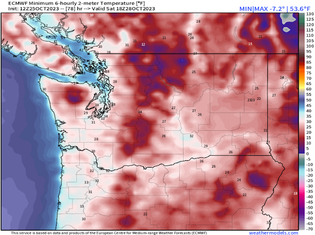
Saturday morning will likely be the coldest morning of this cold snap, as seen in the European model forecast below.
On Saturday morning, expect Western Washington's lows in the upper 20s to low 30s, with outlying areas dropping to the mid 20s. Eastern Washington will drop to the low to mid 20s, the Willamette Valley will reach the low 30s, and mountain towns will drop to the upper teens to low 20s.
We'll end this segment of the blog with the European model forecast for Sunday morning's lows, seen below.
On Sunday morning, expect Western Washington's lows in the upper 20s to low 30s (cooler in outlying areas), with Eastern Washington reaching the low 20s to low 30s (warmest near Yakima and the Tri Cities). The Willamette Valley will drop to the upper 20s to mid 30s, and mountain towns will drop to the low to mid 20s.
Now, we'll switch gears to a look ahead at the beginning of November. Extended forecasts indicate that a potentially wetter and stormier period is ahead. Below is the NWS Climate Prediction Center precipitation outlook for November 2-8.
This outlook shows a 50-60% probability of above average precipitation for the Northwest in the first week of November.
Let's compare this with the European EPS ensemble forecast showing 24-hour precipitation through the first week of November.
Notice how almost every ensemble member shows rounds of moderate to heavy rain starting around November 2nd, continuing through the first week of the month. We will continue to monitor this potential pattern change as we get closer.
For now, stay tuned for more updates on the cold weather, and enjoy the sun and fall foliage while it lasts!


No comments:
Post a Comment