Friday, March 29, 2024

Beautiful Few Days & Warmer Temperatures Ahead

 FastCast--Saturday, March 30 to Thursday, April 4:

A high pressure ridge will bring beautiful weather to the Pacific Northwest over Easter weekend and into the first couple days of April. Expect a mostly sunny Easter weekend, with highs in the lowlands in the upper 50s in the north to the low to mid 60s in the south. Lows will be a tad bit chilly, likely in the upper 30s to mid 40s. By Monday, highs will increase to the mid 60s in the lowlands, further increasing to the upper 60s on Tuesday. A system will move in by Wednesday, and high temperatures will crash by 10-20°. Additionally, this will bring a chance of showers on Wednesday for the lowlands. Thursday will be partly sunny, with highs in the mid 50s. Expect lows from Monday to Thursday to be in the mid 30s to mid 40s.

----------------------------------------------------------------

Continue reading the full blog below!

A beautiful Easter weekend is ahead for the Northwest due to a large high pressure ridge. This will bring warmer temperatures and mostly sunny conditions!

First, let's take a look at the NWS NBM forecast for highs on Saturday.


Expect lowland highs in the mid to upper 50s from Everett northward and in the low 60s from Everett southward. The coast will reach the mid to upper 50s, the Willamette Valley will reach the low to mid 60s, and Eastern Washington will reach the mid 50s to mid 60s.

Next, let's take a look at highs on Easter Sunday, also from the NWS NBM forecast.


Expect Easter Sunday highs to reach the low 60s across the lowlands, the upper 50s on the coast, the low to mid 60s in the Willamette Valley, and in the upper 50s to mid 60s in Eastern Washington.

On Monday, temperatures will increase across the state. Below is the NWS NBM forecast.


There's a noticeable increase (except on the coast). The lowlands will reach the mid 60s, with isolated areas in the upper 60s. The coast will actually cool down to the low to mid 50s. The Willamette Valley will reach the mid to upper 60s, and Eastern Washington will reach the mid 60s to mid 70s (warmest on the western side of the Columbia Basin).

This warmth is all due to a strong high pressure ridge that will be centered over the Northwest. Below is the European model forecast showing the ridge on Monday.


This forecast shows the ridge centered just offshore of Washington, a great location for nice warm conditions that aren't too hot. Enjoy the pleasant Easter weekend & warm start to April!

Monday, March 25, 2024

Stormy Few Days Ahead, Warmer by Easter

 FastCast—Tuesday, March 26 to Saturday, March 30:

A storm moving into the region on Wednesday will bring widespread rain, mountain snow, and some breezier conditions to the Pacific Northwest, followed by what is looking to be a partly to mostly sunny Easter weekend. Tuesday will be on the cloudy side in the morning, with some clearing in the afternoon. Wednesday will be overcast with rain at times throughout the day, and Thursday will be mostly cloudy with a chance of showers (and a slight chance of thunderstorms). Expect the most rain to fall on Wednesday, with totals by late Thursday in the lowlands reaching 0.5-1”. Highs from Tuesday to Thursday will be in the low to mid 50s, with lows in the upper 30s to low 40s. Mountain areas above 3,000 feet have a chance to see up to 10-14” of snow by Thursday, with Snoqualmie Pass receiving less. By Friday, conditions will become partly to mostly sunny, continuing that way into the weekend. Highs on Friday and Saturday will be in the upper 50s to low 60s, with lows in the mid 30s (outlying areas) to low 40s.

———————————————————————

Continue reading the full blog below!

A wet couple days are ahead before a sunnier and somewhat warmer Easter weekend. Let’s take a look at the forecast!

Let’s start with the European model forecast for total rain through Thursday. Most rain will fall on Wednesday, with a chance of showers lingering into Thursday.


This forecast shows the lowlands receiving 0.8-1.5” of rain, with 1.5-3” on the coast and 0.2-0.6” in Eastern Washington.

Let’s compare this to the higher resolution NWS NBM forecast, seen below, also showing total rain through Thursday.


This forecast is a bit drier for the lowlands, showing 0.5-0.8” of rain in total, with 1.5-2.5” on the coast, and 0.1-0.4” in Eastern Washington.

Now, let’s take a look at mountain snow. Snow levels will remain right around 3,000 feet with this storm, so areas like Snoqualmie Pass will likely receive mostly rain/snow mix, with some periods of snow. Higher passes, like Stevens and White, will remain all snow.

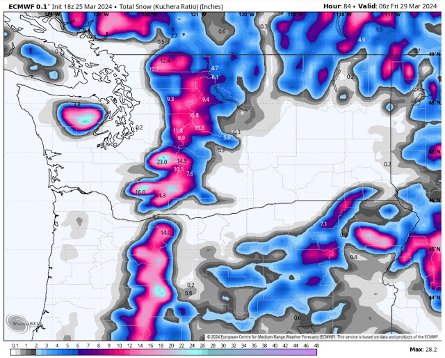
Below is the European model forecast for total snow through Thursday.


This forecast shows Stevens and White Passes (along with areas such as Paradise, Crystal Mountain, and Mount Baker) getting 10-14” of snow through Thursday. Most of this snow will fall on Wednesday. Due to the snow level, Snoqualmie Pass will likely only receive 2-4”, though sustained heavier precipitation could lead to higher snow amounts. Regardless, travel through the mountains with care on Wednesday.

One more potential with this storm is a chance of thunderstorms on Thursday. Below is the European model lightning forecast for Thursday afternoon.


This forecast shows a chance of thunderstorms across almost all of Eastern Washington (best chances) and in Western Washington, from Olympia northward. Again, this is a slight chance, but remember that any shower on Thursday, especially in the afternoon, has a chance of being a thunderstorm.

Now, let’s switch gears and take a look at the extended forecast for Easter weekend. Below is the European Ensemble forecast, showing the upper air pattern on Sunday.


Notice the (red) high pressure ridge over British Columbia…that is what will bring a somewhat warmer and sunnier Easter to the Northwest. If this ridge was further south, it could bring a warm stretch like we saw in mid-March. This shows how important the placement of a ridge is.

What kind of “warmth” are we talking about here? Below is the NWS NBM forecast for highs on Easter Sunday.


This forecast shows lowland highs in the low 60s, with Eastern Washington reaching the mid 60s. This would be a beautiful Easter Sunday, so stay tuned for more information on this potential warmup and the potential for warmer conditions by next Monday.


Thursday, March 21, 2024

Wetter & Cooler Weather Ahead Through Next Week

FastCast--Friday, March 22 to Monday, March 25:

Wetter and cooler weather will continue across the Northwest through next week. On Friday, multiple rounds of showers will move through Western Washington, with a potential for thunderstorms, mainly from Friday evening through Saturday. Rain will be heaviest from Tacoma south and from Everett north. Rain totals through Monday in the lowlands will likely be in the 0.4-0.8" range, with isolated higher totals possible. The mountain passes will receive 2-6" of snow through Monday. Through Monday, expect highs in the mid 50s (except the upper 40s to low 50s on Monday), with lows in the low to mid 40s.

------------------------------------------------------------------

Continue reading the full blog below!

After a couple days of showery and cloudy weather across the lowlands, more of the same is expected through the weekend and into early next week.

Let's start by taking a look at the European model forecast for total rain through Sunday night.


Generally, expect 0.4-0.8" across the lowlands, except up to 1" around northern Island and Skagit Counties. The coast will receive 0.4-1", with 0.1-0.5" in Eastern Washington.

Next, let's take a look at the total snow forecast through Sunday night, from the European model.


For the passes, expect 2-6" of snow, with a slight chance of snow for areas around Spokane and Pullman. 

Now, let's take a look at the forecast for potential thunderstorms on Friday evening. Below is the HRRR high-resolution forecast for lightning potential late Friday evening.


This forecast shows lightning potential for most of the area from Everett south. The highest potential for heavy showers or potential thunderstorms will be from Friday evening into the night.

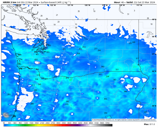
There is potential that heavy showers and potential thunderstorms could continue across the region on Saturday. Below is the HRRR forecast showing instability in the atmosphere (known as CAPE) on Saturday afternoon.


This forecast shows CAPE values of 200-500 across most of the central and southern parts of Washington, with northern Oregon also having decent instability potential.

Finally, let's take a look at how much rain the rounds of moderate to heavy showers could produce, as seen in the HRRR high-resolution forecast for rain through late Saturday.


This forecast shows 0.35-0.5" for most of the lowlands, except 0.5-1" from Olympia to Tacoma and 0.5-0.75" for Whatcom and Skagit Counties. The coastal areas get 0.5-0.9" in this forecast, with 0.1-0.5" in Eastern Washington (most near Spokane).

Be aware for potential heavy showers and a slight chance of thunderstorms from Friday evening through Saturday!

Sunday, March 17, 2024

Warmth Continues Through Tuesday, Then Cooler Weather Returns

 FastCast--Monday, March 18 to Thursday, March 21:

Beautiful spring weather will continue across the region on Monday and Tuesday, with sunny conditions and lowland highs reaching the upper 60s to low 70s. Tuesday may have some partly cloudy conditions in the morning and late evening. Expect morning lows on Monday and Tuesday to be in the low to mid 40s. On Wednesday, conditions will get cloudy and there will be a large drop in temperatures, with highs plummeting to the low to mid 50s. Similar conditions will exist on Thursday. Showers are possible at times on Wednesday and Thursday as cooler and wetter weather returns. 

----------------------------------------------------------

Continue reading the full blog below!

It was an incredible weekend across the Pacific Northwest, as a huge ridge of high pressure dominated the weather pattern, bringing record-breaking highs in the low to mid 70s for Seattle, and in the upper 60s to low 70s for most of the remainder of the area. Very nice conditions will continue on Monday and Tuesday, but changes are afoot later in the week. Let's take a look at the forecast!

First, let's take a look at the NWS NBM high-resolution forecast for highs on Monday.


Expect lowland highs in the mid to upper 60s (coolest closer to the water). There's a decent chance that areas east of I-5 and south of Tacoma will reach the low 70s. The coast will continue cooling, remaining in the mid 50s to low 60s. The Willamette Valley will be quite warm, in the mid 70s (localized upper 70s possible), while Eastern Washington will reach the upper 60s to mid 70s.

These temperatures are quite abnormal, and although Monday will be a touch cooler for Western WA than the weekend, it's still quite above normal. Below is the European model forecast showing temperature departure from average on Monday afternoon.


Across Western Washington, temperatures will be 10-15° above average, with the Willamette Valley and Eastern Washington being 15-20° above average, quite an anomaly for March! Additionally, areas in the mountains are a staggering 20-25° above average. I wouldn't be surprised to see a significant lessening of the snowpack due to this warm spell.

Next, let's take a look at Tuesday's highs, on the NWS NBM model.


Temperatures will begin cooling west of the Cascades on Tuesday, with the lowlands reaching the mid to upper 60s, Willamette Valley reaching the upper 60s to low 70s, and the coast only reaching the mid 50s. Eastern Washington will be warming as the heat moves east, with highs reaching the upper 60s near Spokane to mid to upper 70s near the Tri-Cities and Yakima.

By Wednesday, major temperature changes are expected, as seen below on the NWS NBM forecast.


Major temperature declines are expected, with highs in the lowlands only reaching the mid 50s, the low 50s on the coast, and the upper 50s in the Willamette Valley. Even Eastern Washington will cool significantly, with highs dropping to the upper 50s to upper 60s. Note that the warmer temperatures have moved further east, with the Boise area reaching the low 70s.

A great way of visualizing the temperature change from Tuesday to Wednesday is the 24-hour temperature change forecast, shown below from the European model.


This forecast, showing temperature difference between Tuesday afternoon and Wednesday afternoon, shows a decrease of 10-20° across most areas west of the Cascades, in the mountains, and on the east slopes. Most of Eastern Washington will decrease by 5-10° as well.

What's fueling this big decrease in temperatures mid-week? The overall pattern is changing significantly. We will go from ridging, bringing sunny weather and warm temperatures, to troughing, bringing cooler, cloudier, and wetter weather. Let's take a look at how this looks on forecast models. Below is the European ensemble forecast for Monday.


Notice the massive ridge over the Northwest and SW Canada. This large ridge is what is causing the beautiful, warm weather we've been having.

Now, let's take a look at this same view by Friday.


This is a complete change from earlier in the week, with the massive ridge replaced by a strong trough. This is the source of the big decline in temperatures and return to more active weather.

Stay tuned over the next few days as we determine what kind of stormier weather is ahead later this week and into the weekend...but enjoy the next 2 days of sun!

Thursday, March 14, 2024

Significant Warmup as Spring Weather Arrives in the Northwest

FastCast--Friday, March 15 to Tuesday, March 19:

A significant warmup is expected as spring weather arrives in the Pacific Northwest. A large high pressure ridge will build over the Pacific Ocean, just offshore of the Northwest and British Columbia. This will deflect systems away from the region, bringing days of mostly sunny and warm conditions. Temperatures will increase each day. Highs will reach the low to mid 60s on Friday, then increase to the upper 60s to low 70s on Saturday and Sunday, making for a beautiful weekend! Monday will be in the mid to upper 60s, with temperatures remaining in the low to mid 60s on Tuesday. Expect conditions this entire time to be mostly sunny, with some partly cloudy conditions on Friday morning and Tuesday afternoon. With sunny days and clear nights, morning lows will be chilly compared to afternoon highs. Expect lows in the upper 30s to mid 40s. This will likely be the warmest weather in Seattle since mid-October 2023!

---------------------------------------------------------------

Continue reading the full blog below!

With a large ridge of high pressure building offshore, an extended period of warm spring weather is ahead across the Northwest. Let's take a look at the forecast!

First, a look at the pattern causing this warmup. The ridge is seen below on the European model upper-air forecast.


Notice the massive high pressure ridge centered just offshore and over extreme western British Columbia. This is part of an "Omega block" pattern, as the positioning of the two troughs (greenish circles) and the large ridge create an image similar to the Greek letter Omega (Ω).

Now, let's take a look at the effects of that high pressure ridge...our warm spring weather! We will be using the high-resolution National Weather Service National Blend of Models (abbreviated to NWS NBM) forecast for the next few days.

Let's start with the NWS NBM forecast for Friday's highs.


On Friday, expect Western Washington to reach the low to mid 60s, with the mid 60s in the Willamette Valley and the upper 50s to low 60s in Eastern Washington.

The real fun begins on Saturday, with the warmest temperatures since mid-October. I think it's a safe bet that most people will be getting outside and enjoying this. Below is the NWS NBM forecast for Saturday's highs.


This will be an amazing day across the state! Expect lowland highs in the upper 60s to low 70s, with the coast even reaching the mid 60s! Eastern Washington will climb into the mid to upper 60s, with the Willamette Valley reaching the upper 60s to low 70s as well.

Sunday will be almost the exact same as Saturday, as seen below.


The lowlands and Willamette Valley again reach the upper 60s to low 70s on Sunday, with Eastern Washington reaching the mid 60s to low 70s. The only noticeable difference is that the coast will cool ever so slightly, down to the upper 50s to low 60s.

Expect warm and pleasant weather to continue for the majority of the region through at least Tuesday, before we start to cool down and get cloudier.

Finally, to prove how nice it will be, take a look at the rain forecast through Tuesday night from the European model.


Notice that the entire region has virtually zero rainfall through Tuesday (something that will likely continue into Wednesday as well). 

One thing to note about a long sunny & dry stretch in spring is that there will likely be a pollen explosion, so be ready for some allergy flareups over the next 5+ days.

Enjoy this somewhat unusual stretch of sunny and warm weather across the Northwest! And, as always, remember that the area waterways are EXTREMELY cold (but why would you want to swim in March, anyways?). Stay tuned for updates on our warm temperatures!

Friday, March 8, 2024

Weekend Storm, Potential for Big Changes Ahead

 FastCast--Saturday, Mar. 9 to Friday, Mar. 15:

A weekend storm will bring strong winds, rain, and snow to the region from Saturday to Sunday, with an additional system ahead from Monday to Tuesday. Generally, expect winds gusting 30-40 mph across the lowlands, with some areas near the water gusting up to 45 mph. Winds will likely peak midday to afternoon Saturday. The coast and North Sound will gust up to 50 mph. Expect 0.5-0.8" of rain across the region through Sunday, with 5-10" of snow at the passes. Temperatures will reach the upper 40s to low 50s through Wednesday, with lows in the upper 30s to low 40s. Starting Thursday, a major pattern shift will begin, with potential growing for a huge high pressure ridge to build over the Northwest, bringing much warmer spring weather and sunnier conditions by the end of the week. Thursday will be partly sunny, with highs in the upper 50s, and Friday will be partly to mostly sunny, with highs reaching the low to mid 60s! Stay tuned for more information, and keep reading below for a look at the weekend storm.

Don't forget to turn your clocks forward this weekend, as Daylight Saving Time begins at 2 AM PDT Sunday.

------------------------------------------------------------------

A storm will move through the region this weekend, bringing wind, rain, and mountain snow.

Let's start by taking a look at the wind forecast, starting with the European model below.


The European model shows winds from Seattle south gusting 40-45 mph, with most areas from Whidbey Island north also gusting 40-45 mph, except up to 50 mph around the San Juan Islands and on the coast. This forecast has winds increasing quickly midday Saturday, peaking in the afternoon.

Let's compare this to the HRRR high-resolution forecast, also showing peak winds.


This forecast shows winds across the entire region gusting 40-45 mph, with strong gusts of 45-55 mph for Whatcom, Island, San Juan, and Eastern Clallam & Jefferson Counties, particularly the Admiralty Inlet area. This forecast also shows very strong gusts up to 55-65 mph for the coast, strongest around Long Beach. (Note: These strongest winds around Admiralty Inlet and the coast occur early Sunday morning in this forecast).

Let's take a look at the high-resolution NAM forecast, shown below.


This forecast shows gusts of 35-40 mph for the entire region, with gusts up to 45 mph south of Tacoma and north of Everett. Gusts reach 50 mph in the San Juans and 50-55 mph for the coast. 

Next, let's take a look at the rain forecast through late Sunday night, shown below on the European model.


Through late Sunday, expect 0.5-0.8" of rain for most of the lowlands, with the Kitsap Peninsula getting up to 1-1.25". The coast will be quite wet, with totals of 2-3.5" through late Sunday.

Finally, let's take a look at the snow forecast through late Sunday, seen below on the European model.


This forecast shows a total of 5-10" of snow at the passes. This amount of snow likely won't cause significant impacts, but do be prepared if you're crossing the passes.

Now, let's end the blog by taking a look at the significant spring weather shift ahead. Below is the European Ensemble forecast showing the major high pressure ridge set to build over the region late next week.


This is a huge high pressure ridge, centered just offshore of the Pacific Northwest coast. This forecast, for Thursday, shows the ridge before it moves eastward and is directly over the region. What will the effect be, you ask?

High pressure ridges deflect weather systems and generally bring warmer and sunnier conditions. This will certainly be the case if this forecast verifies. Below is the European Ensemble forecast for highs next Saturday (the 16th).


For all you spring weather lovers out there, this is your forecast! This shows highs reaching the mid to upper 60s for the entirety of Western Washington and Western Oregon! Stay tuned over the next few days as we get more details on the warmup!

Tuesday, March 5, 2024

Unseasonably Cold Nights Ahead for Western Washington

 FastCast--Wednesday, Mar. 6 to Saturday, Mar. 9:

Unseasonably cold nights are ahead for Western Washington, with clear skies allowing for temperatures to drop well below typical overnight lows. On Wednesday morning, expect lowland lows in the mid 20s, with areas near the water remaining in the upper 20s to low 30s. Highs on Wednesday will only reach the low to mid 40s, with partly cloudy to mostly sunny skies. Another cold morning is likely on Thursday, with lows in the mid to upper 20s. Thursday will be mostly sunny and a touch warmer, with highs reaching the mid to upper 40s. Clouds (and temperatures) increase on Friday. With a chilly morning (lows in the low to mid 30s), temperatures will climb to the low to mid 50s, under cloudy skies. Some showers will try to move into the area late on Friday. Wetter and more active weather will arrive for the weekend and the start of next week, so stay tuned.

-------------------------------------------------------------

Continue reading the full blog below!

The next couple mornings will be quite chilly across the state, with overnight low temperatures dropping far below normal. This could have negative impacts on any plants that are starting to grow, so be aware if that will impact your plants. Let's take a look at the forecast!

First, let's take a look at the European model forecast for lows on Wednesday morning.


Expect the lowlands to drop into the mid 20s, with some areas near the water remaining in the upper 20s to low 30s. The coast will only drop to the low to mid 30s. In Eastern Washington, expect lows in the low 20s, except in the mid to upper 20s in the Columbia Basin. Mountain towns and the passes will drop all the way to the single digits!

You might be thinking to yourself that these temperatures seem quite cold for March, and you are right. Below is the European model forecast, showing temperature departure from average at 7 AM Wednesday (the coldest time of the day).


At the coldest time of day on Wednesday, temperatures across Western Washington are 10-20° below average, with temperatures in Eastern Washington being 10-15° below average. Mountain towns will be a whopping 15-25° below average!

Wednesday's highs won't be too warm, either (although it will be partly to mostly sunny). Below is the European model forecast for highs on Wednesday.


On Wednesday, expect highs across Western Washington to only reach the low 40s, with Eastern Washington remaining in the upper 30s to low 40s, except in the mid 40s around the Tri-Cities.

Thursday morning will be another cold one, as seen below in the European model forecast.


Expect Thursday morning's lows in the lowlands to be in the mid 20s to low 30s, coldest east of I-5. The coast will again be in the low to mid 30s, while Eastern Washington will drop to the low to mid 20s (upper 20s in the lower Columbia Basin). The passes and similar mountain towns will again drop into the single digits to low teens.

Finally, despite the cold temperatures, we will get a nice break in the rain. Below is the European model forecast for total rain through Friday night.


All the rain that is shown in this forecast will likely fall late on Friday, with the most being over the North Coast. Areas along the I-5 corridor will receive light amounts of rain, with up to 0.15" around Bellingham. 

However, much more rain and a few days of active weather are expected from this weekend into early next week, so stay tuned (and enjoy the calmer & drier weather)!

Sunday, March 3, 2024

Cold & Showery Conditions Continue to Begin March

FastCast--Monday, Mar. 4 to Friday, Mar. 8:

March will begin on the cold and showery side...at least through Tuesday. On Monday and early Tuesday, expect a chance of showers, with areas of rain/snow mix or very brief snow accumulations possible, mainly Monday morning and Monday evening, when temperatures are colder. Expect highs from Monday to Wednesday to reach the low to mid 40s across Western Washington, with lows in the upper 20s to low 30s, coldest in outlying areas. Conditions will dry out as well, with Tuesday to Thursday being dry and partly cloudy. There's a potential for some low temperatures to drop well into the 20s around midweek, so stay tuned for more information on that. Additionally, highs will reach the upper 40s to low 50s on Thursday and Friday. Rain looks to return Friday evening, as a more active pattern emerges.

-----------------------------------------------------------

Continue reading the full blog below!

March will begin on the chilly side across Washington, with lingering showers on Monday and early Tuesday, before a break from midday Tuesday through late Friday. Let's take a look at the forecast!

We'll begin with the European model forecast for low temperatures on Monday morning.


Expect lows in the lowlands and on the coast to drop to the low to mid 30s, with areas from Olympia southward dropping to the upper 20s to low 30s. Most of Eastern Washington (except the lower Columbia Basin) will drop to the mid to upper 20s, with the basin remaining in the low 30s.

Next, let's take a look at lows on Tuesday morning. With less showers around, temperatures will drop further.


Conditions will be a bit cooler on Tuesday morning, with lows in the upper 20s to low 30s for most of Western Washington, except dropping to quite chilly lows in the mid 20s from Everett northward. Eastern Washington will drop to the mid 20s to low 30s, except in the mid to upper teens around Spokane.

Now, let's take a look at the remaining precipitation for the region, starting with the NAM high-resolution forecast for snow through Tuesday.


This forecast shows a potential for 2-6" of additional snow in the passes, with a potential for snow showers and brief snow accumulation across Western Washington, most likely from Olympia southward and in Whatcom County. Additionally, areas of Eastern Washington including Spokane, Pullman, and Walla Walla could receive an additional 1-3" of snow.

Let's compare this to the European model forecast for snow, also through Tuesday.


This forecast show a potential for brief accumulating snow showers across the state (for the lowlands, amounts are likely overdone). This shows the highest probability of snow showers in this forecast are from Everett north and from Tacoma south. Eastern Washington has a potential for snow showers as well, highest in the eastern portion of the area.

If you don't see any snow in these showers, it'll likely be rain. Below is the European model forecast for total rain through Tuesday.


This forecast shows areas from Seattle south receiving 0.25-0.5" of rain, with a rain shadow from Seattle to Everett (0.1-0.2"). Areas from Everett northward will get 0.4-0.6", with the coast receiving 0.5-1". If areas of Eastern Washington receive rain instead of snow, expect 0.1-0.2".

Finally, I find it interesting to take a look at temperature anomaly forecasts. The forecast below, from the European model, shows temperature anomalies on Monday afternoon.


This forecast shows temperatures on Monday afternoon being 5-10° below average in Western Washington and up to 15° below average in Eastern Washington. This is a trend that will continue for the foreseeable future.

One more day of showers is expected on Monday, with a mostly dry Tuesday, and dry conditions from midday Tuesday through Friday afternoon! Stay tuned for more information.

Next Storm System Hits Western Washington

  8-26 Video Briefing: Next Storm System Hits Western Washington