FastCast--Friday, March 22 to Monday, March 25:
Wetter and cooler weather will continue across the Northwest through next week. On Friday, multiple rounds of showers will move through Western Washington, with a potential for thunderstorms, mainly from Friday evening through Saturday. Rain will be heaviest from Tacoma south and from Everett north. Rain totals through Monday in the lowlands will likely be in the 0.4-0.8" range, with isolated higher totals possible. The mountain passes will receive 2-6" of snow through Monday. Through Monday, expect highs in the mid 50s (except the upper 40s to low 50s on Monday), with lows in the low to mid 40s.
------------------------------------------------------------------
Continue reading the full blog below!
After a couple days of showery and cloudy weather across the lowlands, more of the same is expected through the weekend and into early next week.
Let's start by taking a look at the European model forecast for total rain through Sunday night.
Generally, expect 0.4-0.8" across the lowlands, except up to 1" around northern Island and Skagit Counties. The coast will receive 0.4-1", with 0.1-0.5" in Eastern Washington.
Next, let's take a look at the total snow forecast through Sunday night, from the European model.
For the passes, expect 2-6" of snow, with a slight chance of snow for areas around Spokane and Pullman.
Now, let's take a look at the forecast for potential thunderstorms on Friday evening. Below is the HRRR high-resolution forecast for lightning potential late Friday evening.
This forecast shows lightning potential for most of the area from Everett south. The highest potential for heavy showers or potential thunderstorms will be from Friday evening into the night.
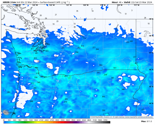
There is potential that heavy showers and potential thunderstorms could continue across the region on Saturday. Below is the HRRR forecast showing instability in the atmosphere (known as CAPE) on Saturday afternoon.
This forecast shows CAPE values of 200-500 across most of the central and southern parts of Washington, with northern Oregon also having decent instability potential.
Finally, let's take a look at how much rain the rounds of moderate to heavy showers could produce, as seen in the HRRR high-resolution forecast for rain through late Saturday.
This forecast shows 0.35-0.5" for most of the lowlands, except 0.5-1" from Olympia to Tacoma and 0.5-0.75" for Whatcom and Skagit Counties. The coastal areas get 0.5-0.9" in this forecast, with 0.1-0.5" in Eastern Washington (most near Spokane).
Be aware for potential heavy showers and a slight chance of thunderstorms from Friday evening through Saturday!


No comments:
Post a Comment