FastCast—Tuesday, March 26 to Saturday, March 30:
A storm moving into the region on Wednesday will bring widespread rain, mountain snow, and some breezier conditions to the Pacific Northwest, followed by what is looking to be a partly to mostly sunny Easter weekend. Tuesday will be on the cloudy side in the morning, with some clearing in the afternoon. Wednesday will be overcast with rain at times throughout the day, and Thursday will be mostly cloudy with a chance of showers (and a slight chance of thunderstorms). Expect the most rain to fall on Wednesday, with totals by late Thursday in the lowlands reaching 0.5-1”. Highs from Tuesday to Thursday will be in the low to mid 50s, with lows in the upper 30s to low 40s. Mountain areas above 3,000 feet have a chance to see up to 10-14” of snow by Thursday, with Snoqualmie Pass receiving less. By Friday, conditions will become partly to mostly sunny, continuing that way into the weekend. Highs on Friday and Saturday will be in the upper 50s to low 60s, with lows in the mid 30s (outlying areas) to low 40s.
———————————————————————
Continue reading the full blog below!
A wet couple days are ahead before a sunnier and somewhat warmer Easter weekend. Let’s take a look at the forecast!
Let’s start with the European model forecast for total rain through Thursday. Most rain will fall on Wednesday, with a chance of showers lingering into Thursday.
This forecast shows the lowlands receiving 0.8-1.5” of rain, with 1.5-3” on the coast and 0.2-0.6” in Eastern Washington.
Let’s compare this to the higher resolution NWS NBM forecast, seen below, also showing total rain through Thursday.
This forecast is a bit drier for the lowlands, showing 0.5-0.8” of rain in total, with 1.5-2.5” on the coast, and 0.1-0.4” in Eastern Washington.
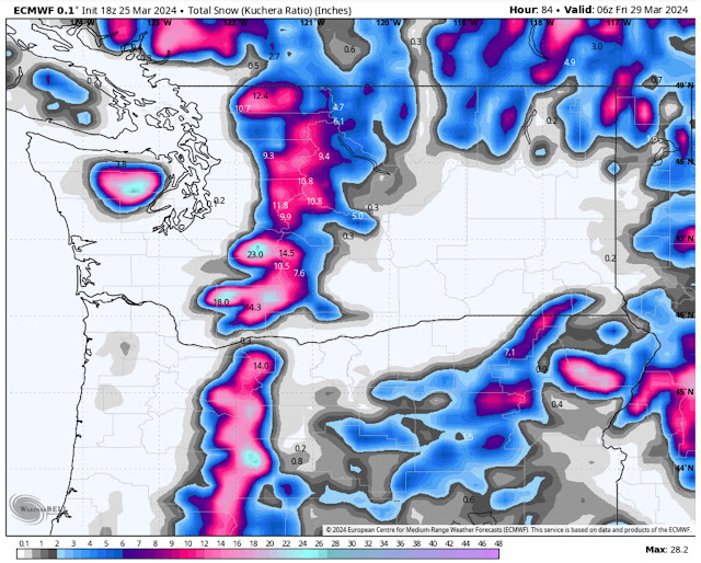
Now, let’s take a look at mountain snow. Snow levels will remain right around 3,000 feet with this storm, so areas like Snoqualmie Pass will likely receive mostly rain/snow mix, with some periods of snow. Higher passes, like Stevens and White, will remain all snow.
Below is the European model forecast for total snow through Thursday.
This forecast shows Stevens and White Passes (along with areas such as Paradise, Crystal Mountain, and Mount Baker) getting 10-14” of snow through Thursday. Most of this snow will fall on Wednesday. Due to the snow level, Snoqualmie Pass will likely only receive 2-4”, though sustained heavier precipitation could lead to higher snow amounts. Regardless, travel through the mountains with care on Wednesday.
One more potential with this storm is a chance of thunderstorms on Thursday. Below is the European model lightning forecast for Thursday afternoon.
This forecast shows a chance of thunderstorms across almost all of Eastern Washington (best chances) and in Western Washington, from Olympia northward. Again, this is a slight chance, but remember that any shower on Thursday, especially in the afternoon, has a chance of being a thunderstorm.
Now, let’s switch gears and take a look at the extended forecast for Easter weekend. Below is the European Ensemble forecast, showing the upper air pattern on Sunday.
Notice the (red) high pressure ridge over British Columbia…that is what will bring a somewhat warmer and sunnier Easter to the Northwest. If this ridge was further south, it could bring a warm stretch like we saw in mid-March. This shows how important the placement of a ridge is.
What kind of “warmth” are we talking about here? Below is the NWS NBM forecast for highs on Easter Sunday.
This forecast shows lowland highs in the low 60s, with Eastern Washington reaching the mid 60s. This would be a beautiful Easter Sunday, so stay tuned for more information on this potential warmup and the potential for warmer conditions by next Monday.


I will look forward to Friday and a nice Easter day on Sunday.
ReplyDelete