Tuesday, April 30, 2024

Mostly Dry to Begin May, Rainy Weekend Likely

 FastCast--Wednesday, May 1 to Sunday, May 5:

After a few days of showers, a relatively dry remainder of the work week is expected. Partly sunny conditions are expected on Wednesday, with highs reaching the upper 50s to low 60s. Thursday will be the best day of the week, with mostly sunny skies and highs in the mid 60s across the region. Clouds will return on Friday, but highs will remain in the mid to upper 60s. However, rain will move in by late Friday evening, continuing at times through late Sunday. Precipitation totals look to be on the heavier side for this round of rain, with amounts of 0.5-1.5" possible, depending on which forecast we look at. Temperatures on the weekend will decrease to the mid 50s, with lows from Friday to Sunday in the mid 40s. Notably, lows on Wednesday and Thursday will be in the mid to upper 30s, with a slight chance for frost in some outlying areas on Wednesday morning. Stay tuned over the next few days for more information about the weekend forecast.

----------------------------------------------------------------------------

Continue reading the full blog below!

A couple nicer days are ahead across Washington, following a few days of showers. Let's take a look at the forecast, and a look ahead to a potentially wetter weekend.

Below is the forecast for morning lows on Wednesday from the NWS NBM model.


Expect morning lows in the mid to upper 30s outside the metro area, with the cities remaining in the upper 30s to low 40s. Eastern Washington will drop to the low to mid 30s. Any areas below approximately 35-36° have a potential for frost, so be aware of this possibility.

Highs on Wednesday will be an increase from Tuesday, as seen below in the NWS NBM forecast.


On Wednesday, expect lowland highs in the upper 50s to low 60s, coastal highs in the mid 50s, Willamette Valley highs in the upper 50s, and Eastern Washington highs in the upper 50s near Spokane and Ellensburg to the mid to upper 60s in the Columbia Basin.

Next, let's take a look at highs on Thursday, which will be the sunniest day in Western Washington, albeit not the warmest. The NWS NBM forecast is below.


On Thursday, the lowlands will reach the low to mid 60s, with the Willamette Valley and coast reaching the upper 50s to low 60s. Eastern Washington will reach the low 60s near Spokane to upper 60s in the Columbia Basin.

Friday will be the warmest day for awhile, but Western Washington's skies will be mostly cloudy as our wet weekend system moves in. Below is the NWS NBM forecast.


Expect highs on Friday to reach the mid to upper 60s in the lowlands, with the coast reaching the upper 50s, the Willamette Valley reaching the upper 50s to mid 60s, and Eastern Washington reaching the mid 60s to mid 70s.

Quite a wet weekend is possible, especially on the European model forecast. We'll look into the weekend forecast more over the next few days, but below is the forecast for total rain in the 48-hour period from Friday evening to Sunday evening.


This forecast shows heavy rain totals of 1-1.5" from Seattle southward through the Willamette Valley, with 0.3-0.9” from Seattle northward. This forecast doesn’t necessarily encompass rain totals for the whole region over the entire weekend, so stay tuned for more information over the next few days!

Sunday, April 28, 2024

Lowland Showers & Mountain Snow to End April

 FastCast--Monday, April 29 to Friday, May 3:

Showers will continue on Monday and the first half of Tuesday across Western Washington. Generally, expect 0.3-0.6" of additional rain, most under Convergence Zone bands and from Olympia south. Some areas may get over 0.6" of rain through Tuesday. There is also a region-wide chance of thunderstorms on Monday and Tuesday, specifically in the afternoons. Remember that any showers have the potential to produce thunder, lightning, and gusty winds. Be prepared if you are outside. Snow levels in the mountains will decrease to 2,000-2,500 feet on Monday and Tuesday. Expect higher passes like Stevens and White to receive up to 8" of snow, with Snoqualmie Pass picking up 2-4". Some winter driving conditions are possible, so don't be caught off-guard by late April snow! Regarding lowland temperatures, Monday and Tuesday will be on the chilly side for April, with highs in the low to mid 50s both days. Wednesday will be mostly sunny, with highs increasing to the upper 50s to low 60s. Clouds and showers will return on Thursday, but temperatures will remain in the upper 50s to low 60s. Friday will be the nicest day of the week, with mostly sunny skies and highs likely in the mid to upper 60s! Expect overnight lows to generally be in the upper 30s to mid 40s, coldest on Monday and Wednesday mornings.

------------------------------------------------------------------

Continue reading the full blog below!
More showers are expected on Monday and Tuesday, along with a region-wide chance of thunderstorms. Additionally, snow levels will be down to 2,000-2,500 feet on Monday and Tuesday, bringing a chance of late April snow at the passes.

Let's start with the snow forecast. Below is the NWS NBM high-resolution snow forecast through Tuesday evening.


This forecast shows the higher passes (Stevens & White) getting 6-10" of snow, with Snoqualmie Pass getting up to 3-5", Paradise and Crystal Mountain getting 6-10", and Mount Baker and the North Cascades Highway getting 4-5". This event shows that mountain snow is still possible at the passes into April. Be prepared for potential winter driving conditions over the passes, especially on Monday.

Now...back to the lowlands. Let's take a look at expected rain through Tuesday night. Most showers will be on Monday, with showers decreasing in coverage on Tuesday. Below is the European model forecast for rain through Tuesday night.


Generally, expect an additional 0.3-0.5" of rain across the lowlands. However, with the showery nature of the incoming precipitation, totals will likely be a bit more scattered. This forecast shows areas of higher rain totals between Tacoma and Mount Vernon, due to Convergence Zone bands (0.5-0.9"), and areas south of Olympia getting 0.6-0.8". The coast gets 0.5-1.5" through Tuesday, with parts of Eastern WA near the Cascades and near the Idaho border getting 0.2-0.4". 

Let's compare this with a higher-resolution forecast, which will show the potential areas of heavier precipitation due to showers and thunderstorms. Below is the NAM high-resolution forecast for total rain through Tuesday night.


This forecast shows areas of showers producing paths of increased precipitation, on both sides of the Cascades. Overall, the lowlands receive at least 0.25" of rain, with areas of heavier showers getting up to 0.8", with isolated higher totals, especially in Convergence Zone bands and on the coast.

The cause of these strong showers that could bring high rainfall totals is a region-wide chance of thunderstorms, on Monday and Tuesday, but with the higher chance being on Monday. Below is the NAM high-resolution forecast for CAPE (instability in the atmosphere) on Monday afternoon.


This forecast shows CAPE values of 200-500 across Washington on Monday afternoon. While these values would be considered quite low in the Midwest, they're at least respectable for Washington.

Another way of looking at thunderstorm potential is lightning flash density, essentially the chance of lightning at a given spot over a certain time period. In this case, we're looking at 3-hour lightning flash density on Monday afternoon, forecasted from the European model.


This forecast shows a lightning potential for most of the lowlands, with the highest potential in Eastern Washington, especially around the Tri-Cities, Walla Walla, and the Eastern Columbia River Gorge. The thunderstorm chance in Western Washington is going to be highest around the Convergence Zone, so likely somewhere between Seattle and Skagit County.

Any strong showers or thunderstorms that do develop will bring heavy rain, gusty winds, a potential for small hail, and of course, a chance of thunder and lightning. Visibility will likely decrease while driving, and areas of standing water are possible too.

There's a good amount of weather going on through Tuesday, with mountain snow, lowland showers, and a statewide chance of thunderstorms! Be prepared out there!

Wednesday, April 24, 2024

Wet Weather Returns to Western Washington

 FastCast--Thursday, April 25 to Monday, April 29:

After a relatively dry month, by Seattle standards, a rainy pattern will return to Western Washington to round out April. Thursday will be the rainiest day of the pattern, with 0.4-0.8" of rain across the lowlands. A chance of showers will persist every day through at least Monday, and likely beyond. Conditions will be overcast, except for some potential sunbreaks on Monday. High temperatures will be below average, with highs on Thursday only reaching the low to mid 50s, and remaining in the mid to upper 50s through Monday. Wetter and cloudier conditions will keep lows in the upper 40s through Sunday, decreasing to the upper 30s to low 40s by Monday. Despite a wetter pattern, snow will remain mostly above 5,000 feet, with a trace to 1" of snow possible at the higher passes through early next week.

--------------------------------------------------------------

Continue reading the full blog below!

A wet pattern is returning to Western Washington after a relatively dry past few weeks. Let's take a look at the forecast!

We'll start with the European model forecast for rain through midday Friday.


This forecast shows areas from Seattle south and Mount Vernon north getting 0.5-0.8" of rain by midday Friday, with a rain shadow from Seattle to Mount Vernon, and west along the Strait, where 0.3-0.5" of rain is possible. The coast and mountains will receive 1-2" of rain, most in the Olympic Mountains. Parts of Eastern Washington, mainly mountainous areas, will get 0.1-0.3" of rain.

Let's compare this forecast to the high-resolution NWS NBM forecast, also showing total rain through midday Friday.


This forecast largely agrees with the European model, except it shows a lesser rain shadow, which is mainly confined to areas west of Whidbey Island. This forecast shows 0.5-0.9" of rain in the lowlands, with 1-2" on the coast, and up to 3.75" in the mountains, most in the Olympics and Southern Cascades.

What about mountain snow? Below is the European model forecast for total snow through midday Friday.


As we get later in spring, it gets harder to get significant snowfall. The winners for snow will be the volcanic peaks, with Paradise and Mount Baker being the only recreation areas to get some snow, as the snow level remains around 5,000 feet.

You'll definitely notice that temperatures will be on the cooler side, as seen below in the NWS NBM forecast for Thursday's highs.


This forecast shows highs on Thursday only reaching the low to mid 50s west of the Cascades. Eastern Washington will reach the low to mid 60s. Expect temperatures across the state to warm a few degrees on Friday.

We'll end this blog by taking a look at the extended outlooks for the end of April and first few days of May. These outlooks are from the NWS Climate Prediction Center (CPC)

First, the CPC temperature outlook.


For April 30-May 4, this outlook shows a 50-70% probability of below-average temperatures in Washington, highest for Western Washington.

Next, let's see how the temperature and precipitation outlooks correlate.


This outlook shows a 40-50% probability of above-average precipitation for Washington through the first week of May. 

Stay tuned for more information, and enjoy the rainy weather while we have it! All the rain counts toward more water for the summer!


Monday, April 22, 2024

Warm Tuesday, Wetter & Cooler Pattern Ahead

FastCast--Tuesday, April 23 to Friday, April 26:

A warm day is ahead on Tuesday, with highs in the lowlands reaching the upper 60s to low 70s, under partly to mostly sunny skies. However, a major pattern change is ahead, with a shift to cooler and wetter conditions. Highs will drop to the upper 50s to low 60s by Wednesday, with overcast skies. Rain will move in on Thursday, continuing at times through Friday. Through late Friday, most of the lowlands will receive 0.4-0.8" of rain. High temperatures will also be on the cool side, only in the low to mid 50s. Expect lows in the low to mid 40s. (Check the bottom of the blog for a list of peak winds from the stronger-than-expected Saturday storm).

To see some video of the gusty winds and a timelapse of the Saturday storm, check out my YouTube channel by clicking the YouTube logo to the right!

-----------------------------------------------------------------------

Continue reading the full blog below!

For the last time in awhile, the lowlands will have a warm and pleasant day, with highs likely reaching into the 70s. However, big changes are ahead, with a pattern change likely. Let's take a look at the forecast!

Let's start with the NWS NBM high-resolution forecast for high temperatures on Tuesday.


Tuesday will be warm and pleasant across Washington. Expect lowland highs to reach the upper 60s to low 70s, except in the mid 60s from Everett northward. The coast will reach the upper 50s to low 60s, the Willamette Valley will warm into the low to mid 70s, and Eastern Washington will reach the mid 60s to low 70s.

Temperatures will begin to cool down on Wednesday. Below is the NWS NBM forecast for highs on Wednesday.


Lowland highs will drop to the upper 50s to low 60s on Wednesday, with the coast dropping to the mid 50s and the Willamette Valley dropping to the mid 60s. Eastern Washington will warm into the mid 60s to mid 70s, getting warmer instead of cooling down as the high pressure ridge moves eastward.

Temperatures will cool further by Thursday, as seen in the NWS NBM forecast.


Highs across Western Washington and Oregon will drop to the low to mid 50s. Eastern Washington will drop to the low to mid 60s, except the upper 60s around the Tri-Cities. 

As the temperatures cool across the region, weather systems will begin to move in. A system will spread rain across Western Washington on Thursday, with showers continuing on Friday, and likely into the weekend. The European model forecast below shows total rain through Friday night.


This forecast shows the lowlands getting 0.5-0.8" of rain, except some areas north and east of the Olympics will get less rain in a rain shadow. Areas from Olympia south will receive 0.8-1.3", and the coast will get 1.3-1.6". Even Eastern Washington will get in on the rain, with 0.1-0.3" for most of the region. The mountains of NE Washington will get up to 1" of rain.

So...what's the cause of this pattern change? Take a look at the European model forecast below, showing the high and low pressure systems at around 18,000 feet late Thursday.


This shows a broad area of troughing over the Pacific Northwest by Thursday. Troughing will likely continue across the Northwest through the end of April...so stay tuned!

------------------------------------------------------------

Saturday Peak Winds:

NAS Whidbey: 49 mph

Shelton: 46 mph

Port of Tacoma: 44 mph

Bremerton: 43 mph

Camano Island: 42 mph

Lake Stevens: 40 mph

Tacoma Narrows: 39 mph

Boeing Field: 38 mph

Sea-Tac Airport: 37 mph

These winds caused over 22,000 PSE customers to lose power, with over 10,000 customers losing power in the Seattle City Light and Snohomish PUD service areas as well.


Thursday, April 18, 2024

Rapid Saturday Evening Cooldown to End Warm Stretch

FastCast--Friday, April 19 to Tuesday, April 23:

Friday will be a warm and beautiful day across Western Washington. Highs will likely reach the upper 60s to low 70s, with easterly gap winds bringing warming and gusts of 30-40 mph for the foothills. High clouds will move in on Saturday, with highs reaching the upper 60s to low 70s by mid-afternoon. Then, a strong marine push combined with an incoming cold front will bring a rapid cooldown, with temperatures dropping 15-20° within 3 hours by early evening. Winds will briefly gust 30-40 mph across the region, and showers will move through. A Convergence Zone setting up between Northern King and Skagit Counties will bring a chance of thunderstorms north of Everett on Saturday night. By Sunday, conditions will be partly cloudy, with highs in the mid 50s to low 60s. Monday will be partly cloudy, with highs increasing to the upper 50s to low 60s, followed by mostly cloudy skies and highs increasing further to the mid to upper 60s on Tuesday. Overnight lows through Tuesday will be in the low to mid 40s. By the middle of next week, we'll likely start to cool down again.

---------------------------------------------------------

Continue reading the full blog below!

A warm and pleasant day is expected on Friday, followed by another warm day on Saturday, with a marine push/cold front combination on Saturday evening bringing a major cooldown, gusty winds, and showers. Let's take a look at the forecast!

We'll start with the NWS NBM model high-resolution forecast for highs on Friday.


Expect highs in the lowlands to reach the upper 60s to low 70s, with some areas in the North Sound remaining in the mid 60s. The coast will reach the mid to upper 60s, the Willamette Valley will reach the low to mid 70s, and Eastern Washington will reach the mid 50s to low 60s in the north and mid to upper 60s in the south.

Part of the reason that the lowlands will be much warmer than Thursday will be the presence of easterly gap winds (known as "Cascadia" winds). The NAM high-resolution forecast below shows the expected wind gusts through early Saturday.


Notice gap winds gusting 30-35 mph for parts of the lowlands, roughly from Federal Way to Seattle, with areas such as North Bend and Enumclaw reaching 35-40 mph. Also notice that the Portland metro area will have easterly gusts of 35-45 mph, strongest near the Gorge.

Now, let's take a look at Saturday's highs, also from the NWS NBM model.


Saturday will be warmer for most of the region, despite there being near 100% cloud cover due to high clouds. Expect the lowlands to reach the mid 60s to low 70s, with the coast only reaching the low 60s, the Willamette Valley also reaching the mid 60s to low 70s, and Eastern Washington reaching the mid 60s to low 70s.

However, this forecast is somewhat deceptive. Saturday's highs will occur around 2-3 PM, earlier than typical highs. Below is the NAM forecast for temperatures at 2 PM Saturday.


At 2 PM, the lowlands are in the upper 60s to low 70s. However, notice that the coast has dropped to the low 50s. Highs on the coast will occur around midday.

Around 2 PM, a marine push/cold front will be located between the coast and the lowlands, moving quickly eastward. To see this, let's take a look at temperatures by 5 PM Saturday.


By 5 PM, the marine push/cold front will have hit the lowlands, with temperatures dropping rapidly, all the way down to the low 50s in Olympia, the mid 50s to low 60s along the I-5 corridor. Notice how the foothills are still in the mid 60s at 5 PM.

However, by 8 PM (seen below), the marine push/cold front will have advanced through the entirety of Western Washington, bringing much cooler temperatures in its wake.


By 8 PM, all of Western Washington has dropped to the mid 40s to low 50s, with Eastern Washington cooling rapidly into the low 50s to low 60s.

A great visualization of the rapid temperature decrease is found on this map below, showing the NAM model forecast for temperature change from 3 PM to 6 PM Saturday.


This shows that as the marine push/cold front moves across Western Washington, temperatures will drop 15-20° within 3 hours. This temperature drop will occur across the entire region as this feature moves through.

Another impact of this feature will be a brief shot of wind through the region. In addition to strong westerly winds through the Kittitas Valley and some gusty winds across parts of Eastern Washington, gusty southwest winds will move through the lowlands on Saturday evening. Below is the NAM high-resolution forecast showing gusts at 6 PM.


Around 6 PM Saturday, as the marine push/cold front moves through the lowlands, expect winds to increase, with brief gusts of 30-35 mph, with some areas gusting up to 40 mph, especially near the water and in the San Juan Islands.

One final weather impact to be aware of with this feature is that in addition to bringing a brief round of showers from late Saturday afternoon through the evening, a Convergence Zone band between Northern King and Skagit Counties will bring a slight chance of thunderstorms late Saturday night. Below is the European model lightning forecast for Saturday night.


This forecast shows lightning potential over Island, Skagit, and Snohomish Counties. This outlines the potential for thunderstorms in this Convergence Zone band. There is also a very low, but non-zero chance for isolated thunderstorms along the main marine push/cold front as it moves across the lowlands on Saturday evening.

Stay tuned for more information via Twitter and Pacific Northwest Weather Watch YouTube (link on right side of blog) about this dynamic feature on Saturday, and enjoy the sun & warmth while it lasts!

Tuesday, April 16, 2024

Chilly Start to Wednesday, Warmup Ahead

 FastCast--Wednesday, April 17 to Sunday, April 21:

After a couple showery and cooler days on Monday and Tuesday, a warmup and transition to mostly sunny conditions is expected through Friday. Wednesday morning will be quite chilly across the region, with lows in the low to mid 30s in the lowlands. Afternoon highs will reach the mid 50s in the north to the upper 50s to low 60s in the south. Lows on Thursday morning will reach the upper 30s, followed by highs region-wide reaching the low to mid 60s. Friday will be the nicest day of this stretch, with highs reaching the upper 60s across the region, with sunny skies. Clouds and a chance of showers return on Saturday, with highs likely dropping back to the upper 50s to low 60s. Sunday looks to be partly cloudy, with highs again in the upper 50s to low 60s. Expect morning lows from Friday to Sunday to be in the low to mid 40s.

------------------------------------------------------------------

Continue reading the full blog below!

Cooler and showery weather will soon be replaced by a few days of sunshine, with temperatures warming each day through Friday. However, before we get there, we will have a chilly morning, with frost possible across some parts of the region. Let's take a look at the forecast!

Below is the NWS NBM model forecast for low temperatures on Wednesday morning.


Expect lows in the lowlands to reach the low to mid 30s, likely coldest from Tacoma southward. Eastern Washington will also have lows in the low to mid 30s, coldest in the Palouse and near the Cascades. Any frost that forms at this time of year can damage sensitive plants. If you have sensitive plants, be sure to move them inside for Wednesday morning's lows, and for Thursday morning's lows in Eastern Washington.

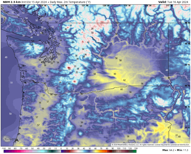
Under mostly sunny skies, Wednesday will be warmer than Tuesday was, as seen below on the NWS NBM forecast.


Expect highs across Western Washington to reach the upper 50s to low 60s, with some areas remaining in the mid 50s. The Willamette Valley will reach the low to mid 60s, while Eastern Washington will reach the mid 50s around Spkane and the Palouse and the low to mid 60s in the Columbia Basin.

Further warming is expected on Thursday, as seen in the NWS NBM forecast below.


On Thursday, expect highs in Western Washington to reach the low to mid 60s, with the Willamette Valley reaching the upper 60s to low 70s. Eastern Washington will be a bit slower to warm up, with highs in the mid 50s around Spokane and the mid 60s in the Columbia Basin.

Finally, let's take a look at highs on Friday, which will be the warmest day of the week.


Friday will be quite nice across Western Washington, with highs reaching the mid to upper 60s (possibly the low 70s in the metro areas). The Willamette Valley will reach the low to mid 70s, while Eastern Washington warms up to the mid 50s to upper 60s.

The best thing about Wednesday, Thursday, and Friday is that skies will be almost 100% clear, save for some areas of morning clouds, especially along the coast. What is causing these clear skies and warmer days? Take a look at the European model forecast below.


Notice a large ridge of high pressure over Alaska and Northwestern Canada, with troughing over the Midwest US, and a subtle ridge over the Northwest. That ridge, in combination with the larger-scale pattern, is bringing our brief warm spell.

Stay tuned for more information about the weekend forecast and what's ahead next week!

Sunday, April 14, 2024

Early Week Cooldown Followed by Midweek Rebound

 FastCast--Monday, April 15 to Friday, April 19:

Sunday was warm and beautiful across much of Washington state, with lowland highs reaching the mid to upper 60s! However, significant changes are ahead, with a large cooldown on Monday and Tuesday. Breezy westerly winds will gust up to 40-45 mph along the Strait and in Island County through midday Monday, with gusts of 20-30 mph possible around the lowlands through Monday evening. Monday will be mostly cloudy, with lowland highs in the low to mid 50s. Highs on Tuesday will be relatively similar, but clouds will decrease throughout the day. Temperatures rebound on Wednesday, with lowland highs increasing to the upper 50s to low 60s. Of note is that Wednesday morning lows will likely drop to the low to mid 30s across the lowlands, meaning that localized frost is possible. Be aware of this if you have sensitive plants. Highs will increase to the mid to upper 60s on Thursday and Friday. Expect conditions to be mostly sunny from Wednesday to Friday!

-----------------------------------------------------------------------------------

Continue reading the full blog below!

After a beautiful weekend, a cooldown is in store across the state to begin the work week.

Let's start with the forecasted temperature change from Sunday afternoon to Monday afternoon, seen below in the European model forecast.


Almost the entire state will see a 10-20° drop in temperatures on Monday compared to Sunday. The coast will see a lesser drop since marine air had already moved in earlier on Sunday. 

This temperature decrease is being driven by gusty westerly winds, that increased late Sunday evening, and will continue at times through Monday. Let's take a look at the NAM high-resolution forecast, showing peak wind gusts through Monday.


This forecast shows westerly winds along the Strait of Juan de Fuca and in Island County gusting 40-45 mph, strongest on Northern Whidbey Island and near Port Angeles. The coast and lowlands will gust 20-30 mph at most. Eastern Washington is a different story, with most areas near the eastern slopes of the Cascades gusting 40-50 mph, strongest in wind-prone gaps such as the Kittitas Valley, and in wide, flat areas downwind of gaps, such as the Waterville Plateau. The Palouse region and areas east of the Columbia River Gorge will also see gusts of 35-40 mph.

These winds will usher in cooler temperatures across the entire region. Below is the NWS NBM high-resolution forecast for highs on Monday.


Expect lowland and coastal highs to drop to the low to mid 50s, warmest from Tacoma to Olympia. The Willamette Valley will drop to the upper 50s. Eastern Washington has one more warm day, with highs remaining in the low to mid 60s, except in the upper 60s in the lower Columbia Basin.

By Tuesday, most of the state will be on the cooler side, as seen below.


The coast and lowlands will again be in the low to mid 50s, with the Willamette Valley in the mid to upper 50s. Eastern Washington will cool dramatically, with highs only in the low 50s near Spokane to the low 60s in the Tri Cities.

Conditions will begin to get warmer by Wednesday, but before we get there, we'll have a chilly morning, with some frost possible. Below is the NWS NBM forecast for Wednesday morning's lows.


On Wednesday morning, lows will drop to the low to mid 30s in Western Washington and the Willamette Valley, and will also drop to the low to mid 30s in Eastern Washington. This means that some frost is possible across the state. This is a threat to sensitive plants, so be aware of this frost possibility on Wednesday morning.

Finally, here's a look at highs on Wednesday, as temperatures begin to rebound across the state. 


Highs in the lowlands and along the coast will increase to the upper 50s to low 60s under mostly sunny skies. The Willamette Valley will warm into the mid 60s, with Eastern Washington increasing to the mid 50s around Spokane and the low to mid 60s in the Columbia Basin.

Stay tuned for more information on what looks to be a warm and sunny end to the week!

Wednesday, April 10, 2024

Weak System Ahead, Nice Weekend Likely, and a Look at Snowpack

FastCast--Thursday, April 11 to Monday, April 15:

A weak system will move through from Thursday to midday Friday, bringing cooler, cloudier conditions and light showers to Western Washington. The lowlands can expect to see 0.05-0.10" of rain with this system, with more rain on the coast and in the Northwest Interior. Highs on Thursday and Friday will be in the mid 50s, with some areas reaching the upper 50s on Friday as clouds clear out in the afternoon. A short-lived ridge will build over the region from late Friday through Sunday. Saturday will be an excellent day, with mostly sunny skies and highs in the low to mid 60s, warmest Seattle southward. Sunday will be a bit cloudier and cooler, with highs in the upper 50s to low 60s. As another system moves in late Sunday into Monday, it'll likely be breezy across the region, especially along the Strait of Juan de Fuca. Stay tuned for more information on this in my Friday blog. The arriving system will bring a drop in temperatures, an increase in clouds, and a chance of showers on Monday, with highs dropping to the low to mid 50s. 

---------------------------------------------------------------------

Continue reading the full blog below!

A relatively weak system will impact Western Washington on Thursday and early Friday, bringing a light round of rain to the region. The second half of Friday will bring decreasing clouds, followed by a pleasant weekend (especially Saturday).

Let's start by taking a look at the European model forecast for rain through Friday, seen below.


The lowlands will only see around 0.05-0.1" of rain with this system, with areas from Mount Vernon northward getting 0.15-0.3", and the coast getting 0.3-0.4", except 0.6-0.9" from Ocean Shores northward. Eastern Washington will remain mostly dry, except for the far northern Cascades and the areas surrounding the Blue Mountains, which will get 0.1-0.3" of rain, with isolated higher totals possible.

Next, let's take a look at the snow forecast through Friday, also from the European model.


We are getting to the point in the year where a system has to pack much more of a punch to produce much snow for the Cascades. In winter, weak systems like this can bring a few inches of snow to most of the mountains, but in spring, a weak system struggles to bring more than 3-5" to the highest terrain. The Olympics and North Cascades will be the only areas to get more than 1" of snow with this weak system.

Speaking of snow, it's a good time to take a brief look at the current snowpack situation, seen on the USDA/NWCC Snowpack Interactive Map for Washington.


This is a classic signature of an El Niño winter in the Pacific Northwest. Most of Washington's snowpack in the Cascades is 60-70% of normal, with only the southern and extreme eastern parts of the state having snowpack of 70-90%. As of this time, reservoir storage on both sides of the Cascades is still near or slightly above normal.

Now, let's shift to taking a look at the nicer weekend forecast. Below is the European Ensemble forecast, showing the upper-level pattern influencing our nice weekend.


Notice the high pressure ridge over Washington. While it'll be relatively short-lived (late Friday through Sunday), it will at least bring a pleasant spring weekend!

Saturday will definitely be the best day of the weekend, as seen in the high temperature forecast below from the NWS NBM high-resolution model.


On Saturday, expect lowland highs in the low to mid 60s, with the coast reaching the upper 50s to low 60s, and the Willamette Valley reaching the mid 60s to low 70s. Eastern Washington will be very nice, with highs in the upper 60s near Spokane to the upper 70s (potentially low 80s) in the Columbia Basin.

I'm looking forward to a nice weekend! Stay tuned for an update on our return to cooler weather (again) for the first half of next week.

Sunday, April 7, 2024

No Eclipse View for Western WA, Unsettled Weather Continues

FastCast--Monday, April 8 to Friday, April 12:

While most of the US will be able to see at least a very partial solar eclipse on Monday, the same cannot be said for Western Washington, where near 100% cloud cover will make it so the ~20% eclipse will be obscured. In the absence of the eclipse, expect showers and breezy conditions from Monday to Tuesday, with 0.2-0.6" of rain across the region. Winds will gust 20-30 mph, except up to 40-45 mph along Admiralty Inlet, in the San Juans, and in Western Whatcom County. We'll dry out on Wednesday, with another chance of showers on Thursday, followed by a drier Friday. This week, expect lowland highs in the mid 50s to low 60s, except only in the low 50s on Monday. The warmest day of the week will likely be Wednesday.

------------------------------------------------------------------

Continue reading the full blog below!

While Western Washington will be far removed from the total solar eclipse occurring across the Central and Eastern US on Monday, there will still be 20-30% totality across the state from 11 AM-12 PM. However, this will not be easily seen west of the Cascades. 

Below is the NWS NBM forecast for cloud cover around midday Monday.


Expect 85-100% cloud cover west of the Cascades. In Eastern Washington, cloud cover will be 10-60%, most (40-60%) along the eastern slopes of the Cascades and near Spokane. The Columbia Basin will see 10-30% cloud cover, least around the Tri-Cities and Walla Walla. 

The lack of eclipse viewing in Western Washington will be due to a system moving in that will bring rain and mountain snow from Monday to Tuesday. Below is the European model forecast for total rain through Tuesday night.


This forecast shows 0.4-0.6" across the lowlands, except 0.2-0.3" in a rain shadow around areas from Seattle to Everett. The coast and Kitsap Peninsula will receive 0.9-1.9", most on the northern coast. The eastern slopes of the Cascades and the eastern third of Eastern WA will receive 0.05-0.15" with this system.

Next, let's take a look at the NWS NBM model forecast for mountain snow through Tuesday night.


This forecast shows a potential for 2-4" of snow at Stevens Pass, with lower amounts of a trace to 1" possible at Snoqualmie and White Passes. Higher recreation areas like Paradise and ski areas at Mount Baker, Mission Ridge and Crystal Mountain will likely receive up to 5-8" of new snow with this system.

This system will also bring a round of breezy to locally windy conditions across Washington. Below is the European model forecast for wind gusts through Tuesday.


Expect gusts of 25-35 mph around the lowlands, with gusts of 40-45 mph possible for Whidbey & Camano Islands, the San Juans, and Western Whatcom County. Most of the coast and most of Eastern Washington will gust 30-40 mph. 

Lastly, here's a look at the NWS NBM model temperature forecast for Western Washington's warmest day of the week, Wednesday.


This forecast shows lowland highs reaching the upper 50s to low 60s, with highs in the Willamette Valley reaching the mid 60s, and Eastern Washington reaching the low to mid 60s, except into the upper 60s for the lower Columbia Basin.

Overall, relatively benign weather is ahead for the next few days, so enjoy the lull in activity around the Northwest!

Next Storm System Hits Western Washington

  8-26 Video Briefing: Next Storm System Hits Western Washington