No FastCast today. Continue reading the full blog below. (Ice storm information at bottom)
Extreme cold is expected across Washington state on Thursday, with frigid temperatures and incredibly cold wind chills.
Let’s start with the forecast for low temperatures on Thursday morning. The NAM high resolution forecast is below, and it is likely showing the coldest possible solution.

If this forecast verifies, expect lows in the lowlands in the low to mid teens. Whatcom County will reach the low single digits, the coast will reach the low to mid 20s, and Eastern Washington will reach 20 below to 5 above.
For a bit more moderate of a forecast, below is the European model for Thursday morning lows.

The European model shows the lowlands dropping to the mid teens to low 20s, with some colder spots. Areas from Everett northward drop to the low single digits to the low teens, the coast drops to the low 20s to low 30s, and Eastern Washington drops to 20 below to 5 above (colder in the northern mountains and valleys, potentially as low as 30 below).
These temperatures are hazardous on their own, but due to a strong Arctic high over the Great Plains, there will be a cross-Cascade pressure gradient, causing biting easterly winds across the lowlands.
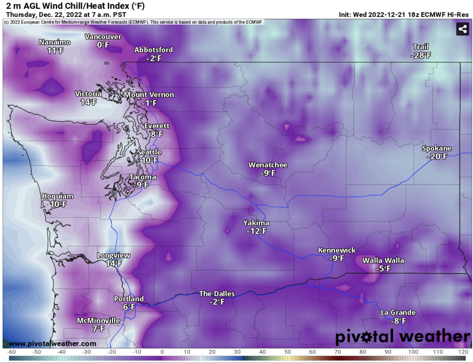
Wind chills will be coldest Thursday morning, around sunrise. Below is the NWS NBM forecast for wind chills at 8 AM Thursday.

Wind chills will be in the low single digits to low teens across Western Washington, except in the foothills and Whatcom County, where wind chills will reach -5 to -15. Incredible wind chills of -5 to -30 are expected for the Cascades and Eastern Washington.
Let’s see if the European model agrees. Below are the European model forecasts for wind chills at 7 AM Thursday.
The European model agrees, showing wind chills in the low single digits to low teens across Western Washington, except 0 to -10 in the foothills and from Mount Vernon northward. The European agrees with the incredible -5 to -35 wind chills in Eastern Washington and the Cascades.
High temperatures on Thursday won’t offer much relief from the cold. Below is the European model forecast for Thursday’s highs.

The European model shows highs in the low to mid 20s in lowlands, and in the low single digits to low teens in Eastern Washington (-5 to 5 in the Cascades).
Let’s compare this to the NAM high-resolution model, showing a colder forecast for Thursday’s highs.

The NAM forecast shows highs only getting into the upper teens to low 20s, with even the coast getting into the mid to upper 20s. Eastern Washington reaches the single digits to mid teens, with the Cascades only reaching -5 to 5.
Wind chills around midday will remain very cold, as seen below in the European model forecast for 1 PM Thursday.

Around midday, the European model forecast shows wind chills remaining in the mid teens to low 20s, except in the single digits in Whatcom County. Eastern Washington and the Cascades will have wind chills in the -15 to +10 all day.
These frigid wind chills all day are caused by the strong pressure gradient across the Cascades, which will bring winds gusting 15-30 mph in the lowlands and potentially 35-50 mph in the Cascade foothills and Whatcom County.
There is potential for a significant ice storm on Friday, with disruptive freezing rain possible. The European model forecast below shows the potential freezing rain accumulation through late Friday.

This could be a significant ice storm for areas from Seattle to Portland. Substantial uncertainty remains, so stay tuned and prepare for potential impacts. I will have an update by tomorrow night.

No comments:
Post a Comment