A modified arctic front is moving south through British Columbia and will impact Western Washington from Sunday to Monday. The biggest impacts will be a dusting to 3 inches of snow and a noticeable decrease in temperatures area-wide.
Let’s take a look at what everyone wants to know: the snow forecasts. The best way to get a consensus of what will happen is to compare multiple forecast models.
The first chance of snow will be from Sunday morning to Monday morning, with precipitation starting in the north and moving south through the evening.
We will start with the European model, known to be accurate. All forecasts will show snow through 10 AM Monday (note: 0.1-0.4 more inches could fall after this).
The European model shows 0.2-3 inches of snow across the lowlands. The European model shows the most in a Convergence Zone from Seattle eastward, and 0.5-2 inches from Seattle north, with less snow (trace to 0.5”) from Seattle south.
Now, the NAM model high-resolution forecast through 10 AM Monday.
The NAM shows 0.25-2 inches of snow area-wide, (including the coast) with up to 3-4 inches in Whatcom and Skagit Counties.
Finally, let’s look at the National Weather Service’s NBM model (through 10 AM Monday). This forecast blends multiple models together to get a forecast.
The NWS NBM shows 0.25-1 inch of snow for the entire region (including the coast), with up to 2 inches in the foothills.
In all forecasts, the mountains receive 6-12 inches of snow.
This modified arctic front will bring a noticeable decrease in temperatures from north to south, generally from Sunday morning to late Sunday night.
Below is the European model forecast for low temperatures overnight Sunday into Monday morning.
Expect lows in the lowlands to be in the mid 20s to near 30º, except frigid in the mid teens to low 20s in Whatcom and Skagit Counties. Eastern Washington will be getting colder, with lows in the single digits to low teens, except in the low to mid 20s in the lower Columbia Basin.
Monday won’t be very warm, with temperatures likely remaining below freezing for most areas of the state, as seen in the NAM model for high temperatures on Monday.
This may be a couple degrees on the cold side, but expect Monday’s highs around the lowlands to be in the upper 20s to low 30s, with even colder highs in the low to mid 20s in Whatcom and Skagit Counties.
Finally, it is important to consider the wind chill. Fraser outflow winds will gust 40-50 mph in Whatcom and San Juan Counties, with 10-20 mph gusts in the remainder of the lowlands. In the NWS NBM forecast below, you can see wind chills early Monday morning.
Expect brutal wind chills in the 5 below to 10 above range for Whatcom and San Juan Counties, with wind chills also in the 10 below to 15 above range for Eastern Washington. The rest of the lowlands will also be very cold, with wind chills in the low to mid 20s. Wind chills will be worst in the mornings, evenings, and overnight.
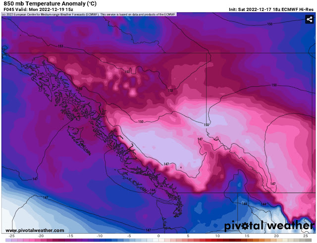
One more quick note…what is the source of all this cold and lowland snow? An arctic high (or an area of high pressure moving south from Northern Canada) has moved into British Columbia, and it is pushing its modified arctic front and associated frigid air into the Pacific Northwest. This can be seen below on the European model, showing temperature anomalies at 5,000 feet early Monday.
Notice the very cold air moving into the Pacific Northwest, and the downright frigid air in Interior BC/Alberta and Montana.
Stay tuned to my blog, Twitter, Pacific Northwest Weather Watch on YouTube, and local news stations for more updates, as this is not the end of the winter weather, with more expected throughout next week.


No comments:
Post a Comment