FastCast—Tuesday, June 13 to Friday, June 16:
A significant change is ahead for Western Washington on Tuesday. Highs reached the upper 70s to mid 80s across the area on Monday, with mostly sunny skies. However, expect a much different scene on Tuesday, with mostly cloudy conditions (with some sun possible in the afternoon). Tuesday’s highs will drop to the mid 60s to low 70s across the lowlands, and the influx of marine air will bring breezy winds gusting 20-35 mph in the lowlands, 30-40 mph along the Strait and on Northern Whidbey Island, and 35-45 mph in Eastern Washington. Winds will peak in the afternoon & evening. Wednesday will bring morning clouds and potential afternoon clearing, with highs in the upper 60s to low 70s, and Thursday will be partly sunny, with highs in the upper 60s to low 70s again. Friday will be mostly cloudy, with highs in the upper 60s and a chance of showers late in the evening. Through the week, expect lows in the upper 40s to low 50s.
———————————————————————
Continue reading the full blog below!
A much cooler day is expected on Tuesday across Western Washington, as the overall pattern trends cooler and closer to average (likely below average by Saturday, which will make for a cool & cloudy Father’s Day/Juneteenth weekend, but more on that in a later blog).
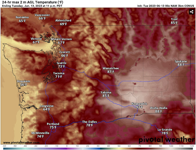
Below is the NAM high-resolution forecast for highs on Tuesday.
Expect highs in the lowlands to be in the mid 60s to low 70s, in the mid 50s on the coast, and in the upper 80s to mid 90s in Eastern Washington.
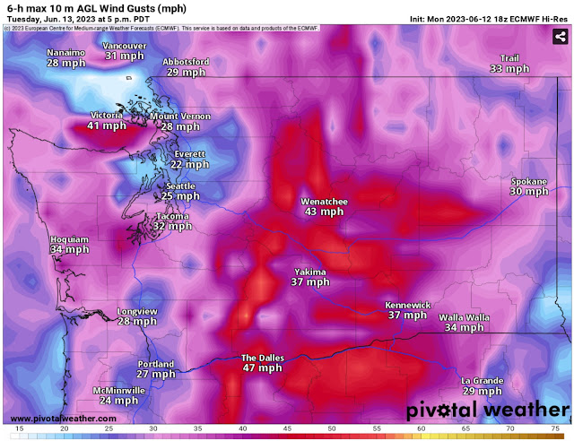
Temperatures will drop steadily through the evening as marine air flows across the entire state. This will be a strong marine push, and will bring gusty winds for most of the region. Below is the European model forecast for wind gusts on Tuesday afternoon.
Expect gusts of 20-35 mph in Western Washington, except 30-40 mph near the Strait and on northern Whidbey Island. Eastern Washington will have stronger winds, with gusts of 35-45 mph (locally higher) in the afternoon and evening.
By 6 PM Tuesday, temperatures across the state will be substantially cooler than 24 hours previous as the strong marine push arrives. Below is the NAM forecast for 24-hour temperature difference at 6 PM Tuesday.
Expect a 10-25º decline in temperatures versus what they were on Monday across the lowlands. Notice that at this time (6 PM), the marine air is moving across Eastern WA, with a line almost down the middle of the region showing where temperatures will be cooler or warmer than 6 PM Monday.
As we continue through the week, temperatures across Washington will stabilize near seasonal averages. Below is the NAM forecast for Wednesday’s highs.
On Wednesday, expect lowland highs in the mid to upper 60s, in the mid to upper 50s on the coast, and in the mid to upper 70s in Eastern Washington.
Thursday will benefit from a brief high pressure ridge that will increase temperatures, as seen on the NWS NBM model.
Expect Thursday’s highs to be in the mid 60s to low 70s in the lowlands, in the upper 50s to low 60s on the coast, and in the low 70s to low 80s in Eastern Washington.
However, changes are afoot in the extended forecast, which goes from Father’s Day (June 18) to the following Thursday (June 22). These extended outlooks are from the NWS Climate Prediction Center.
First, the CPC temperature outlook for June 18-22.
This is quite a change from recent outlooks! This shows a 60-80% probability of below average temperatures for the Pacific Northwest around June 18-22.
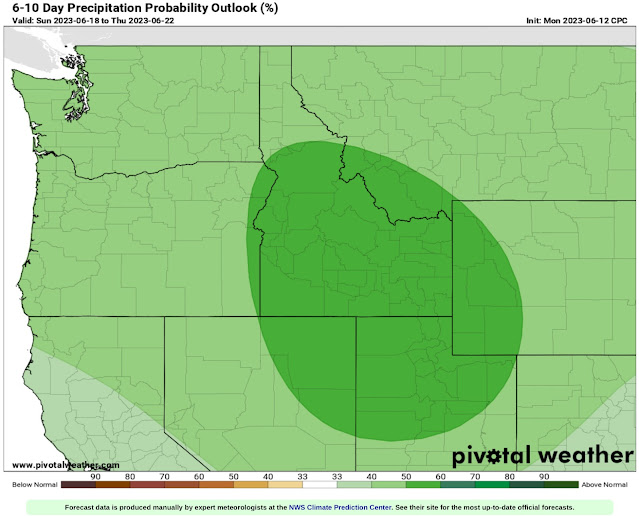
Next, the CPC precipitation outlook, also for June 18-22.
This outlook shows a 40-50% probability of above average precipitation across the entire Western US, with a 50-60% probability centered on Idaho, Northern Utah, NE Nevada, and Western Wyoming.
Stay tuned for a look at the Father’s Day/Juneteenth weekend forecast later this week. Spoiler: it looks to be on the chilly side.


Sounds like we are back to spring weather not summer, which is fine.
ReplyDelete